Walk the Overland Track today and it can feel as though it has always been there. The route is well defined, huts are positioned at practical intervals, walkers generally move in the same direction during the main season, and the journey from Cradle Mountain to Lake St Clair has become one of Australia’s best-known multi-day walks. But the Overland Track did not begin with someone drawing a line between Cradle Mountain and Lake St Clair and deciding to build a walking trail.
What I find particularly interesting is that there really isn’t a single moment when the Overland Track was created. The route gradually emerged from a much older landscape and from many different ways people had moved through it. Long before recreational bushwalking became popular, Aboriginal people had lived in and managed these highlands. Later came explorers, prospectors, miners, hunters, cattlemen and guides. Huts appeared for mining, hunting and tourism. Rough tracks connected valleys and plains. Eventually, parts of those routes and that accumulated knowledge were brought together into the walk we recognise today.
Understanding that history changes the way I think about the Overland Track. It isn’t simply a famous trail through wilderness. It is a path through layers of human history.
A landscape with a much older history
Any history of the Overland Track needs to begin well before the track itself. The country through which it passes lies within the Tasmanian Wilderness World Heritage Area, a landscape with an Aboriginal history stretching back tens of thousands of years. Tasmania Parks and Wildlife Service records that Aboriginal people have lived in, used, managed and modified landscapes within the World Heritage Area for more than 42,000 years, including alpine mountains, river valleys and open buttongrass plains. Targeted burning was among the ways these landscapes were managed.
It would be misleading to simply describe today’s Overland Track as an ancient Aboriginal walking trail. The modern route developed much later and there is not evidence that its precise 65-kilometre alignment follows a single traditional route. But it would be equally misleading to begin its story with European explorers and describe the country as untouched or unknown. People had known, travelled through and shaped this landscape for thousands of years before Europeans arrived.
That distinction matters, particularly when we use a word like “wilderness”. The landscape may appear wild and remote to us today, but it has a deep human history. UNESCO now explicitly recognises the Tasmanian Wilderness World Heritage Area as a cultural as well as natural landscape, reflecting the interaction between Aboriginal people and Country over millennia.
Before bushwalkers came miners, hunters and cattlemen
European activity in the central highlands increased during the nineteenth century as surveyors, prospectors and hunters pushed into increasingly remote country. Pelion Plains provides one of the clearest examples of how this earlier history became intertwined with the eventual Overland Track. Mineral exploration around Douglas Creek began in the 1890s. Initial interest centred on silver, followed by copper exploration as mining companies sank shafts, drove tunnels and cut trenches around Pelion Plain. Most of those ventures failed to find deposits rich enough to sustain commercial mining, but they left behind tracks, workings and huts.
Mining returned during the First World War when demand increased for strategic metals. In 1917, a carefully constructed King Billy pine hut was built for the manager of the Mount Pelion mine. That building survives today as Old Pelion Hut. It is one of my favourite parts of this history because the hut tells the story almost by itself. What we now encounter as a historic bushwalking hut wasn’t built for bushwalkers at all. It was the home and office of a mine manager.
When mining declined, the huts and tracks did not simply disappear. Prospectors, hunters and cattlemen continued using them. Snarers travelled through the high country carrying skins, while cattle were grazed and mustered around Pelion Plain. Existing routes such as the Forth Valley and Mole Creek tracks also helped form parts of the corridor later incorporated into the Overland Track. Then something began to change. Increasingly, people were coming into these mountains not because they needed to extract something from them, but because they wanted to experience them.
Tourism was already finding its way into the mountains
Bushwalking in the region did not suddenly begin with the Overland Track either. By the early twentieth century, local bushmen were guiding visitors into the high country. One of the important figures was hunter, prospector and guide Paddy Hartnett, who used his extensive knowledge of the mountains to take recreational parties into places that would otherwise have been extraordinarily difficult for visitors to reach.
Hartnett also constructed huts. Around 1910 he built huts at Du Cane and Narcissus, followed later by a hut near Mount Pelion East. These structures could serve both tourism and hunting, reflecting that period when recreational use and older working uses of the high country overlapped. The surviving Du Cane Hut remains beside the Overland Track today.
By around 1920 Hartnett was also taking walking parties onto Pelion Plain and using former mining accommodation there. That is another part of the story I find fascinating. People were already walking considerable sections of what would eventually become the Overland Track before there was an Overland Track. The trail was beginning to assemble itself from existing routes, huts, local knowledge and an emerging desire to experience the mountains simply for the pleasure of being there.
Gustav and Kate Weindorfer and a different way of seeing Cradle Mountain
No history of Cradle Mountain can avoid Gustav and Kate Weindorfer, although I think their story is sometimes simplified into Gustav alone campaigning for a national park. Kate deserves to be there too. The couple shared a passion for botany, mountains and the natural environment, and Kate played an important role in introducing Gustav to the Tasmanian landscape. Their vision eventually centred on Cradle Valley, where they established their remarkable forest home and guest chalet, Waldheim, from 1912.
Waldheim became far more than a house in the forest. Visitors could stay there and explore Cradle Mountain, allowing people who might otherwise never have experienced the high country to develop their own connection with it. The Weindorfers became passionate advocates for protecting Cradle Mountain. In 1922, the Cradle Mountain-Lake St Clair area was proclaimed a scenic reserve under the Scenery Preservation Board. It was a crucial step towards the protected landscape we know today and also created an environment in which recreation and tourism could develop more deliberately.
Interestingly, the conservation story was already growing beyond the Weindorfers’ original vision. Visitors guided through Pelion and towards Lake St Clair were discovering that the country worthy of protection extended well beyond Cradle Mountain itself. The idea of a connected mountain landscape was taking shape at roughly the same time as the idea of a connected walking route through it.
Bert Nichols joins the pieces together
If there is one person most closely associated with turning those scattered routes into the Overland Track, it is Ethelbert “Bert” Nichols. Nichols was a trapper, bushman and guide with an intimate knowledge of the central highlands. After the creation of the Cradle Mountain Reserve he became associated with Gustav Weindorfer and was later engaged by the Cradle Mountain Reserve Board to work on a route linking Cradle Valley with Lake St Clair.
His task was wonderfully practical. He blazed trees through forests, erected stakes across open plains and repaired rudimentary huts that earlier trappers had constructed. In effect, Nichols was making it possible for someone without his extraordinary local knowledge to follow a continuous route through the mountains. This is why I think saying that Nichols “built the Overland Track” doesn’t quite capture what happened.
He was working with a landscape already containing mining tracks, hunting routes, huts and knowledge accumulated by people who had travelled through the country before him. His achievement was to help connect those pieces into a route that could be followed recreationally from north to south. In January 1931, Nichols guided Tasmania’s Director of Tourism, E.T. Emmett, and eight members of the recently formed Hobart Walking Club through the mountains. The journey has been described as arguably the first official recreational trip along what was now being called the Overland Track.
Reports of that journey appeared in newspapers, and Emmett later wrote about the experience. Accounts published through the early bushwalking community introduced the route to a much wider audience. People no longer needed to imagine what lay between Cradle Mountain and Lake St Clair. There was now a journey they could follow.
The huts become part of the walk
As more walkers began making the crossing, the infrastructure changed with them. Some of the earliest shelter had never been intended for recreational walking. Mining huts, hunters’ huts and tourism shelters had simply been adopted because they were there. During the 1930s, purpose-built bushwalking huts began appearing. Ranger Lionel Connell constructed Windermere Hut in 1935 and New Pelion Hut in 1936. Their design continued elements seen at Waldheim, including timber construction and steep shingled roofs, but they were fundamentally practical buildings intended to shelter people moving through difficult country.
The huts themselves developed into an evolving history of the track. Connell’s New Pelion Hut burned down in 1943. A replacement was built in 1950, only to burn down in 1967. Another structure followed, before today’s large New Pelion Hut was completed in 2001. That cycle of building, fire, replacement and expansion occurred elsewhere along the track as walker numbers increased and expectations changed.
Yet Old Pelion survived. It now sits quietly away from the main overnight hut, one of the few surviving structures from before the protected area was created. Its walls have carried the names of hunters, cattlemen and bushwalkers since the early twentieth century. For me, places like Old Pelion and Du Cane Hut add something that a modern hut never can. They make it possible to physically encounter earlier layers of the track rather than simply read about them.
From route to bushwalking institution
Through the middle decades of the twentieth century, the Overland Track became increasingly embedded in Tasmanian and Australian bushwalking culture. Walking clubs were important to that development. Their members explored side routes, climbed surrounding mountains, documented conditions and shared information that made independent travel through the high country increasingly possible.
The track itself also became more defined. What had once depended heavily on blazed trees, stakes and local knowledge gradually became a recognisable trail supported by maps, signs, huts and track work. But it was never really just a corridor between two points. The Overland became the backbone of a much broader walking landscape. Side trips led towards Cradle Mountain, Barn Bluff, Mount Ossa and waterfalls along the Mersey. Other routes branched away into country beyond the main trail.
Pine Valley is a good example. Near the southern end of the Overland Track, walkers can leave the main route and travel into Pine Valley, where the hut provides a base for exploring The Acropolis and the extraordinary alpine country of the Labyrinth. Today Parks and Wildlife Service treats it as a distinct overnight side trip rather than part of the main Overland Track. In 2016, Julie and I spent eight days on the Overland Track, spending a few extra days in Pine Valley. It was an incredible experience. You can read about our experience here.
It is easy today to think of the Overland as a precisely defined 65-kilometre trail. Historically, bushwalkers often saw it as something broader: a way into the mountains.
World Heritage changes the context
Another major turning point came in 1982, when the Tasmanian Wilderness was first inscribed on the UNESCO World Heritage List. Cradle Mountain-Lake St Clair National Park became part of a protected landscape recognised internationally for extraordinary natural and cultural values. Subsequent extensions enlarged the World Heritage Area, which today protects an enormous portion of western and central Tasmania.
The significance of the Overland Track was now being considered in a different context. The challenge was no longer simply how to help people walk through the mountains. Managers increasingly had to consider how thousands of people could experience the landscape without progressively damaging the very environment they had come to see. That tension between access and protection has shaped much of the modern history of the Overland Track.
When popularity becomes a management problem
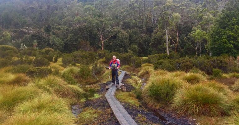
The early walkers following Bert Nichols’ blazes could hardly have imagined the popularity the route would eventually achieve. Increasing numbers brought pressure. Repeated foot traffic widened muddy sections and damaged fragile alpine vegetation. Campsites expanded. Huts became crowded. Toilets and waste had to be managed in places accessible only on foot or by helicopter. Over time, increasingly sophisticated infrastructure appeared. Timber boardwalks, hardened tracks, tent platforms, composting or contained waste systems and larger huts were introduced to concentrate impacts and protect surrounding vegetation.
There is an interesting contradiction here. Some of the infrastructure that makes the Overland feel less “wild” exists precisely because so many people want to experience its wildness. By the beginning of the twenty-first century another problem had emerged: crowding itself was beginning to affect the experience.
In 2005, Tasmania Parks and Wildlife Service introduced the Overland Track booking system in response to the track’s increasing popularity. The system regulated daily departures, limited group sizes, required travel from north to south during the managed period and introduced a booking fee. Parks described the change as a response to concerns that peak-period walker numbers were diminishing the wilderness experience. It was a significant moment in the history of the track. A route once marked by a bushman cutting blazes into trees had become a walk popular enough to require its own managed departure system.
The Overland Track today
The official Overland Track now runs 65 kilometres from Ronny Creek to Narcissus, with most walkers completing the journey over six days. From Narcissus, walkers can cross Lake St Clair by ferry or continue another 17.5 kilometres through the forest beside the lake to Cynthia Bay.
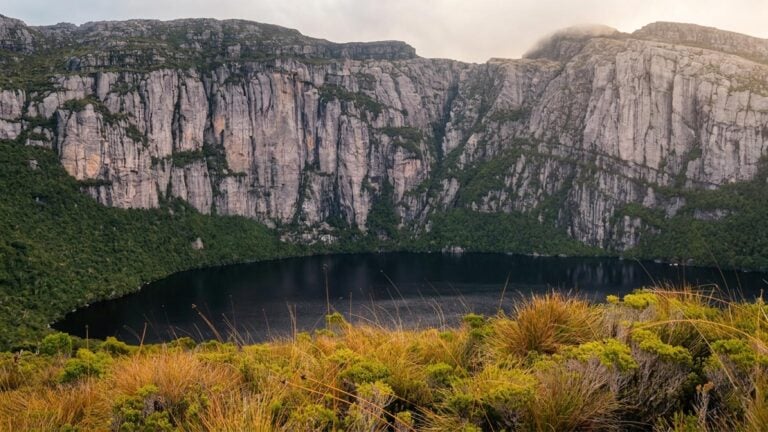
Modern walkers pass through glacial valleys, rainforest, eucalypt forest, buttongrass plains and alpine country. Almost half the route lies above 1,000 metres, and despite all of the improvements to huts and tracks, it remains a serious journey through a remote mountain environment. The experience is obviously very different from the journey Nichols guided in 1931. There are modern huts, boardwalks, toilets, defined campsites and detailed maps. During the main walking season there are bookings, daily departure limits and a steady progression of people travelling south.
But look carefully and much of the older story is still there. Old Pelion Hut recalls an unsuccessful copper mine. Du Cane Hut belongs to an era when hunting and guided tourism existed side by side. Waldheim tells the story of Gustav and Kate Weindorfer and their belief that Cradle Mountain deserved protection.
Bert Nichols’ name lives on at Windy Ridge, where the modern hut commemorates the bushman who helped transform scattered routes through the mountains into a journey other people could follow. And beyond the infrastructure lies the much older cultural landscape of Tasmanian Aboriginal people, whose connection to these mountains predates every hut, mine, blaze and boardwalk by tens of thousands of years. That, to me, is what makes the history of the Overland Track so interesting. It wasn’t created by one person, in one year, for one purpose. It evolved.
Aboriginal Country became overlaid with exploration, mining, hunting, cattle grazing and early tourism. Working routes became recreational tracks. Mining and hunting huts became bushwalking shelters. Conservation changed the purpose of the landscape. Bushwalkers connected the mountains. Increasing popularity eventually required the wilderness experience itself to be managed. When we walk the Overland Track today, we are following more than a trail between Cradle Mountain and Lake St Clair. We are walking through the accumulated history of how people have known, used, explored, protected and ultimately learned to value one of Tasmania’s most remarkable landscapes.
Sources
- Tasmania Parks and Wildlife Service, Aboriginal Heritage, including Aboriginal occupation and management of the Tasmanian Wilderness World Heritage Area for more than 42,000 years.
- UNESCO World Heritage Centre, Tasmanian Wilderness, for the cultural and natural significance of the World Heritage Area and its 1982 inscription.
- Tasmanian Heritage Register, Pelion Copper Mine including Old Pelion Hut, for Pelion mining history, early tracks, hunters, cattlemen, tourism, Old Pelion Hut and development of the Overland Track.
- Tasmanian Heritage Council historical research into Tasmanian recreational huts, for Paddy Hartnett’s early tourism huts, Waldheim, Windermere Hut and New Pelion Hut.
- Tasmania Parks and Wildlife Service, Cradle Mountain, for the Weindorfers, Waldheim and the protection of the Cradle Mountain-Lake St Clair landscape.
- Tasmania Parks and Wildlife Service, Honouring Kate Weindorfer, for Kate Weindorfer’s role in the couple’s conservation work and the history of Waldheim.
- Australian Dictionary of Biography, Gustav Weindorfer, for biographical information and the establishment of Waldheim.
- Friends of Cradle Valley, Ethelbert ‘Bert’ Nichols, for Nichols’ track work and the January 1931 journey with E.T. Emmett and members of the Hobart Walking Club.
- Tasmania Parks and Wildlife Service, Windermere Hut, Toilet and Group Platform Replacements Environmental Impact Statement, for the history and purpose of the Overland Track booking system introduced in 2005.
- Tasmania Parks and Wildlife Service, Overland Track and Overland Track Walk Notes, for the current route, huts, side trips, Pine Valley and present-day walking information.





Media: https://www.facebook.com/photo.php?fbid=10174995690670591&set=p.10174995690670591&type=3
Just finished hiking it a few weeks ago
Daniel Sue now that looks a tad chilly. Hope you had an amazing time.
Trail Hiking Australia I did … Thought the weather was quite mild for winter.
Daniel Sue looks cold when I’m sitting at my desk right now, but I know once you’re in it, things are very different. Glad you enjoyed it and were fortunate with the mild weather. I’m a bit jealous.