Hike at a glance
Length
Duration
Difficulty
Trail type
Route details
Max elevation: 925m
Min elevation: 400m
Total Ascent: 632m
Check current conditions
Track conditions, access and closures can change quickly due to weather, fire, maintenance or safety concerns. Always check the relevant land manager’s website before you visit. Trail Hiking Australia does not provide real-time track and closure monitoring, and land managers remain the authoritative source for current alerts, closures and access restrictions.
About this trail
Trail difficulty

Steep, rough, and demanding
These are challenging walks suited to experienced hikers. Expect sustained climbs, rough and uneven terrain, and longer distances.
Tracks may be less defined, and signage can be limited, so navigation awareness is important. These walks require good fitness, confidence on difficult terrain, and the ability to manage fatigue over time.
Safety note: Fatigue, poor navigation, or a sudden weather change can turn a hard walk into a serious situation.
Planning information
Preparation matters: Plan your day hike well and bring the right gear, weather-appropriate layers, food and plenty of water. Before you head out, read up on bushwalking safety and use this day hike planning guide to make sure you're ready. Need help getting started? Check out the full hike preparation guide.
Map and GPX file
Safety and preparation
Think safety first
Australian conditions can turn a small oversight into a serious situation faster than most walkers expect. The Hiking Safety Systems and planning calculators are designed to help you identify and close those gaps before you leave home. Work through the Interactive Safety Scenarios to see how incidents unfold, then use the tools to build your plan and make sure a trusted contact has your trip details before you head out.
Let someone know
Before you go, complete a trip intentions form and share it with a trusted contact. Agree on a Late-Back Time and ask them to call 000 (Police) if you have not checked in. A clear trip plan is one of the simplest and most effective safety steps you can take, and it only takes two minutes.
Heading somewhere remote, off-track or overnight? Use the comprehensive trip intentions form instead — your emergency contact will need more detail. Register your trip plan here →
Free checklists
Download the hiking preparation and safety checklists before leaving home to help you think through your plans. They help ensure important considerations are not overlooked and support safer decision-making on the trail.
Getting there and where to stay
Need a rental car to get you to the hike? Find one here →
Accommodation nearby
Find hotels, cabins, and campgrounds near the trailhead. Click the button below to open an interactive map automatically centred on this hike's location — no searching required.
Or browse accommodation in nearby towns: Ararat, Beaufort, Elmhurst, Lake Bolac, Moyston, Skipton, Willaura
Explore the region
About the region
Explore nearby hikes



Photo gallery
/Mount-Langi-Ghiran-Hike_3.jpg "Mount Langi Ghiran Hike (15.2km)")
/Mount-Langi-Ghiran-Hike_33.jpg "Mount Langi Ghiran Hike (15.2km)")
/Mount-Langi-Ghiran-Hike_17.jpg "Mount Langi Ghiran Hike (15.2km)")
/Mount-Langi-Ghiran-Hike_25.jpg "Mount Langi Ghiran Hike (15.2km)")
/Mount-Langi-Ghiran-Hike_46.jpg "Mount Langi Ghiran Hike (15.2km)")
/Mount-Langi-Ghiran-Hike_38.jpg "Mount Langi Ghiran Hike (15.2km)")
/Mount-Langi-Ghiran-Hike_41.jpg "Mount Langi Ghiran Hike (15.2km)")
/Mount-Langi-Ghiran-Hike_45.jpg "Mount Langi Ghiran Hike (15.2km)")
/Mount-Langi-Ghiran-Hike_39.jpg "Mount Langi Ghiran Hike (15.2km)")
/Mount-Langi-Ghiran-Hike_9.jpg "Mount Langi Ghiran Hike (15.2km)")
/Mount-Langi-Ghiran-Hike_53.jpg "Mount Langi Ghiran Hike (15.2km)")
/Mount-Langi-Ghiran-Hike_7.jpg "Mount Langi Ghiran Hike (15.2km)")
/Mount-Langi-Ghiran-Hike_1.jpg "Mount Langi Ghiran Hike (15.2km)")
/Mount-Langi-Ghiran-Hike_32.jpg "Mount Langi Ghiran Hike (15.2km)")
/Mount-Langi-Ghiran-Hike_29.jpg "Mount Langi Ghiran Hike (15.2km)")
Do you have any photos from this hike?
Your photos can help others plan. Share shots from along the trail so fellow hikers know what to expect.
Weather on the trail
The map below shows the rain forecast for the trail area. Tap the toggle in the top right corner to explore other layers including wind, temperature, UV index, thunderstorms, fire danger, and weather warnings — all useful for planning a safe hike.
Trail Reviews
Notice something different about this trail?
Whether it’s a new feature, a route change, or a closure, share your update so we can keep our info accurate and helpful for fellow hikers.
Acknowledgement of Country

Trail Hiking Australia acknowledges the Traditional Owners of the lands on which we hike and pay respects to their Elders, past and present, and we acknowledge the First Nations people of other communities who may be here today.


4 Reviews on “Mount Langi Ghiran Hike (15.2km)”
Loved this one, good fun.
Rob Gillespie I agree. Often misses out because everyone heads to Mount Cole / Buangor but it’s a fun hike. Great indigenous rock art site nearby too
Chris Wells Keith’nYvonne Muller Sylvia Hookey Melissa Hehir might be a good one girls.
Was this affected by the bushfire last summer?
Helen Wyn I believe the fire didn’t spread that far west. Lucky there’s farmland in between.
Fun hike this one. A little bit of everything.
Thanks for introducing me to the walk. Loved it. I followed the entire gpx trail October 2017. Our walking speed was a bit above average and we took 6 hours. Yesterday I did the walk again. This time almost halving the walk with a car shuffle between -37.315817,143.095245 and -37.283324,143.107245. My group was slow and took 5 hours for half the trail.
We went as a group of 8 on 17/9/18 and it was one of our favourite and most fun walks. What a beautiful, quiet, bird-filled and surprising park!
We are a pretty slow group and it took us 6 hours including stops for lunch, photos, general faffing.
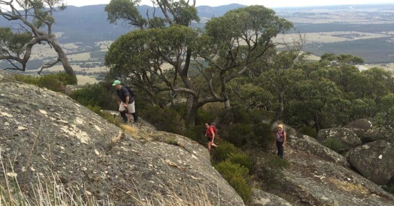
It’s a fairly gentle incline on gravel path until the last 15 minutes to the summit which is ‘off track’ and over big beautiful granite boulders. There is a rock cairn beside the track which indicates when to turn right and make your own way to the top. The view is impressive.
Getting down the other side to Hidden Lagoon is difficult – and NOT recommended in wet weather!!! We did it in dry conditions, and it was cray.
I won’t offer any advice on finding ‘the way’ because we surely didn’t! Expect steep, slippery boulders, jerk thorny plants to break your fall(s), and the thickest bracken/fern gully to bust through. It was a lot of fun, and we survived with just a few scratches. We didn’t follow exactly the GPX file here so, look, there might have been an easier way?
The campsite at the starting point looks really lovely, flat, with fire pits, toilets and lots of birdlife. We saw a few suitable overnight camp spots near the top that are flat and sheltered.
We all LOVED this walk, can definitely recommend it for those who don’t mind some grazed hands and offtrack exploring.