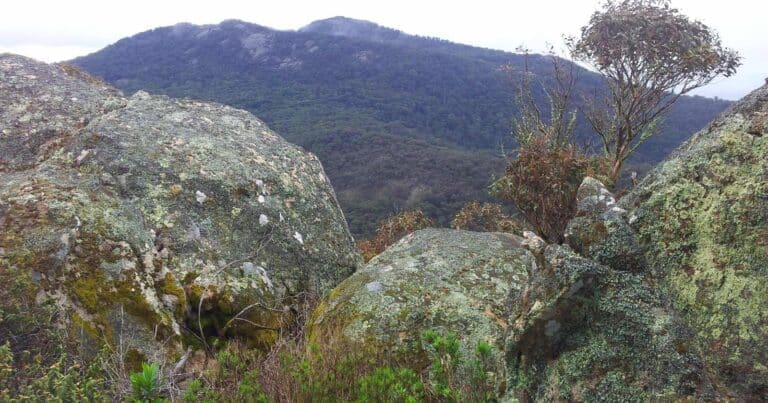
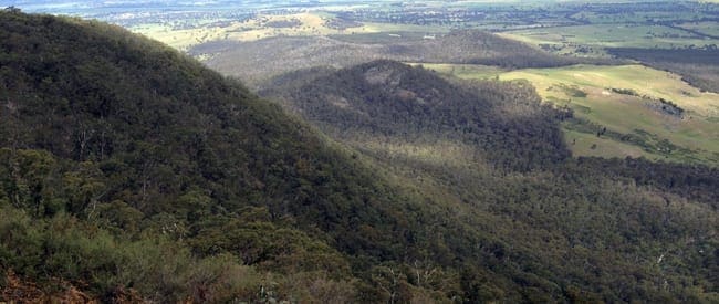
The Langi Ghiran and Mount Gorrin hike commences at the visitors area. Walk via the reservoir where you will join the Easter Creek Track. Follow this track until the trail ends. From here you will commence hiking off-trail in order to gain the summit of Langi Ghiran. The next section of the hike is completely off-trail as you descend from the summit to hidden lagoon in thew valley below. You will need to pick the best path down to the valley. Once you locate hidden lagoon it should be easy to locate the nearby gravel track and follow this back to the start point at the visitors area.
Langi Ghiran is a mountain 14 kilometres east of Ararat in Victoria, Australia, and is home to the Djab Wurrung people who have lived on this land for tens of thousands of years. Rugged granite peaks and gentle sloping woodlands are the dominant features of this local landmark. A pleasant walk to the mountain summit presents a view of ancient Red Gums on the surrounding plains skirted by Mount Buangor in the east and the Grampians in the distant west. Lar-ne-jeering (Langi Ghiran) is Djab Wurrung language for 'home of the black cockatoo'.
The section between Langi Ghiran and hidden lagoon is mostly off trail. Off track walking is permitted in the park. Bring a GPS, but also a map and compass (never rely completely on a GPS).
Langi Ghiran is a beautiful state park that not many people know about. It is a 'hidden gem' that provides many beautiful and wild walks for those who are lucky enough to visit this amazing area.
Water
There is no water at Langi Ghiran, byo water
Getting there
From Melbourne follow the Western Freeway passing Ballarat to Beaufort. Continue along the Western Highway for another 30kms to the Langhi Ghiran State Park on the right. Kartuk Road turnoff is 12kms before reaching Ararat. Follow the unsealed road for 4kms to the Visitors Area
Please don’t copy GPX files or content from this site to AllTrails or other platforms. Each trail has been personally mapped, documented, and refined to support Australia’s bushwalking and hiking community. While some details come from land managers, every listing reflects significant personal effort. This is a free, community-driven initiative—your respect helps keep it that way.
Total distance: 15233 m
Max elevation: 925 m
Min elevation: 400 m
Total climbing: 632 m
Total descent: -632 m
Getting there
Getting to the trailhead: Langi Ghiran State Park.
From Melbourne, take the National Highway M8 for 130km to the Western Highway/A8 in Windarmee. Follow the A8 for a further 56km to the Langi Ghiran Rest Area on the right hand side of the Western Hwy. Park your cars here.
Closest towns to this walk: Ararat, Beaufort, Elmhurst, Lake Bolac, Moyston, Skipton, Willaura
Access conditions
- 2WD Access
- Gravel Road
- Large Car Park
- Public Toilets
- Picnic Table
- Campfire Pit
- Camping Area
About the region
Rugged granite peaks and gentle sloping woodlands are the dominant features of this park. A pleasant walk to the mountain summit presents a view of ancient red gums on the surrounding plains skirted by Mount Buangor in the east and the Grampians in the distant west. Lar-ne-gerin (Langi Ghiran) is from the Djab Wurrung language meaning 'home of the black cockatoo'.
Mount Gorrin is a mountain 14 kilometres east of Ararat in Victoria, Australia, and is home to the Djab Wurrung people who have lived on this land for tens of thousands of years. Rugged granite peaks and gentle sloping woodlands are the dominant features of this local landmark. A challenging off-trail hike to the mountain summit presents a view of ancient Red Gums on the surrounding plains skirted by Mount Buangor in the east and the Grampians in the distant west.
Similar walks nearby
Looking for more walks in or near Langi Ghiran State Park? Try these trails with a similar difficulty grade.
Favourite

Favourite

Favourite

Favourite

Mount Cole State Forest & Mount Buangor State Park
Track grade
Grade 4 (Hard) -
Challenging Walks for Experienced Walkers: Grade 4 on the
AWTGS signifies challenging walking tracks. Bushwalking experience is recommended for these tracks, which may be long, rough, and very steep. Directional signage may be limited, requiring a good sense of navigation. These walks are suited for experienced walkers who are comfortable with steeper inclines, rougher terrain, and potentially longer distances.
Explore safe
Plan ahead and hike safely! Carry enough water, pack layers for changing conditions, and bring safety gear like a torch, PLB, and reliable communication device. Check official sources for trail updates, closures, and access requirements, and review local weather and bushfire advice. Most importantly, share your plans with someone before you go. Being prepared makes for a safer and more enjoyable hike! Stay Safe, Explore More, and Always #ExploreSafe.
Packing checklists
What you carry in your pack depends on factors like weather, terrain, and your adventure type. Not sure what to bring? My free planning, food, and packing checklists are a great starting point, covering day hikes, overnight trips, and multi-day adventures. Use them to customise your kit and always prioritise safety.
Let someone know
Before heading out, take a moment to fill out your trip intentions form. It’s a quick way to share your hike details with family or friends. If something goes wrong, they can notify emergency services, ensuring a faster response and peace of mind. Stay safe and enjoy your adventure
Suggest an edit
Spotted a change on this trail? Maybe there are new features, the route has shifted, or the trail is permanently closed. Whatever the update, I’d love your input. Your feedback helps fellow hikers stay informed and ensures that our trail info stays fresh and reliable.
/Mount-Langi-Ghiran-Hike_15.jpg)
/Mount-Langi-Ghiran-Hike_52.jpg)
/Mount-Langi-Ghiran-Hike_4.jpg)
/Mount-Langi-Ghiran-Hike_45.jpg)
/Mount-Langi-Ghiran-Hike_46.jpg)
/Mount-Langi-Ghiran-Hike_11.jpg)
/Mount-Langi-Ghiran-Hike_38.jpg)
/Mount-Langi-Ghiran-Hike_2.jpg)
/Mount-Langi-Ghiran-Hike_14.jpg)
/Mount-Langi-Ghiran-Hike_32.jpg)
/Mount-Langi-Ghiran-Hike_25.jpg)
/Mount-Langi-Ghiran-Hike_23.jpg)
/Mount-Langi-Ghiran-Hike_39.jpg)
/Mount-Langi-Ghiran-Hike_17.jpg)
/Mount-Langi-Ghiran-Hike_6.jpg)


4 Reviews on “Mount Langi Ghiran Hike (15.2km)”
Loved this one, good fun.
Rob Gillespie I agree. Often misses out because everyone heads to Mount Cole / Buangor but it’s a fun hike. Great indigenous rock art site nearby too
Chris Wells Keith’nYvonne Muller Sylvia Hookey Melissa Hehir might be a good one girls.
Was this affected by the bushfire last summer?
Helen Wyn I believe the fire didn’t spread that far west. Lucky there’s farmland in between.
Fun hike this one. A little bit of everything.
Thanks for introducing me to the walk. Loved it. I followed the entire gpx trail October 2017. Our walking speed was a bit above average and we took 6 hours. Yesterday I did the walk again. This time almost halving the walk with a car shuffle between -37.315817,143.095245 and -37.283324,143.107245. My group was slow and took 5 hours for half the trail.
We went as a group of 8 on 17/9/18 and it was one of our favourite and most fun walks. What a beautiful, quiet, bird-filled and surprising park!
We are a pretty slow group and it took us 6 hours including stops for lunch, photos, general faffing.
It’s a fairly gentle incline on gravel path until the last 15 minutes to the summit which is ‘off track’ and over big beautiful granite boulders. There is a rock cairn beside the track which indicates when to turn right and make your own way to the top. The view is impressive.
Getting down the other side to Hidden Lagoon is difficult – and NOT recommended in wet weather!!! We did it in dry conditions, and it was cray.
I won’t offer any advice on finding ‘the way’ because we surely didn’t! Expect steep, slippery boulders, jerk thorny plants to break your fall(s), and the thickest bracken/fern gully to bust through. It was a lot of fun, and we survived with just a few scratches. We didn’t follow exactly the GPX file here so, look, there might have been an easier way?
The campsite at the starting point looks really lovely, flat, with fire pits, toilets and lots of birdlife. We saw a few suitable overnight camp spots near the top that are flat and sheltered.
We all LOVED this walk, can definitely recommend it for those who don’t mind some grazed hands and offtrack exploring.