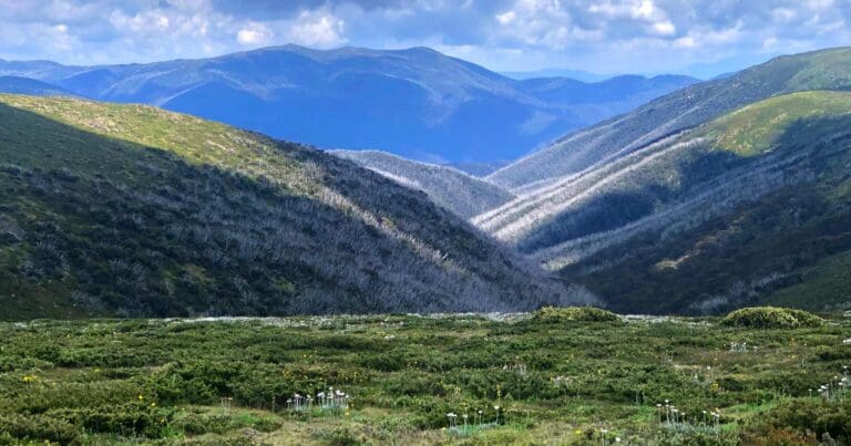
Spargo and Derrick Huts is an 11km, grade 4 hike located in Alpine National Park, Victoria. The hike should take around 4 hours to complete.
Hike overview
Spargo and Derrick Huts Hike: A Trail Steeped in History
Nestled amidst the breathtaking landscapes of Alpine National Park in Victoria, Australia, lies the captivating Spargo and Derrick Huts hike. This moderately challenging 11 kilometre return trail offers an immersive experience into the region's rich history and natural splendor. Prepare to be captivated by panoramic vistas, quaint alpine huts, and diverse flora and fauna as you traverse this enchanting route.
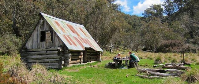
The Spargo and Derrick Huts hike embarks from the well-maintained Mount Hotham Alpine Resort, leading you along the Australian Alps Walking Track (AAWT). As you ascend, follow the AAWT pole line until you reach pole 84, where an unmarked walking track diverges downhill and southward for approximately 1 kilometre. This section of the trail unveils the captivating Spargo Hut, a heritage-listed structure built in 1927 by renowned prospector Bill Spargo.
Bill Spargo, a prominent local figure, played a pivotal role in shaping the region's history. His remarkable discoveries, including the Red Robin Mine, and his entrepreneurial spirit, as evidenced by the establishment of the first Hotham Heights guest house, cemented his legacy. The Spargo Hut stands as a testament to his pioneering spirit and enduring contributions to the area.
Spargo Hut, nestled amidst the alpine wilderness, provides a welcome respite for hikers. Its rustic charm and historical significance offer a unique opportunity to connect with the region's past. Take a moment to appreciate the hut's simple yet sturdy construction, a testament to the resourcefulness and resilience of early settlers.
Continuing your trek, you'll encounter Derrick Hut, a tribute to Charles Derrick, a passionate cross-country skier who tragically perished in a blizzard. This day shelter, nestled amidst ancient snow gums, offers a tranquil refuge for skiers and hikers alike.
As you immerse yourself in the surrounding wilderness, be sure to keep an eye out for the diverse flora and fauna that inhabit the region. Alpine wildflowers paint the landscape with vibrant hues, while native birdsong fills the air with enchanting melodies. Keep your eyes peeled for elusive creatures like wombats, wallabies, and even the occasional eagle soaring overhead.
After completing the loop, you'll return to the Mount Hotham Alpine Resort. The Spargo and Derrick Huts hike rewards you with a profound appreciation for the region's historical significance, its breathtaking natural beauty, and the resilience of the human spirit.
Route and GPX file
Max elevation: 1821 m
Min elevation: 1650 m
Total climbing: 481 m
Total descent: -481 m
Trail location
Sorry, no records were found. Please adjust your search criteria and try again.
Sorry, unable to load the Maps API.
Getting there
The hike starts at the Mount Loch carpark. To get there, take the Maroona Road from Mansfield. The carpark is located about 20 kilometres from Mansfield.
Gallery
If you have any photos from this hike and are happy to share them, please upload your .jpg files here.
Please note: Uploading photos does not transfer ownership of copyright away from you. If requested, you will be credited for any photos you provide and can ask they be deleted at any time.
About the region
The Alpine National Park is a national park located in the Central Highlands and Alpine regions of Victoria, Australia. The 646,000-hectare national park is located northeast of Melbourne. It is the largest National Park in Victoria, and covers much of the higher areas of the Great Dividing Range in Victoria, including Victoria's highest point, Mount Bogong at 1,986 metres and the associated subalpine woodland and grassland of the Bogong High Plains. The park's north-eastern boundary is along the border with New South Wales, where it abuts the Kosciuszko National Park.
Similar trails nearby
Explore Safe
While planning your hike, it’s important to check official government sources for updated information, temporary closures and trail access requirements. Before hitting the trail, check local weather and bushfire advice for planned burns and bushfire warnings and let someone know before you go. Plan ahead and hike safely.
Let someone know
Adventure with peace of mind: Fill out your trip intentions form. Before you hit the trail, fill out an online form to privately send important details about your hike to your family or friends. If you don’t return on time, they can easily alert emergency services, preventing worry and ensuring a swift response. Hike with peace of mind and enjoy your outdoor adventure to the fullest. Be smart, be safe: Register your plans here.
Gear to consider

My free planning, food and packing checklists provide an introduction to things your could consider (as well as the Ten Essentials) on your day, overnight and multi-day adventures. Customise your kit according to your personal needs, always considering safety first.
Suggest an edit
Does this hikes information need updating? Sometimes the route, trail features or access conditions change.
Acknowledgement of Country
Trail Hiking Australia acknowledges the Traditional Owners of the lands on which we hike and pay respects to their Elders, past and present, and we acknowledge the First Nations people of other communities who may be here today.


