Sorry, no records were found. Please adjust your search criteria and try again.
Sorry, unable to load the Maps API.
Explore stunning hiking trails of Toolibin Nature Reserve
Discover the diverse trails of Toolibin Nature Reserve, Western Australia, offering hikes and walks for all skill levels and interests. Find your perfect adventure today.
Discover 1 hiking trail in Toolibin Nature Reserve
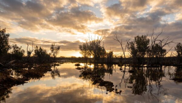

Where a Wheatbelt Wetland Still Holds Fresh Water
Overview
Toolibin Nature Reserve protects one of the most distinctive wetlands in Western Australia’s Wheatbelt. About 40 kilometres east of Narrogin and roughly 200 kilometres south-east of Perth, it centres on Toolibin Lake, a large intermittently inundated wetland set within an agricultural landscape. What makes the place stand out is that the lake remains fresh to brackish and perched above the surrounding saline groundwater, a rare condition in this part of the south-west.
The reserve covers the Ramsar-listed Toolibin Lake wetland, recognised internationally for its ecological importance. The lake does not hold water all the time. Instead, it fills from surface runoff in wetter periods and then gradually dries again, creating the wet-and-dry cycle that shapes the whole character of the reserve.
Highlights
The defining feature here is the broad lake basin itself, with its unusual wooded wetland spreading across the lake floor. When conditions are right, water moves through stands of sheoak and paperbark, which is a striking sight in a landscape where many comparable wetlands have been altered by salinity.
There is also a strong sense of contrast around the lake margins. Slight rises support open eucalypt woodland, banksias and heath, while the lake floor is marked by gilgai mounds, small natural undulations that add texture to the wetland surface and help give Toolibin its distinctive appearance.
Best Time to Visit
Toolibin changes character with the seasons and with the run of wetter years. The cooler months from late autumn to spring are generally the most pleasant time to be in the Wheatbelt, and they also align with the period when rainfall is most likely to influence water levels. In wet years the reserve feels very different from dry years, so timing can shape what you see more than the calendar alone.
If the lake has filled or is close to full, that is when the wetland is at its most dynamic for birdlife. In drier phases, the appeal shifts to the lake’s structure, woodland setting and the unusual survival of this wetland type in the middle of the Wheatbelt.
Plants and Animals
Toolibin is the last large sheoak-dominated wetland of its kind in the bioregion, with mostly living trees still standing across the lake bed. Paperbark also plays a major role in the wetland vegetation, while the slightly higher ground supports eucalypt woodland, sheoaks, banksias and heath.
The reserve is especially important for waterbirds when the lake is full or nearly full. Twenty-five waterbird species are known to breed here, and 50 species have been recorded overall, including freckled duck, cormorants, egrets, night herons and spoonbills. The wetland is also recognised nationally as a threatened ecological community, reflecting just how unusual this surviving patch of Wheatbelt wetland has become.
Culture and Heritage
Toolibin Nature Reserve lies within Noongar country. Toolibin Lake is identified as part of the Gnaala Karla Booja Indigenous Land Use Agreement area, reflecting the continuing Aboriginal connection to this part of south-west Western Australia.
Find more places to explore…
Help expand the trail collection!
Know of an official trail not listed on Trail Hiking Australia? I’m focused on showcasing the best tracks managed by land managers, and I’d love your help! Sharing a trail adds to our community and helps others discover safe, new adventures.
Submit your trail here

