Sorry, no records were found. Please adjust your search criteria and try again.
Sorry, unable to load the Maps API.
Explore stunning hiking trails of Darling Range Conservation Area
Discover the diverse trails of Darling Range Conservation Area, Tasmania, offering hikes and walks for all skill levels and interests. Find your perfect adventure today.
Discover 1 hiking trail in Darling Range Conservation Area
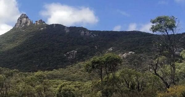

Granite Ridges and Wet Gullies on Flinders Island
Overview
Darling Range Conservation Area protects a substantial piece of eastern Flinders Island, where granite ridges, steep slopes and sheltered gullies create a landscape quite different from the island’s broader coastal plains. The reserve covers about 5,476 hectares and sits within a part of Flinders Island known for its rugged inland relief and patchwork of forest, woodland, scrub and heath. This is a place where the shape of the country really matters, with short catchments, rocky high ground and wetter pockets combining to give the area its own character.
For walkers, the appeal of Darling Range lies in that contrast. One moment the country feels open and windswept, the next it closes into damp gullies and thicker vegetation. It is a quieter, less publicised part of Flinders Island, but one with strong natural values and a real sense of topographic variety.
Highlights
The defining feature here is the range itself: a run of granite high ground that stands out within the Furneaux Group and gives this part of Flinders Island a more rugged profile. The slopes and ridgelines create long changes in aspect and elevation, which in turn shape the scenery, from exposed rocky country to more sheltered folds in the land.
Another standout is the way the reserve holds wetter gullies within a generally dry island setting. These gullies soften the landscape and add texture, with seasonal streams and denser vegetation tucked below the ridges. That mix of hard granite landforms and protected green pockets is what makes Darling Range feel distinctive.
Best Time to Visit
Autumn, winter and spring are usually the most rewarding times to appreciate the area’s natural character, when cooler weather suits longer walks and the gullies and forests tend to feel at their freshest. After decent rain, the contrast between the rocky ridges and the wetter drainage lines is especially noticeable.
Spring is also a good season for seeing the reserve at its most detailed, with heath and understorey plants more likely to be active and visible. In the warmer months the country can feel drier and more exposed, which changes the mood of the landscape rather than diminishing it.
Plants and Animals
Darling Range supports a mix of eucalypt woodland, forest, scrub and heath shaped by granite soils, rainfall and landform. On the higher granite slopes, peppermint eucalypt forest and woodland are typical, while wetter gullies can carry dense shrubby vegetation, including paperbark in damp sites. That variety of habitats is one of the reserve’s biggest ecological strengths.
The area is recognised for threatened species. Darling Range has been recorded as habitat for the forty-spotted pardalote on Flinders Island, and it also supports significant threatened flora, including the swamp pelican-orchid in a wet gully and records of dwarf wedgepea. These species point to the importance of the reserve not just as scenic country, but as a refuge for specialised plants and animals tied to particular soils, vegetation types and sheltered sites.
Find more places to explore…
Help expand the trail collection!
Know of an official trail not listed on Trail Hiking Australia? I’m focused on showcasing the best tracks managed by land managers, and I’d love your help! Sharing a trail adds to our community and helps others discover safe, new adventures.
Submit your trail here