Sorry, no records were found. Please adjust your search criteria and try again.
Sorry, unable to load the Maps API.
Explore stunning hiking trails of Mount Schank State Heritage Area
Discover the diverse trails of Mount Schank State Heritage Area, South Australia, offering hikes and walks for all skill levels and interests. Find your perfect adventure today.
Discover 1 hiking trail in Mount Schank State Heritage Area

Where a Young Volcano Rises from the Limestone Plain
Overview
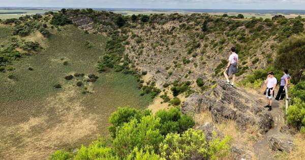
Mount Schank State Heritage Area protects one of South Australia’s clearest volcanic landforms, centred on a steep cinder cone that rises about 100 metres above the flat coastal plain. The heritage area covers roughly 150 hectares around the volcano, about 12 kilometres south of Mount Gambier in the Limestone Coast, and also includes part of the original volcanic fissure to the north and a small blowhole area on the eastern side.
What makes the place so memorable is how intact the cone still looks. Despite past quarrying and farming nearby, the overall form remains sharply defined, which makes it unusually easy to read the shape of the eruption in the landscape itself.
Highlights
The dominant feature is the cone-shaped crater, which stands out abruptly from country that is otherwise low and level. It is a strong, simple landform, but there is plenty of geological detail packed into it, from the main crater to the smaller line of scoria cones that marks the old fissure running to the north-west.
Mount Schank is also distinctive for the way its volcanic story differs from nearby Mount Gambier. Here, the craters sit at or above the level of the surrounding plain, so they stayed dry rather than filling with water. That leaves the shape of the cone and crater especially clear, with the mountain reading as a complete volcanic structure rather than a lake landscape. The area is recognised as a South Australian Geological Monument.
Best Time to Visit
Cooler months generally suit this exposed volcanic landscape best. In autumn, winter and spring, the open slopes and crater rim are usually more comfortable for walking and for taking in the broader Limestone Coast scenery, while the greener ground cover can soften the dark scoria and lava country around the cone.
Clear days are especially rewarding here because the mountain rises so cleanly above the surrounding plain, giving the whole place a spacious, open character rather than a closed bush setting.
Plants and Animals
Official material for Mount Schank focuses far more on geology and landform than on detailed flora and fauna, so this is best understood as a volcanic site where vegetation sits lightly over the cone and crater rather than defining the experience. Earlier descriptions of the mountain noted grassy outer slopes with scattered she-oaks, which still fits the open, exposed feel of the place.
Culture and Heritage
Mount Schank’s heritage value is tied not only to its geology but also to its place in south-east South Australia’s cultural history. A Boandik story connected with the Craitbul ancestor links Mount Schank with nearby volcanic features in the district, preserving an account associated with the area’s volcanic past.
The mountain also has a long recorded history in European exploration and science. It was named in December 1800 by James Grant during his voyage along the south-east coast, and in the nineteenth century it drew the attention of travellers and geologists, including Julian Tenison Woods, whose work helped establish some of the first systematic geological studies in South Australia.
Find more places to explore…
Help expand the trail collection!
Know of an official trail not listed on Trail Hiking Australia? I’m focused on showcasing the best tracks managed by land managers, and I’d love your help! Sharing a trail adds to our community and helps others discover safe, new adventures.
Submit your trail here

