Sorry, no records were found. Please adjust your search criteria and try again.
Sorry, unable to load the Maps API.
Explore hiking trails of Coalseam Conservation Park
Discover the diverse trails of Coalseam Conservation Park, Western Australia, offering hikes and walks for all skill levels and interests. Find your perfect adventure today.
Discover 2 hiking trails in Coalseam Conservation Park
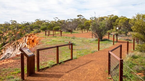

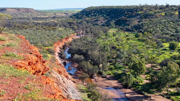

Wildflowers, Coal Seams and Short Walks at Coalseam Conservation Park
Coalseam Conservation Park sits on the Irwin River about 33 kilometres north-east of Mingenew in Western Australia, roughly 400 kilometres north of Perth and a four and a half hour drive if you don’t stop too often. Most people make that drive for one reason. After the winter rains, the flats and low rises through the park fill with everlastings in yellow, pink and white, along with plenty of other flowering species, and it becomes one of the best wildflower displays in the northern Wheatbelt. For a few weeks each spring this quiet 754 hectare park turns into one of the busiest places in the Mid West.
The flowers get the attention, but the rock underneath is the more unusual story. In 1846 the Gregory brothers found coal exposed in the riverbank here, the first coal discovered in Western Australia. Those seams are still visible today, which makes this one of the few places anywhere that you can walk up and put your hand on a coal seam without going underground. Above and below the coal, the Irwin River has cut through the layers and left a clean cross section in the cliffs. Holmwood Shale at the bottom at around 280 million years old, then High Cliff Sandstone, then the Irwin River Coal Measures, then much younger sandstone and laterite capping it all off. Marine fossils sit in some of those bands, which tells you this dry inland country was once seabed.
The park is on Yamatji Country and holds long standing cultural value as a source of food and medicine, with artefacts from that occupation still present in the landscape. Worth carrying that in your head as you walk, and worth leaving everything exactly where you find it.
All trails in the park are short, so this is a place for a series of relaxed walks rather than a big day out. The Plateau Loop Trail is the main one, 3.2 kilometres starting from Miners campground. It works through eucalypt woodland that has become genuinely rare in this part of the Wheatbelt, then climbs onto a plateau ridge with long views back over the valley. Walk it slowly and quietly and you’ll pick up a lot more of the birdlife and reptiles than the people ahead of you did. The Irwin Lookout Trail is a much shorter option at 560 metres, and it puts you on the cliff tops above the river. Wedge-tailed eagles and peregrine falcons hunt this valley, and there’s a fair chance you’ll be watching them at eye level rather than looking up.
The other stops are more about the sitting than the walking. Riverbend is where the rock cross section is most obvious, and it’s the clearest place to make sense of how the surrounding country was built. Irwin Lookout gives you the view over the river and across the park. Fossil Picnic Area sits on the east bank of the Irwin River, which is a good spot to eat and take in the view without going far. Miners Picnic Area is the busiest, with flowers close by in season, the riverbed to explore and an old mine shaft nearby.
Camping needs to be booked before you leave home, and the campgrounds fill fast in wildflower season. Miners campground is caravan friendly and has picnic tables and toilets, and when it fills, the overflow sites open at Breakaway Campground on the cliff above the river. From late July through to October there’s a three night limit so more people get a turn. There’s no drinking water in the park, so bring everything you’ll need for drinking, cooking and washing up, and bring more than you think is reasonable. It gets warm here even in spring, the country is open, and shade is limited once you’re away from the river.
Timing matters more than anything else. Get here too early and the ground is still bare. Get here late and you’re looking at a lot of brown stems. Late July through September is the window most years, and it moves depending on when the rain arrives, so check conditions with DBCA or the local visitor centre before committing to the drive. If you’re travelling up from Perth it’s a long way to gamble on a guess.
This isn’t a park for hard bushwalks or long remote hikes, and it doesn’t pretend to be. It’s a place to walk a couple of short trails, stand on a cliff edge above a river that has been cutting through this country for millions of years, and see wildflowers in a density that most people never get to see. That’s more than enough reason to go.
Want to find the best trails in Coalseam Conservation Park for an adventurous hike, casual walk, or a family trip? Trail Hiking Australia has the best trails for walking, hiking, running, and more.
Find more places to explore…
Help expand the trail collection!
Know of an official trail not listed on Trail Hiking Australia? I’m focused on showcasing the best tracks managed by land managers, and I’d love your help! Sharing a trail adds to our community and helps others discover safe, new adventures.
Submit your trail here

