Trail Fast Facts
Ormiston Pound & Gorge Walk is a 9.5km, grade 3 hike in the West MacDonnell National Park, Northern Territory. This hike typically takes 3-4 hours to complete.
Warning
This is a remote area trail. Help takes time to organise and arrive. Carry an PLB or satellite phone. Carry enough water and protect yourself from the sun.
Hike Overview
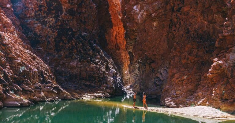
The Ormiston Pound & Gorge Walk is one of Australia’s best day-walks, combining sweeping vistas of the ring of mountains and ridges encircling the 46.5-square-kilometre Ormiston Pound, an up-close geological encounter with the pound’s western floor and a stunning walk through cliff-girt Ormiston Gorge. Ormiston Creek’s waterholes, a refuge for birdlife, mirror the surrounding ochre-red cliffs and the permanent main pool makes for a welcome, if icy, finale on a warm day.
Walk description
The Ormiston Pound & Gorge Walk starts at the Visitor Centre where you’ll find picnic tables and barbeques, toilets, drinking water and even a kiosk. Head north to the nearby walks information shelter from where you might choose to divert left on the paved Waterhole Walk for 5 minutes to capture the gorge colours in early morning light. Otherwise (you’ll finish the walk there in 3 or 4 hours’ time) head east through woodland, following the orange arrows of the Pound Walk anticlockwise, initially coincident with the blue-arrowed Larapinta Trail. The path glances the access road before crossing the bed of Ormiston Creek, lined with venerable river red gums. In 700 metres or so, reach a junction.
Veer left, leaving the Larapinta Trail. After passing a low dry-stone wall (made to block off a false trail), the path undulates and weaves, generally uphill, traversing a succession of red-rock slopes and gullies. A view back to Mt Sonder comes and goes and you may become distracted by the surprisingly luxuriant flora on display, with corkwoods, bloodwoods and red-flowered grevillea featuring along with the ubiquitous spinifex. Some 45 minutes walking should see you onto a saddle at a track junction and a splendid view back whence you’ve come. Detour left on a side path past a ghost gum, ascending to a natural lookout point on a red-rock quartzite ridge.
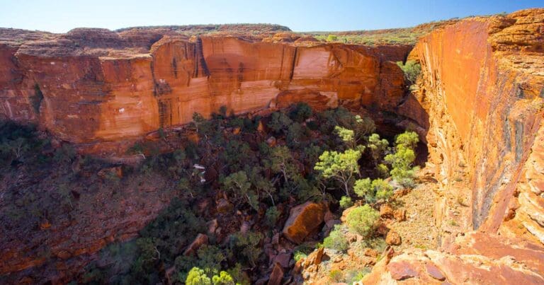
You’ll want to linger awhile to savour the expansive view of Ormiston Pound and its enclosing rock walls, which is first revealed here. To the east of the pound is 1,389-metre Mt Giles, high point of the Chewings Range (and its attendant peaks and ridges), which can be reached and climbed from the pound if you’ve an extra 2 days to spare. To the northwest you’ll see where Ormiston Creek disappears behind a towering rock wall into the confines of the gorge. Beyond is 1380-metre Mt Sonder and much further away, 1531-metre Mt Zeil, the Northern Territory’s highest peak. The area is an important refuge for at least two endangered mammals, not that you’re likely to see them: the central rock rat and the long-tailed dunnart were both rediscovered here in 1997. Return to the track junction on the saddle and descend east. The descent into the pound involves crossing a couple of creek side-gullies and cresting an intervening saddle. Once in the pound the track swings northwest, and you descend gradually through acacia and bloodwood with an understorey of mullamulla and spinifex to reach the sandy bed of Ormiston Creek. Head left downstream, leaving the waymarked track, to a series of rocky waterholes and the shade of some stately river red gums – a perfect lunch spot.
The track shortcuts a big meander in the creek but it is more fun to take the longer route and follow the wide, sandy creek bed downstream. You’ll pass several more tree-lined waterholes and some interestingly patterned bedrock as you negotiate the creek sands for almost a kilometre, directly approaching the now prominent rock that marks the left entrance to the gorge. Reach the point where the waymarked track crosses the creek bed. Here leave the creek left, ascending the left bank, the stony track shortcutting another loop in the creek. The rock views improve as you’re drawn inexorably towards Ormiston Gorge’s narrow entrance.
Cross to the creek’s right bank once more beside several lovely ghost gums. Once in the shady confines of the gorge, things get really interesting and you shouldn’t rush through. There are occasional sandy sections but much easy rock-hopping and boulders to scramble around. The rock underfoot varies enormously: some is jagged, recent cliff-fall, much is water-smoothed in tones of red, purple-grey and orange. Further in there are layered slabs of bedrock and glowing red-rock walls towering up to 250 metres high with gravity-defying ghost gums sprouting at unlikely angles from narrow shelves. All of this is brilliantly reflected in the gorge’s waterholes which, depending on the season, you may be able to skirt without wet feet. Keep an eye out for birdlife: zebra finches, painted finches, dusky grass-wrens and herons are frequent visitors. Skirting a large waterhole, arrive at the signed junction with the Ghost Gum Walk.
You might choose this longer (1 hour) alternative route back to the Visitor Centre, involving a climb to a lookout and then a descent back to water level, but you’d forego some of the finest gorge scenery. It’s a 15 to 20-minute scramble on multi-hued rock shelving that protrudes into the gorge and sometimes on beach sand to reach the last waterhole, lying directly below Ghost Gum Lookout which can be spied above. Herons roost on the lower cliff shelves that flank this waterhole. You should be able to squeeze around rock on the left to a sandy beach which makes a great launch site for that icy swim you’ve earned. Cross to the creek’s right bank below the pool and follow either of the two nearby sets of steps to the end of the paved Waterhole walk where it’s a 5-minute walk back to the Visitor Centre. If camping overnight, make a point of reprising the Waterhole Walk near dusk not just for the lighting but for your best chance to spot the area’s black-flanked rock-wallabies and dingos.
Text in this section and main image taken from the guide book, Best Walks of the Red Centre, courtesy and copyright © Woodslane Press, John & Gillian Souter.
Track Grade
Grade 3 (Moderate) - Walks for Most Fitness Levels: Grade 3 on the AWTGS represents moderate walking tracks. These are ideal for walkers with some fitness who are comfortable with some hills and uneven terrain. While suitable for most ages, some bushwalking experience is recommended to ensure a safe and enjoyable experience. Tracks may have short, steep hill sections, a rough surface, and many steps. The total distance of a Grade 3 walk can be up to 20 kilometers.
Tips
- The best time to walk the trail ( i.e. coolest weather) is between May and August.
- This is a remote area trail. Help takes time to organise and arrive
- Carry an PLB or satellite phone
- Carry enough water and protect yourself from the sun
- Temperatures can rise to the high forties in summer
Map and GPX file
Max elevation: 794 m
Min elevation: 658 m
Total climbing: 362 m
Total descent: -362 m
Trail Location (trailhead)
Sorry, no records were found. Please adjust your search criteria and try again.
Sorry, unable to load the Maps API.
Getting there
Drive 47km west of Alice Springs on Larapinta Drive, turn right onto Namatjira Drive and drive for 81km, then turn right and drive 7km to Ormiston Gorge carpark and campsite.
Photo gallery
If you have any photos from this hike and are happy to share them, please upload your .jpg files here.
Please note: Uploading photos does not transfer ownership of copyright away from you. If requested, you will be credited for any photos you provide and can ask they be deleted at any time.
About the region
Tjoritja West MacDonnell National Park stretches for 161 kilometres west of Alice Springs. Explore and appreciate the scenic beauty and history of the area on foot, swim in a waterhole, or pitch a tent for a longer stay. Take a dip in the cold waters of one the park's permanent water holes. The larger water holes include Ellery Creek Big Hole, Ormiston Gorge, Redbank Gorge and Glen Helen Gorge.
There are numerous marked walking tracks ranging from leisurely to adventurous. The 223 kilometre Larapinta Trail stretches through the park and offers extended and overnight bushwalks for fit, experienced and well prepared walkers. The park encompasses an ancient landscape sculpted over time by climatic elements. It is also a refuge for rare and threatened plants as well as wildlife, including the uncommon bird species such as the Peregrine Falcon.
Features of the landscape are significant to the Arrernte people, including the Ochre Pits that have long been a quarry for important ochre pigments. There are plenty of places to camp in the park, with varied access and facilities. Camping fees apply and overnight visitors should bring their own water supplies. Commercial facilities are available at Glen Helen Resort.
Similar trails nearby
Explore Safe
While planning your hike, it’s important to check official government sources for updated information, temporary closures and trail access requirements. Before hitting the trail, check local weather and bushfire advice for planned burns and bushfire warnings and let someone know before you go. Plan ahead and hike safely.
Let someone know
Adventure with peace of mind: Fill out your trip intentions form. Before you hit the trail, fill out an online form to privately send important details about your hike to your family or friends. If you don’t return on time, they can easily alert emergency services, preventing worry and ensuring a swift response. Hike with peace of mind and enjoy your outdoor adventure to the fullest. Be smart, be safe: Register your plans here.
Gear to consider
What you carry in your pack will depend on the weather, terrain, time of year, type of adventure, and personal preferences. Having trouble deciding what gear’s right for you? My free planning, food and packing checklists provide an introduction to things your could consider (as well as the Ten Essentials) on your day, overnight and multi-day adventures. Customise your kit according to your personal needs, always considering safety first.
Suggest an edit
Trail changed? New features discovered? Has the route changed? Trail permanently closed? Help fellow hikers by suggesting edits! Click above to update route descriptions, GPX file, trail features (like boardwalks), or access conditions (like parking availability). Help me keep the trails info fresh!
Weather
Acknowledgement of Country
Trail Hiking Australia acknowledges the Traditional Owners of the lands on which we hike and pay respects to their Elders, past and present, and we acknowledge the First Nations people of other communities who may be here today.


