AllTrails is a community-sourced platform that seeks to help outdoor enthusiasts access trail guides and maps for hiking, camping, and running. AllTrails claim is you can explore 300,000 hand-curated trail maps plus reviews and photos crowdsourced from millions of hikers, mountain bikers and trail runners.
AllTrails provide a mobile app that claims it turns your phone into a GPS activity tracker so you can follow your trail so you don’t get lost. You can also load crowdsourced routes onto your mobile device to follow routes generated by others. These features sound appealing and as a result, AllTrails has exploded in popularity. Almost to the point where you can’t have a discussion about navigation without someone mentioning it.
At first glance AllTrails seems to be a worthy application that provides a great deal of value to users, I’ve had too many reports from people, raising concern over the reliance on AllTrails. I thought it was time to dig a bit deeper and explore these issues and discuss some of the better alternatives that are out there.
Most seasoned hikers, myself included, will say your smartphone should ‘not be’ used as your ‘primary’ navigation tool. I agree with this but I am not about to argue the point with the thousands of hikers who use them. I use a smartphone app as a backup as they are handy for quickly finding your location on a trail, provided you have offline maps.
My recommendation, if you are going to use your phone as a navigation tool, always carry a map and compass or GPS and know how to use them. It’s also my recommendation you always have two reliable navigation aids as the risk of solely relying on one device is not worth taking. If your battery goes flat, or your electronic device is lost or damaged, you could find yourself in a world of trouble.
Issue #1: Inaccurate information
One of the biggest complaints I receive about AllTrails is that all the data they provide is crowd-sourced. AllTrails state the platform has over 300,000 hand-curated trail maps. The impression this gives unsuspecting users is that the AllTrails team have actually hand-checked and verified every trail you can access. This is not the case as the trails are curated by users.
This provides the company the ability to get its users to generate a huge database of trails from around the world and then pay to access them. It also means that as no one has verified the data is correct, there are loads of inaccurate trails and related information. Performing a quick search for hikes in the Lerderderg State Park, I found a whole heaps of inaccuracies:
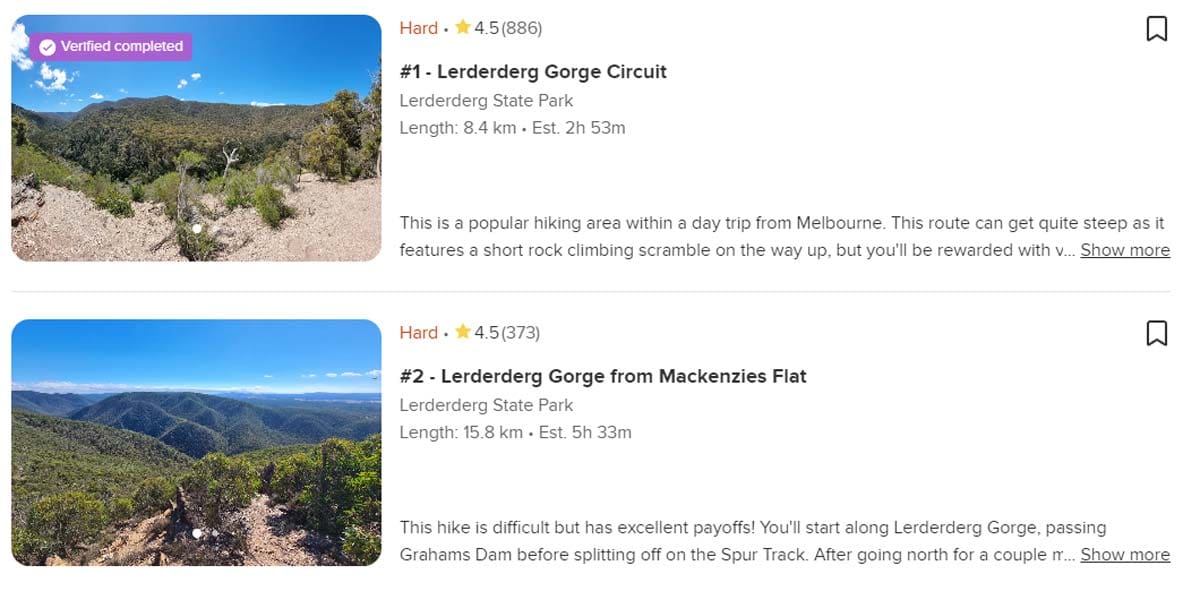
For example, check the following screenshot of ‘trails’ located in the Lerderderg State Park in Victoria. Do you know what all of these have in common as officially recongised trails? They don’t exist, even though one says ‘Verified complete’. Verified by who?
- The first hike, ‘Lerderderg Gorge Circuit‘ is officially called ‘Link 1 and 2 Circuit Walk‘. When viewing the map the user has uploaded, it also traverses a section of Link 2 track that does not exist. They completely missed the official trail that breaks off the spur about three quarters of the way down.
- The second hike ‘Lerderderg Gorge from Mackenzies‘ Flat is officially called ‘The Scenic Rim‘. The hike information states and average walking time of 5.5 hours yet for most people, this circuit will take around 7 hours to complete.
 While these observations may seem trivial, the risk of this misinformation is very real. I am a volunteer with an SES unit that is local to this park. For seven weeks in a row during 2022, Police and SES were called to search for and and rescue lost hikers in the gorge. All of them were using AllTrails and all of them had either followed a route that did not exist, had trusted the time and grade of the hike, or their batteries had become depleted meaning they could not continue back to their vehicles.
The above two examples are loop hikes that utilise existing trails, but rather than call them by their official names, the users who submitted them assigned arbitrary names to the hikes. Why is this a problem? Consider a scenario where something goes wrong and you need to rely on search and rescue crews to get you out. If you are fortunate enough to get a mobile signal to call 000, or left a plan with a family member or friend who contacts emergency services, the name of the trail is often the key to locating you. Instead, the 000 dispatcher is told that you’re on the ‘Lerderderg Gorge Circuit’. This trail name doesn’t exist and its quite possible to complete a circuit of the gorge using a network of different trails. So, the search and rescue crews have no idea where to start looking.
On one of the calls for assistance mentioned earlier, search and rescue crews were told the group of hikers were on Spur Track in the Lerderderg. Now there is an official trail with that name in the park that is well known to local crews (and is on every map) but after hours searching along this spur in the middle of the night, the group could not be located. The police helicopter was deployed and managed to locate the group a few kilometres further into the gorge. They were indeed on a spur, but the name of the spur is Long Point Spur and the trail on this spur is ‘Long Point Track‘. Five hours later, the group were returned to their vehicles but not before putting their life and the lives of rescue crews at risk.
And you guessed it, or maybe you didn’t, they were using AllTrails and were following the randomly named ‘Lerderderg Gorge from Mackenzies Flat‘ hike, that is officially known as ‘The Scenic Rim‘.
These issues with crowdsourced data are not limited to Australia and can occur anywhere AllTrails is used.
Issue #2: Unofficial trails
AllTrails doesn’t limit user submissions to the official, maintained trails. You’re free to record any old GPS track and throw it up for public access. The problem with this is that there is absolutely no distinction between an official trail and an unofficial trail, which may be anything from a well-worn, easy-to-follow path to a complete off-trail bushwalk. Now this might be ok if there was plenty of detailed information about the hike and the key safety information was accurate, but it often isn’t.
For hikers who aren’t accustomed to this, who trust in the limited information available and who aren’t expecting to be walking off the official trail system, this is dangerous and irresponsible.
The unintended consequence often results in people heading into areas that are outside their level of experience and skill, with a false sense of security that they’re hiking on a well marked and official trail and can easily find their way. I’ve had many people report that the trail they were following in the app passed through a closed reference area, private property or through private pine plantations and they were ordered off by the property owners. On some occasions, having to spend a few more hours than intended walking back along public roads.
I’ve also had people report that they thought the hike would be easy, as the user who uploaded it said it would be, but it tuned out to be the most grueling hike they had done. This brings me to my next concern.
Issue #3: Incorrect grade
The Australian Walking Track Grading System is a nationally consistent system to grade the level of difficulty of the track walking experience and then to clearly communicate that information to walkers. Under the system, walking trails are graded on a difficulty scale from grades one to five.

- Grade One (all abilities) is suitable for people with a disability with assistance
- Grade Two (easy) is suitable for families with young children
- Grade Three (moderate) is recommended for people with some bushwalking experience
- Grade Four (hard) is recommended for experienced bushwalkers, and
- Grade Five (difficult) is recommended for very experienced bushwalkers
The challenge with grading trails is that the system for determining a grade is complex and requires a multi-criteria analysis based on the ‘average’ trail users. There is actually an official spreadsheet where you can enter information relating to each criteria to determine the final grade. The grading system is not based on how easy or hard you felt it was and can change based on seasons.
For example, what might be recognised as a Grade Four hike during Autumn can easily become a Grade Five hike during winter when the trails are covered with snow. I have spoken with AllTrails users to understand how they grade the trails they upload. I know I am probably generalising here as I have not spoken with all users, but for the most part, the grade they applied was based on how hard or easy it was for them.
I’ve seen trails uploaded to AllTrails that are in fact the same hike but users have assigned different names, times and grade with some saying ‘easy, 3 hours’ and other ‘hard, 6 hours’. They are probably the same people who email me to say a hike I have listed as grade 4 is an easy grade 3 and I have it all wrong as they smashed the time out of the park. I go by the numbers, not how good you think you might be.
There appears to be not logic or analysis of how the ‘average person’ would cope on any particular trail and no analysis of length, terrain, steepness, signage, navigation requirements or technical skills required. Incorrect hike names, personal (rather than expected) times, unofficial trails, and incorrect grading of hikes can and does lead people into unexpected danger that all too often leads to extraction by search and rescue crews.
Issue #4: Encourages complacency
Hiking with AllTrails is increasingly common. Unfortunately, some people think it’s a magical tool that will keep them from getting lost – Unfortunately, that is far from the reality. While hiking is a relatively safe outdoor activity, it is only safe if you are prepared and know how to navigate. The key to any successful hike is knowing where you are going, where you have been and how to return safely. The most common cause of ill-fated hiking trips is people getting lost and this is often a result of poor planning.
This raises a matter that is not specifically related to mobile phone apps but navigation in general. Not knowing the actual names of the trails you’re using, hikes you’re undertaking or what topography looks like on a map is dangerous from a safety and self-reliance perspective. It’s a lot harder to successfully navigate a trail or network of trails when you don’t know what they’re called, cannot determine how steep or challenging the terrain might be, cannot determine how long the hike will take, and cannot identify the names of individual trails to those who ask. Iv’e seen so many people following a dot on their phone without any knowledge of what trail they are on, and frankly it scares me.
My wife and I were on a hike one day when we came across a group at a junction of three trails at around 3pm. The trails were clearly signposted but the group appeared confused. After a few minutes, they started heading down a trail that I knew was a dead end so I casually asked what hike they were doing. “Not sure of the name but we are following this one on AllTrails“, was the reply. I knew they hike they were doing so pointed them in the right direction and I also pointed out that to complete that hike from our current location would take 5 hours at a reasonable pace. The AllTrails app said the hike would only take 3 hours (and that was from the start, 1.5 hours behind us). After a short debate and a bit of pride being damaged, they conceded it might not be the best idea to continue and headed back the way they came.
The most honest advice I can offer is, if you don’t know how to read a topographic map, use a compass or navigate a hiking trail using aids other than a phone app, then stop to consider the hikes you plan to undertake as some hikes will require more advanced navigation knowledge and technical skill that is often not communicated effectively via platforms like AllTrails. Having someone in your group with an app on their phone is really not enough. Every member of the groups needs to be able to return from every hike as if they were hiking solo. We all need to start every hike with the knowledge that we are personally in control of making it back safely.
So, what’s the alternatives?
I realise at this point I probably sound like I’m just opposed to modern advances in technology, but that’s not the case at all. For all hikes I do, I actually use my smart phone and/or a hand held GPS for a quick update on my current position but I always plan my hikes using a scaled topographical map and I always carry a map and compass in my pack as my primary navigation tool.
There are a lot of apps out there, some good, some not so good. Everyone has different preferences so I won’t tell you which one I think is best but I will recommend a few that don’t share the same issues users experience with AllTrails.
I am a huge fan of technology provided it improves peoples safety.
So, what’s the alternatives to AllTrails? Here’s handful of trail navigation apps I’ve used, in no particular order of recommendation.
I’m keen to hear what ones you like and why.









Completely I share your opinion. It is excellent idea. I support you.
Hi Darren,
Until recently, I too always had a paper map and compass. (And for the first half or so of my walking life, that’s all there was anyway.) The batteries never run out and they still work when wet. But now I use only a phone (plus PLB, plus backup battery, plus plastic bags to put my phone in). Why? Because on some very long hikes (Hume and Hovell, Bibbulmun) the large number of maps will significantly add to the weight (not that you have to carry them all at once – change them at food drops) and, perhaps more importantly, I want to reduce the amount of paper (ie trees) that I use. (Well, yes, a phone plus backup battery is not impact free. But the number of maps I’m not buying is quite significant, and the phone is doing much else besides.) I’m careful about battery life (I’ve never come even close to running my modest backup battery down even over 9 – 10 days). And my phone screen will respond to touch even through a thick plastic bag. Didn’t have a problem even on an all-day deluge on the Bibbulmun – I was soaked, but even though I checked my position several times, the phone was dry (as was everything in my rucksack). Recently used on a couple of wet days in New Zealand, again with no problem.
To be fair. I’m mostly walking on well marked trails which anyone with navigation experience and landscape sense could, if forced, probably walk without a map, or in areas that I know well enough to navigate much by memory (Snowies, Namadgi).
As for AllTrails, I’ve never used it. I use Avenza sometimes for maps in the GeoTiff format, but mostly I use AlpineQuest Lite with OpenTopoMaps, and I download the relevant area together with a gpx file of the route onto my phone storage before I set off, With pre-stored maps, GPS (location) turned on only when I need it, and the phone in flight mode, navigation uses very little battery.
The other thing to remember is that apps like AllTrails trap you into only focusing on that trail that you want to walk. Having a proper map allows you to adjust your plans quickly in the event of an emergency or otherwise. On a solo hike I did a while back, having the physical paper map meant that I always knew what alternative routes I could take, as well as warning of poor trail conditions when wet (which was especially relevant with rain passing nearby). In addition, it allowed me to plan bugout ‘routes’ for if a bushfire occured and I was forced to go bush in order to flee (could be summed up as: Dash down the hill as fast as I could to reach the relative safety of a river, or run up the hill to where a chopper can rescue me).
I am confused. You don’t like AllTrails because the data is crowdsourced and can’t be trusted? But important data on Trailhiking website is also crowdsourced and unverified for example you ask people to contribute GPX files and photos and trails – so how do we know we can we trust Trailhiking? And other sections of the website appears to be auto-generated by some sort of AI, like the address of the start of the trail and the directions, and I’ve noticed many of these are somewhat misleading.
Surely it is better to go direct to the source for the most up to date and accurate information? Read the Vic Parks information on their website. That’s the primary source.
Hi Petra, very valid questions. At least 99% of the GPX files that are on my site are from hikes I have done personally. From time to time, people have uploaded a GPX file for me to include but to be honest, this is very rare and to date, I have only had a handful uploaded by others. Whenever people do send me a GPX file, I cross check the route against both online and topographic maps to ensure that it is an actual trail and they they remained on the trail. It is time consuming to do this, but also very important. I also do the same if any users upload a trail. If it’s an official trail, I’ll give it the correct name, if it’s an unrecognised trail, I’ll research the area first to be certain the information can be verified. With regards to AllTrails, people can just upload whatever they want and the data is never verified. Hope that helps clarify.
To your comment about the start points being generated by AI. I wish it were that easy. Maybe it is? I haven’t used AI so I’m not sure what it’s capable of. Iv’e spend thousands of hours in front of my computer over the past few years, locating the start points, extracting the longitude and latitude for every hike and creating spreadsheets so I can easily import the data. Sometimes I get it wrong so if you know of any that you think are incorrect, please feel free to suggest an edit so I can correct it. I can assure you that everything on this website has been verified by me before it is published.
Regarding going direct to the source. I always recommend people research multiple sources, such as the Parks Vic website that you mentioned. The challenge with them is that they often have very limited information. I spoke with Parks Vic a few years ago about syncing information and working together but they told me the information I have is much better than their data so I’d be better off continuing the way I am.