Hike at a Glance
Max elevation: 1682m
Min elevation: 643m
Total Ascent: 2688m
Important info
This walk is rated as difficult (Grade 5) and includes a mix of well-marked trails and remote, lightly trekked wilderness. To complete it, you must be in good physical condition, well-prepared, and have strong navigation skills. There is limited water availability along the trail, so you will need to carry sufficient water or be knowledgeable about water sourcing.
Hike overview
he Viking Circuit is a challenging yet rewarding hike, offering some of the best alpine scenery in Victoria. Located in the Alpine National Park, northeast of Melbourne, it takes you through diverse landscapes, from well-marked tracks to rugged wilderness. Notable landmarks like the Crosscut Saw, Mount Buggery, Horrible Gap, Mount Despair, The Viking, and Mount Speculation highlight the trek's beauty and difficulty. This Grade 5 hike requires solid navigation skills, particularly on unmarked sections, and tests both endurance and technical skill.
Spanning approximately 41 km over three to four days, the hike involves a significant elevation gain of around 2,700 meters. It is physically demanding, especially with a full pack, requiring immense stamina for long days of hiking. The route passes near Mount Howitt, crosses the Crosscut Saw to Mount Speculation, and continues through Mount Despair and The Razor before finally ascending the prow of The Viking. From there, it descends to the Wonnangatta River, with the final leg involving a return via the Wonnangatta Spur and Zeka Track to your starting point.
Alternatively, the hike can be completed in reverse, starting at the Mount Howitt Car Park and following the Zeka Spur Track down to the Wonnangatta Valley before ascending The Viking and retracing the route back to the high plains. Regardless of the direction, the Viking Circuit features some of Australia’s most challenging terrain, making it suitable only for experienced hikers and confident navigators.
The hike is typically completed over four days, covering significant distances and elevation changes each day. For a smoother start, consider driving up the day before your hike and camping at the Howitt Plains car park. The last two hours of the drive are on an unsealed road often riddled with potholes, so you should plan for a slower journey. If you arrive with enough daylight, you might consider beginning the hike early and spending your first night at the Vallejo Gantner Hut at Macalister Springs. Here is an outline of the journey if starting from the Mount Howitt Car Park.
Stage 1: Mount Howitt Car Park to Mount Speculation
Distance: ~12.5 km
Terrain: High alpine ridges and rocky spurs.
From the Mount Howitt Car Park, the trail climbs steadily to the High Plains. You will soon reach the junction near Mount Howitt, where you join the famous Australian Alps Walking Track (AAWT).
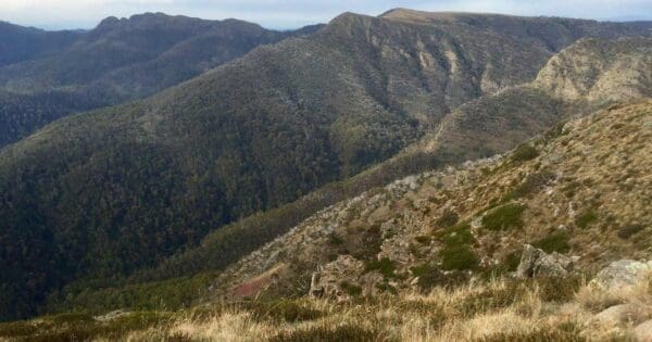
- The Crosscut Saw: This is the highlight of Stage 1. You will traverse this jagged, undulating ridgeline that offers panoramic views of the Terrible Hollow to your east.
- Mount Buggery & Horrible Gap: Don’t let the names discourage you, but be prepared for a steep, knee-jarring descent into Horrible Gap followed by a sharp, punchy climb up Mount Buggery.
- Mount Speculation: The stage concludes with a final climb to the summit of Mount Speculation. This is widely considered one of the best campsites in Victoria, offering a 360-degree view of the route ahead.
Stage 2: Mount Speculation to Vikings Saddle
Distance: ~9 km
Terrain: Remote wilderness, dense scrub, and technical rock scrambling.
This stage takes you off the more defined trails and into the Razor-Viking Wilderness Zone.
- Catherine Saddle: From Speculation, you descend steeply toward Catherine Saddle. The track becomes much more "informal" here; keep a close eye on the red line on your map as navigation can become tricky in poor visibility.
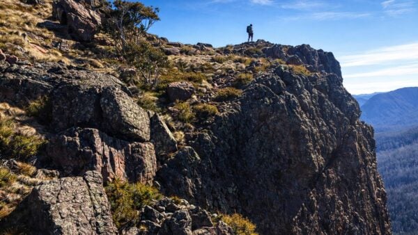
- The Razor: You will traverse the narrow, rocky spine of The Razor. This section requires careful footwork and occasional light scrambling.
- The Viking: The final ascent for the day is up the "prow" of The Viking. There is a famous chimney/rock cleft here where you may need to haul your pack up separately.
- Vikings Saddle: After soaking in the views from the summit, you descend to the heavily forested Vikings Saddle to set up camp. Water is often scarce here, so plan accordingly.
Stage 3: Vikings Saddle to Wonnangatta River
Distance: ~8.5 km
Terrain: Steep, sustained descent and river navigation.
This stage is defined by a massive loss in elevation as you drop from the high peaks down to the valley floor.
- South Viking: The route continues over South Viking before beginning the long trek down and unnamed spur.
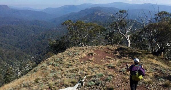
- South Viking (Unnamed) Spur: This is a physical test for the knees. The spur is long, often dry, and can be overgrown with thick scrub depending on recent fire history or regrowth.
- Wonnangatta River: As the spur flattens out, you arrive at the Wonnangatta River. This provides a refreshing change of scenery and a reliable water source. You will find campsites along the river flats, which are a welcome relief after the exposed high-country ridges.
Stage 4: Wonnangatta River to Mount Howitt Car Park
Distance: ~11 km
Terrain: Long valley walk followed by a massive, grueling ascent.
The final day begins with a flat section before the "sting in the tail"—the climb back to the start.
- Wonnangatta Spur: You will follow the river valley for a time before beginning the long, relentless climb up the Wonnangatta Spur.
- Devils Staircase: The map shows the route ascending through the "Devils Staircase." This lives up to its name, requiring significant effort to regain the elevation lost the previous day.
- Zeka Spur Junction: You will eventually intersect with the tracks near Clover Plain.
- Return to Car Park: The final leg takes you past the Mount Howitt area once more, closing the loop. The terrain levels out as you make the final push back to the Mount Howitt Car Park.
Important information
Before setting out, it is essential to be fully aware of the harsh and unpredictable conditions of the High Country. This hike takes place in a true alpine environment where weather can shift violently within minutes, ranging from blistering heat to life-threatening cold or snow, even in summer. Because phone reception is almost non-existent throughout the circuit, carrying a Personal Locator Beacon (PLB) is a non-negotiable safety requirement. You must also ensure that a reliable emergency contact is aware of your specific route and intended return time.
Navigation represents the primary challenge of the Viking Circuit, as roughly half of the trail is either entirely unmarked or poorly defined. This trek is strictly suited for confident navigators who are comfortable using a map and compass or GPS in dense scrub. Furthermore, as this route traverses a protected Wilderness Zone, dogs are strictly prohibited, and you should plan your group logistics accordingly.
Water management is another critical factor for success, as reliable sources are scarce. There are generally only four dependable spots to refill: the spring north of Vallejo Gantner Hut, Camp Creek located about 500 meters north of Mount Speculation, a small creek roughly 500 meters east of Vikings Saddle, and the Wonnangatta River itself. It is imperative to plan your daily water intake carefully, as the ridges between these points are notoriously dry and exposed.
Trail conditions fluctuate significantly as you progress through the loop. The initial track from the Mount Howitt Car Park to Mount Howitt is well-maintained and straightforward. From there to Mount Speculation, the Australian Alps Walking Track is technically unmarked but remains relatively easy to track along the ridgeline. However, once you move beyond Mount Speculation, the trail deteriorates into a true wilderness route with only occasional yellow triangular markers to guide you. The descent from The Viking toward the Wonnangatta Valley is particularly taxing, as there is no defined trail and only intermittent signs of previous footfalls. While the Zeka Spur Track is a clear, active 4x4 road, the old Zeka Track is heavily overgrown and remains one of the most difficult sections to navigate, often taking experienced hikers over four hours to negotiate.
The Viking Circuit offers an unforgettable adventure through some of Victoria’s most rugged and wild landscapes. It remains an ideal choice for those seeking a serious physical and mental challenge, provided you arrive well-prepared, properly equipped, and confident in your ability to find your way through the wilderness.
Track grade
Grade 5 (Difficult) - Walks for the Most Experienced: Grade 5 represents the most challenging walking tracks on the AWTGS. These are only recommended for very experienced and fit walkers with specialised skills, including navigation and emergency first aid. Tracks are likely to be very rough, very steep, and unmarked. Walks may be more than 20 kilometers. These challenging walks demand a high level of fitness and experience to navigate difficult terrain, significant elevation changes, and potentially unformed paths.
Walk map and GPX file
Max elevation: 1682 m
Min elevation: 643 m
Total climbing: 2688 m
Total descent: -2688 m
Content use
Please don’t copy GPX files or content from this site to AllTrails or other platforms. Each trail has been personally mapped, documented, and refined to support Australia’s bushwalking and hiking community. While some details come from land managers, every listing reflects significant personal effort. This is a free, community-driven initiative—your respect helps keep it that way.
Getting there
Getting to the trailhead: Alpine National Park.
To access the Viking Circuit, you will need a vehicle, preferably one with high clearance. From Melbourne, the most direct route is via Licola. Once you reach Licola, stay to the left at the bridge junction to join Tamboritha Road; do not cross the bridge. This road is sealed for the first section as it passes various bush camps, eventually transitioning into a gravel surface. Continue for 48 km until you reach Arbuckle Junction, then turn left onto Howitt Road. Follow Howitt Road for the final 37 km to reach the Mount Howitt car park. Note that this final stretch can be rough and slow-going depending on recent weather and road maintenance.
Need a rental car to get you to the hike? Find one here.
Access conditions
- 4WD Access
- Gravel Road
- Steep Road
- Winding Road
- Large Car Park
- Accessible Parking
- Public Toilets
Find a place to stay
Wondering where to stay near this hike? Find accommodation close to the trailhead — hotels, cabins and campgrounds nearby. Click the button to view the interactive map.
Closest towns to this walk: Benalla, Bright, Dinner Plain, Falls Creek, Harrietville, Hotham Heights, Mansfield, Mitta Mitta, Mount Beauty, Mount Hotham, Myrtleford, Omeo, Porepunkah, Tawonga South, Wangaratta
Let someone know
Heading out? Fill in a trip intentions form so someone knows your plans. If things go wrong, they can raise the alarm fast, giving you peace of mind on the trail.
About the region
The Alpine National Park is a vast protected area spanning the Central Highlands and Alpine regions of Victoria, Australia. Encompassing 646,000 hectares northeast of Melbourne, it stands as the largest national park in the state. The park protects much of the higher reaches of the Great Dividing Range, including Victoria's highest peak, Mount Bogong, which rises to 1,986 metres, as well as the unique subalpine woodlands and expansive grasslands of the Bogong High Plains. To the northeast, the park’s boundary runs along the New South Wales border, where it connects with Kosciuszko National Park to form a continuous alpine wilderness.
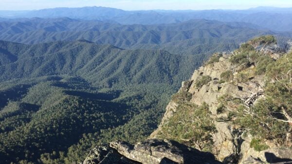
A defining feature of the park's southern section is the Razor-Viking Wilderness Zone, which the Viking Circuit traverses. This area is managed to remain as unaffected by human intervention as possible, prioritizing natural processes and deep solitude. Consequently, hikers will find no signposts, bridges, or formal trail markers within this zone. This wilderness designation is a key reason for the circuit's challenging navigation and its reputation for providing a raw, pristine experience where self-reliance is essential. The combination of deep valleys and high-altitude ridgelines within this protected zone creates some of the most remote and demanding landscapes in the country.
Similar walks nearby
Looking for more walks in or near Alpine National Park? Try these trails with a similar difficulty grade.
Explore safe
Plan ahead and hike safely! Carry enough water, pack layers for changing conditions, and bring safety gear like a torch, PLB, and reliable communication device. Check official sources for trail updates, closures, and access requirements, and review local weather and bushfire advice. Most importantly, share your plans with someone before you go. Being prepared makes for a safer and more enjoyable hike! Stay Safe, Explore More, and Always #ExploreSafe.
Packing checklists
What you carry in your pack depends on factors like weather, terrain, and your adventure type. Not sure what to bring? My free planning, food, and packing checklists are a great starting point, covering day hikes, overnight trips, and multi-day adventures. Use them to customise your kit and always prioritise safety.
Suggest an edit
Notice something different about this trail? Whether it’s a new feature, a route change, or a closure, share your update so we can keep our info accurate and helpful for fellow hikers.
Click to suggest edits >>
Acknowledgement of Country
Trail Hiking Australia acknowledges the Traditional Owners of the lands on which we hike and pay respects to their Elders, past and present, and we acknowledge the First Nations people of other communities who may be here today.
/The-Viking-Circuit-Hike_16.jpg)
/The-Viking-Circuit-Hike_104.jpg)
/The-Viking-Circuit-Hike_94.jpg)
/The-Viking-Circuit-Hike_99.jpg)
/The-Viking-Circuit-Hike_76.jpg)
/The-Viking-Circuit-Hike_107.jpg)
/The-Viking-Circuit-Hike_3.jpg)
/The-Viking-Circuit-Hike_57.jpg)
/The-Viking-Circuit-Hike_12.jpg)
/The-Viking-Circuit-Hike_103.jpg)
/The-Viking-Circuit-Hike_32.jpg)
/The-Viking-Circuit-Hike_46.jpg)
/The-Viking-Circuit-Hike_87.jpg)
/The-Viking-Circuit-Hike_23.jpg)
/The-Viking-Circuit-Hike_4.jpg)


3 Reviews on “The Viking Circuit Hike (41km)”
We completed the cct over the Melbourne Cup long weekend. There were quite a few groups doing the cct both clockwise and counterclockwise. We completed it clockwise and there were well over 30 people doing the same. Counter clockwise there were about 10 that I was aware of + plenty doing the out the Viking saddle and return with everybody meeting on night 2 at Viking Saddle. (It was a very busy campground.) This walk is rated 5 and rightly so, it is a hard walk, you will need a base level of hiking fitness to complete the loop. You will need more food than usual, I took my normal hike menu and could have done with a bit more and left a few KGs of myself on the track. You will need more water than usual if it is hot, I found I needed an extra litre per day over what I normally use. The track well defined from Howitt Car Park to before the decent before the Viking Saddle camp ground, On the decent there is several hundred meters of tree fall. So think three large Moutain Ash lying on top of each other continuously. you cannot go around as it pushes you into the gully so you have to climb up and log walk to stay over the track It took most groups about 1.5 hours to move through the tree fall and it was energy zapping. From the Viking to the spur line leading to the Wonnangatta river the track fades in and out so you will need to know how a map relates to the terrain to follow the path. Now to the Zeka Track. Once you leave the road, the track does not exist as everybody has stated. Even with all the foot traffic there was only a vague trail forming. So this is pushing through bush making about 1 to 1.5 KMH progress, but for me it was worth it, plenty of wild flowers and the views on the loop returned in this section. Given the alternative of staying on the road and having a 300m decent and climb back up again I would choose the bush path . For me I have always wanted to do the cct and was so glad I took notice of the reviews and had mentally prepared myself for the walk ahead. If you decided to do this as an out and back as some recommend you still have a 4 day hard hike as the return path is as hard as it was going in. So just prepare yourself for this hike and you will experience one of the best 4 days hikes that you will ever do. At Cup Weekend Good Water was at Mac Springs, Camp creek and Viking Saddle.
Wow, that’s a lot of people out there. I’ve done this circuit a couple of times and have never seen another soul. Hope it didn’t take away from the remote experience. Sounds like you really enjoyed the hike which is fantastic given you’ve always wanted to do it. Thanks heaps for the update on the trail conditions.
Started from Mt Howitt carpark clockwise, There is water at camp creek currently (March 2023), would recommend taking the “Speculation road” from lower camp creek to Catherine Saddle in 2023, We didn’t, day 2 we started from upper camp creek, was tough to get through that section along the Aus alpine hiking track, no path was found at any point, very heavy brush on a slope. Maybe even consider camping at lower camp creek if you are feeling a bit sore on day 1.
Not sure if there is water at Viking saddle.
Very hard. Amazing views. Pack as light as you can, lots of up and down.
Talked to somebody who made it from Mt Speculations to Viking and back in a day with a day pack another time, this could be an option with an early start, lets you skip Zeka Spur track but need to be very fit.
Patricia Pringlez
Patrick Cooley
Pepper Carroll
Phil Hunter
Rodney how are your navigation skills?
Short by 60k and no ‘Bastard’ in it
Shunyo James
Shayne Gillings get on it
That section of the hike has always and will probably always be over grown simply due to the number of people who attempt this hike. It is only for experienced hikers (not necessarily foolhardy). It is the only route you can take to complete the circuit.
Sascha Hovens ok! Next hike after the lake!
Suzie Sharp one for when I get all of my overnight gear?
There is a section so dense we averaged 1.5k for 6 hours. if you could run the whole thing I will shave off all my hair
Thijs Baarda
Three hard, full days. A lot of people choose to do it in four for this reason.
Samuel Jc…good times
Suzie Sharp it’s only 10kms per day so what’s the problem ??
Romana Hoffman
Spring is a good time as it is more likely that there will be water around.
A good training walk for us Bev Gaylene
Aaron ?
Adam. This looks great.
Adeline Dickson
Alan Dow
Amy Brown let’s set a weekend maybe in November??
Andrew Chau – another “lazy hike” to talk the ladies into for a long weekend?
Angelo Garlitos
Any update on the Viking Saddle to Wonnangatta River section as per tien nguyen’s comments on 1 February 2017? Heavy undergrowth and blackberries seem to rule this route out except for the most adventurous, or foolhardy.
April Watson
Brenda Belfield 🙂
Cameron Forrest
Chris Smith quite possible.i would have to have a look at map first. in general i want to do all great alpine hike
Could just run it and be done in 6hrs
Craig Grant
Craig Thomas Irvine
Damian Hess
done! i’m up for some trail inspiration.
Alicja Alice I like the sound of this….think we could do in 2 days! ?