Navigating by the Sun: A guide for hikers in Australia
Australia’s vast and diverse landscape offers a multitude of hiking trails, providing opportunities to explore stunning natural wonders. While traversing these trails, hikers may encounter situations where they need to navigate without the aid of maps or GPS devices. Understanding how to utilise the sun’s position can be an invaluable skill for such situations.
The sun’s path in Australia
Unlike at the equator, where the sun rises and sets directly due east and west respectively, in Australia, the sun’s path varies throughout the year. This variation is due to the Earth’s tilt and inclination relative to the sun. As a result, the sun rises and sets at different angles throughout the year, with the exact angle depending on the latitude and the time of year.

Determining latitude using the sun
As hikers, we often find ourselves in remote areas, far from the familiar landmarks and technological aids that we rely on in our daily lives. In these situations, it can be helpful to know how to navigate using the natural world around us. One such method is to use the rising and setting of the sun to determine our approximate latitude.
How it works: The Earth’s axis is tilted at an angle of 23.5 degrees relative to the plane of its orbit around the sun. This tilt causes the sun’s position in the sky to vary throughout the year. At the equinoxes, an event that occurs twice a year, the sun is directly overhead at the equator. At the solstices, the sun is directly overhead at the Tropic of Cancer (June solstice) or the Tropic of Capricorn (December solstice). There are two types of solstices: summer solstices and winter solstices. Summer solstices occur around 21 June in the Northern Hemisphere and 21 December in the Southern Hemisphere. Winter solstices occur around 21 December in the Northern Hemisphere and 21 June in the Southern Hemisphere. The angle between the sun and the horizon at any given time depends on the observer’s latitude and the time of year. This angle is called the solar altitude.
- Measuring Solar Altitude: To measure solar altitude, you need a tool that can measure angles. One such tool is a clinometer. A clinometer is a small, handheld instrument that has a bubble level and a protractor. To use a clinometer, hold it up to your eye so that the bubble level is centered. Then, point the protractor at the sun. The angle between the sun and the horizon will be displayed on the protractor.
- Determining Latitude: Once you know the solar altitude, you can use it to determine your approximate latitude. There are a few different ways to do this. One method is to use a table of solar altitudes for different latitudes and times of year. Another method is to use a calculator that is programmed to do this calculation.
- Estimating Latitude: If you don’t have a clinometer or calculator, you can still make a rough estimate of your latitude by observing the rising and setting of the sun. At the equinoxes, around 20 March and 22 September each year, the sun rises and sets due east and due west, respectively. At the solstices, the sun rises and sets at an angle away from due east and due west. The greater the angle, the farther the observer is from the equator. The accuracy of this method depends on the time of year and the observer’s ability to estimate the angle of the sun. In general, the method is more accurate at the equinoxes and less accurate at the solstices.
While this method may seem confusing and is not as accurate as using a GPS device, it can be a valuable tool for hikers who find themselves in remote areas without access to technology. By observing the rising and setting of the sun, hikers can get a ‘rough idea’ of their latitude and make informed decisions about their route.
Determining direction using the sun
Despite the variation in its path, the sun’s position can be used to determine direction, especially in the absence of other navigational aids. Here are two methods for using the sun to navigate:

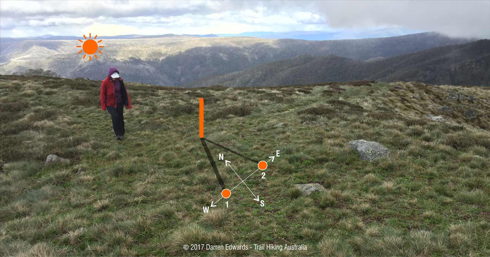
1. Navigating by the sun: Shadow stick method
This method is simple and effective, particularly in the Southern Hemisphere, where the sun’s movements are more predictable.
- Find a straight stick or branch approximately 1 meter long.
- Choose a level spot free of obstructions where the stick will cast a clear shadow.
- Insert the stick vertically into the ground at the chosen spot.
- Mark the tip of the shadow with a stone, twig, or other visible marker. This mark represents your western direction.
- Wait for approximately 10-15 minutes for the shadow to move a noticeable distance.
- Mark the new tip of the shadow. This mark represents your eastern direction.
- Draw a line connecting the two marks (west and east). This line approximates an east-west line.
- To determine north, stand with the west mark to your left and the east mark to your right. You are now facing north.
The accuracy of the shadow stick method depends on several factors, including the time of day, the season, and the latitude. In general, the method is more accurate in the Southern Hemisphere than in the Northern Hemisphere, and it is most accurate around noon. Here’s some additional factors that can affect the accuracy of the shadow stick method:
- Cloud cover: If there is cloud cover, it can be difficult to see the shadow clearly. This will make it difficult to accurately measure the shadow’s length and direction.
- Uneven terrain: If the ground is uneven, the shadow will not be straight. This will make it difficult to accurately measure the shadow’s length and direction.
- Error in placing the stick: If the stick is not placed vertically in the ground, the shadow will not be accurate.
Despite its limitations, the shadow stick method is a simple and effective way to determine direction in the wilderness. It is a good skill to have in your tool kit, especially if you are planning to hike in an area where maps or GPS devices are unavailable.

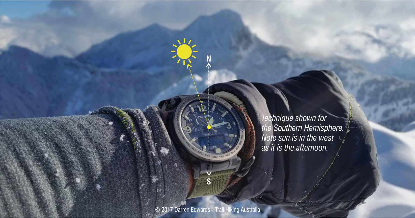
2. Navigating by the sun: The watch method
The watch method is a simple and effective way to determine direction using an analog watch, especially when maps or GPS devices are unavailable. This method works best in the Northern Hemisphere, where the sun’s movements are more predictable. However, it can also be used in the Southern Hemisphere with some modifications.
Equipment: An analog watch with hour and minute hands.
Steps
- Set the watch to the correct time: Ensure your watch is set to the correct local time. If you are unsure of the local time, you can try to synchronise your watch with the sun’s position.
- Position the watch: Hold the watch flat in your palm or lay it on a flat surface. The watch face should be facing up.
Determining Direction
Southern Hemisphere:
- Align the 12 o’clock mark with the sun: Rotate the watch until the 12 o’clock mark on the watch face is pointing directly towards the sun.
- Find the midpoint: Draw a line bisecting the angle between the 12 o’clock mark and the hour hand. This line represents the north-south line.
- Identify north and south: The end of the line closer to the 12 o’clock mark indicates south, while the end closer to the 6 o’clock mark indicates north.
- Note: If your watch is set on daylight savings time, use the midway point between the hour hand and 1 o’clock to determine the north-south line.
Northern Hemisphere:
- Align the hour hand with the sun: Rotate the watch until the hour hand on the watch face is pointing directly towards the sun.
- Bisect the angle: Draw a line bisecting the angle between the hour hand and the 12 o’clock mark. This line represents the north-south line.
- Identify north and south: The end of the line closer to the 12 o’clock mark indicates north, while the end closer to the 6 o’clock mark indicates south.
If there is any doubt as to which end of the line indicates north, remember that the sun rises in the east, sets in the west, and is due south at noon. The sun is in the east before noon and in the west after noon.
Additional Considerations:
- Time of Day: The accuracy of this method is highest around noon when the sun is at its highest point in the sky. As the day progresses, the sun’s position changes, and the accuracy of the method decreases.
- Seasonality: The sun’s path varies throughout the year, so the accuracy of this method may be affected by the time of year. In general, the method is more accurate during the summer months when the sun is higher in the sky.
- Cloud Cover: Clouds can obscure the sun, making it difficult to accurately determine its position.
The watch method is a simple and practical technique for determining direction when maps or GPS devices are unavailable. While it may not be as precise as other methods, it can provide valuable guidance in wilderness settings. However, it is always advisable to use multiple navigational techniques whenever possible to ensure accurate and safe navigation.


