Trail Fast Facts
Wet Tropics Great Walk is an 70km, grade 5 hike in Girringun National Park, Queensland. The walk should take around 5-6 days to complete.
Warning
Be aware that estuarine crocodiles may be encountered in waterholes, creeks and rivers along the Great Walk. Crocodiles can be dangerous. Do not take unnecessary risks and remember to be croc wise in croc country.
Hike Overview
The Wet Tropics Great Walk is a challenging yet rewarding adventure for experienced hikers. Located within Girringun National Park, Queensland, this 70km challenging trek (grade 5) from Wallaman Falls to Henrietta Gate takes approximately 4-6 days to complete.
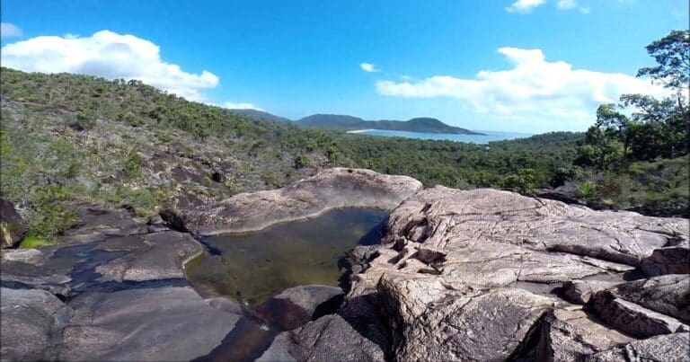
The Wet Tropics Great Walk offers breathtaking scenery. Tackle overnight camping amidst stunning waterfalls, plunging gorges, and inspiring vistas. The Wallaman Falls Section is a great introduction to the region's beauty. For seasoned hikers, the wilderness trails of Juwun and Jambal, venturing through the Herbert River Gorge, provide an unforgettable challenge.
The Wet Tropics Great Walk traverses the magnificent Wet Tropics World Heritage Area. This region is home to the Traditional Aboriginal Custodians who maintain a deep connection to the land. Walkers can choose from various experiences, from short strolls to multi-day adventures.
Highlights Along the Way:
- Begin your journey at Wallaman Falls, Australia's tallest single-drop waterfall.
- Keep an eye out for shy wildlife like platypus and southern cassowary.
- Immerse yourself in the diverse Wet Tropics of Queensland World Heritage Area and Einasleigh Uplands bioregion.
- Take a detour for half-day adventures offering stunning views of the Gorge and Blencoe Falls.
The Wet Tropics Great Walk promises a challenging yet enriching experience for those seeking to explore the wonders of Girringun National Park and the Wet Tropics World Heritage Area.
The track notes are written from the Wallaman Falls end. Reverse the notes if starting from either Henrietta gate or Yamanie pick-up points. If you begin at Henrietta Gate or Yamanie pick-up points, reverse the directions accordingly.
Day 1: Wallaman Falls to Pack Trail Campsite (23km)
Your journey begins at Wallaman Falls, following an old forestry track through diverse landscapes. Expect she-oak woodlands, open forests, and pockets of rainforest teeming with ferns and palms. Keep an eye out for vibrant Ulysses butterflies flitting through the foliage and forest kingfishers perched on branches.
Around the 5km mark, you'll encounter a large clearing, once a forestry quarry. The landscape is slowly recovering, and this scar will eventually disappear. Further along, remnants of an old forestry camp stand as a testament to the area's past. Garrawalt Creek, 7.2km further, provides a perfect lunch spot. Look closely in the rock pools for a glimpse of a platypus or hear the splash of a water dragon entering the stream.
After lunch, you'll cross three more creeks. Fill up your water containers at Flagstone Creek, the last water source for nearly 14km. Continue for another 4.4km to reach your overnight destination, Pack Trail campsite.
Day 2: Pack Trail Campsite to Yamanie Campsite (13km)
Today's walk offers a glimpse into the past as you traverse a section of the Dalrymple Track, built in the 1860s by George Dalrymple for transporting supplies. Be prepared for a steep descent on uneven terrain. Take a break halfway down to enjoy panoramic views across the Herbert River Valley.
At the base of the hill, you'll pass through a large scrubby gully. This is where the Buujan Quiinbiira walk diverges for the Yamanie Campsite. You can walk directly to the campsite or continue along either side of Herbert River to explore further along Yamanie Trail.
The Yamanie Trail section offers a pleasant walk through open forest along the Herbert River's high banks. Keep your eyes peeled for wildlife like noisy scaly-breasted lorikeets or the deep call of the wompoo fruit-dove. Look for pockets of riparian rainforest with large fig trees, a testament to changes in soil and moisture levels. You might even spot a platypus in the river or freshwater turtles basking on logs. Remember, crocodiles are present, so only cross the river at designated points.
Day 3: Yamanie Campsite to Stony Creek Campsite (15.5km)
Along this section, keep an eye out for a grove of cycads, ancient plants dating back to the era of dinosaurs. Roughly 4km from Yamanie Turn-off, Garrawalt Creek provides an excellent spot for a rest.
Continue for another 4.4km to reach Stony Creek campsite, where you'll set up camp for the night.
Day 4: Stony Creek Campsite to Henrietta Gate Pick-up Point (18.5km)
Fill up your water bottles before leaving, as there won't be any available for nearly 13km. While some sections may show signs of past grazing and introduced species, this area is crucial habitat for the endangered mahogany glider. Conservation efforts are underway to control these threats.
Stop for lunch and refill your water bottles at Henrietta Creek before tackling the final leg. After another 6km, you'll pass Lemon Tree Gully, named after the resident lemon tree that still bears fruit. Only 5.2km remain until you reach Henrietta Gate, your pick-up point.
Track Grade
Grade 5 (Difficult) - Walks for the Most Experienced: Grade 5 represents the most challenging walking tracks on the AWTGS. These are only recommended for very experienced and fit walkers with specialised skills, including navigation and emergency first aid. Tracks are likely to be very rough, very steep, and unmarked. Walks may be more than 20 kilometers. These challenging walks demand a high level of fitness and experience to navigate difficult terrain, significant elevation changes, and potentially unformed paths.
Tips
- After rain, creeks and rivers along the Great Walk may flood.
- Always check the weather forecast before you begin your walk.
- Watch out for snakes. Though rarely seen, they are always around. Some snakes are more active at night, so always use a torch, wear shoes and watch where you walk.
- Be aware that estuarine crocodiles may be encountered in waterholes, creeks and rivers along the Great Walk. Crocodiles can be dangerous. Do not take unnecessary risks and remember to be croc wise in croc country.
- Water should only be collected from shallow, flowing rapids. Treat water before drinking.
- Only cross the river at shallow areas. Be careful, rocks may be algae covered and extremely slippery.
- Wear sturdy shoes when crossing. Sharp rocks can cause discomfort and bullrouts (freshwater stonefish) live in the river. If stung, seek medical attention.
Map and GPX file
Max elevation: 675 m
Min elevation: 44 m
Total climbing: 999 m
Total descent: -1510 m
Trail Location (trailhead)
Sorry, no records were found. Please adjust your search criteria and try again.
Sorry, unable to load the Maps API.
Getting there
Reaching Wallaman Falls: Three Entry Points
The Wallaman Falls section of the Wet Tropics Great Walk offers access from three distinct locations: Wallaman Falls itself, Yamanie pick-up point, and Henrietta gate pick-up point. All access points are reachable from Ingham. It's recommended to check road conditions with RACQ (www.racq.com.au) before setting off, especially since some sections require four-wheel drive vehicles.
Wallaman Falls Access: This access point is the most straightforward. Located 51km southwest of Ingham, it's roughly a one-hour drive through rural properties. Head west from Ingham on Abergowrie Road until you reach Trebonne. From there, clear signage will guide you. The sealed road allows access by conventional vehicles, though caution is advised on the range due to potential slippery conditions when wet. Towing caravans is not recommended.
Yamanie Pick-up Point: This option is slightly further at 60km from Ingham, translating to a 45-minute drive through rural areas. Follow Abergowrie Road west from Ingham until you reach a gate marking the entrance to Girringun National Park. Remember to close the gate behind you. Beyond this point, a four-wheel drive vehicle is highly recommended.
Henrietta Gate Pick-up Point: This is the most challenging access point, requiring a four-wheel drive vehicle due to the unsealed road. Travel west from Ingham for about 24km on Abergowrie Road. Look out for the second left turn past the Ashton Hotel onto Sheahans Road. Continue for 2.9km, then turn left at the Wet Tropics Great Walk directional sign. Remember to leave all gates as you find them on this route.
While vehicle access exists for specific sections like Dalrymple Gap Track or Wallaman Falls Track, most of Girrungun National Park remains untouched. This rugged terrain is best suited for experienced bushwalkers willing to undertake challenging hikes.
Photo gallery
If you have any photos from this hike and are happy to share them, please upload your .jpg files here.
Please note: Uploading photos does not transfer ownership of copyright away from you. If requested, you will be credited for any photos you provide and can ask they be deleted at any time.
About the region
Nestled in Queensland, Australia, Girrungun National Park boasts a landscape sculpted by time. This World Heritage Site, roughly 50 kilometers southwest of Ingham, offers a true wilderness experience for adventurous travelers. Established in 1994, the park was initially named Lumholtz National Park and later renamed Girrungun in 2003.
Divided into six distinct sections, Girrungun National Park showcases a diverse tapestry of natural wonders. Witness the power and majesty of Wallaman Falls, Australia's highest single-drop waterfall, or feel the spray of Blencoe Falls cascading towards the Herbert River. History buffs can retrace the steps of early European explorers by traversing the 10km Dalrymple Gap walking track. Adventurous hikers can tackle the challenging slopes of Mount Fox, an ancient volcano offering panoramic vistas of the surrounding countryside. Explore Princess Hills, where the Herbert River dramatically plunges over a rockface to form Herbert River Falls. Birdwatchers will delight in observing a diverse array of water birds at the seasonal waterholes and lagoons of Wairuna.
Similar trails nearby
Explore Safe
While planning your hike, it’s important to check official government sources for updated information, temporary closures and trail access requirements. Before hitting the trail, check local weather and bushfire advice for planned burns and bushfire warnings and let someone know before you go. Plan ahead and hike safely.
Let someone know
Adventure with peace of mind: Fill out your trip intentions form. Before you hit the trail, fill out an online form to privately send important details about your hike to your family or friends. If you don’t return on time, they can easily alert emergency services, preventing worry and ensuring a swift response. Hike with peace of mind and enjoy your outdoor adventure to the fullest. Be smart, be safe: Register your plans here.
Gear to consider
What you carry in your pack will depend on the weather, terrain, time of year, type of adventure, and personal preferences. Having trouble deciding what gear’s right for you? My free planning, food and packing checklists provide an introduction to things your could consider (as well as the Ten Essentials) on your day, overnight and multi-day adventures. Customise your kit according to your personal needs, always considering safety first.
Suggest an edit
Trail changed? New features discovered? Has the route changed? Trail permanently closed? Help fellow hikers by suggesting edits! Click above to update route descriptions, GPX file, trail features (like boardwalks), or access conditions (like parking availability). Help me keep the trails info fresh!
Weather
Acknowledgement of Country
Trail Hiking Australia acknowledges the Traditional Owners of the lands on which we hike and pay respects to their Elders, past and present, and we acknowledge the First Nations people of other communities who may be here today.


