Hike at a Glance
Max elevation: 476m
Min elevation: 451m
Total Ascent: 46m
Hike overview
The Wambelong Nature walking track is a delightful 1km hike in Warrumbungle National Park, not far from Coonabarabran. This short but rewarding walk offers plenty for nature lovers, particularly those keen on birdwatching and wildlife spotting. The trail, graded 3, can be completed in around 45 minutes, making it a perfect option for a leisurely stroll through one of New South Wales' most stunning landscapes.
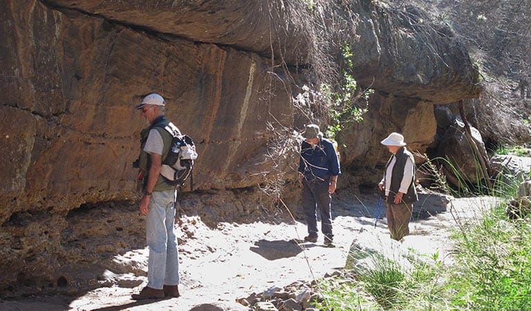
Starting at Canyon picnic area, the track follows Wambelong Creek, winding through a small, sheltered gorge. As you walk, you’ll be surrounded by unique rock outcrops and dramatic spires that have been shaped by volcanic forces over millions of years. The landscape feels ancient and timeless, providing an ideal backdrop for a peaceful escape into nature. As you take in the expansive views, keep your eyes peeled for brown falcons soaring above or red-winged parrots flitting through the trees.
The track gradually rises, offering an awe-inspiring perspective of the valley below and Split Rock. It’s a beautiful spot to pause and appreciate the vastness of the park. Along the way, you might catch a glimpse of some of the park’s iconic wildlife. Koalas are known to make their homes in the treetops, while emus can often be seen darting through the bush. During the hotter part of the day, kangaroos take shelter in the shade near Camp Wambelong, adding to the charm of this peaceful walk.
Whether you're an avid birdwatcher or simply seeking a tranquil hike, the Wambelong Nature walking track provides a perfect opportunity to connect with the wildlife and natural beauty of Warrumbungle National Park.
Gallery
Got some great shots from this hike? Upload your photos here to inspire others and show off the beauty of the trail!
Click to view form >>
Submitting your photos doesn’t mean you lose ownership. You can be credited for your contributions, and you can request removal at any time.
Content use
Please don’t copy GPX files or content from this site to AllTrails or other platforms. Each trail has been personally mapped, documented, and refined to support Australia’s bushwalking and hiking community. While some details come from land managers, every listing reflects significant personal effort. This is a free, community-driven initiative—your respect helps keep it that way.
Walk map and GPX file
Max elevation: 476 m
Min elevation: 451 m
Total climbing: 46 m
Total descent: -45 m
Getting there
Getting to the trailhead: Warrumbungle National Park.
Wambelong Nature walking track starts from Canyon picnic area in the central precinct of Warrumbungle National Park. To get there: Travel along John Renshaw Parkway from Coonabarabran. Upon entering the park, take the turn-off to the visitor centre. Continue along the road to Canyon picnic area Parking Parking is available at Canyon picnic area.
Closest towns to this walk: Baradine, Binnaway, Coolah, Coonabarabran, Dunedoo, Gilgandra, Gulargambone, Mendooran
About the region
Millions of years ago, a mighty shield volcano sculpted the jagged peaks of Warrumbungle National Park. Today, these ancient formations rise majestically from eucalyptus-dotted plains, creating a landscape unlike any other in New South Wales.
As Australia's first Dark Sky Park, Warrumbungle boasts pristine skies untouched by light pollution. Here, the Milky Way stretches across the heavens, revealing a dazzling display of stars, planets, and distant galaxies. Whether you're a seasoned astronomer or a curious beginner, Warrumbungle offers unforgettable stargazing experiences.
Lace up your boots and explore a network of walking tracks. Hike the iconic Breadknife and Grand High Tops Walk for breathtaking close-up views of the park's most recognizable rock formations. The park is a haven for outdoor enthusiasts, with opportunities for camping, birdwatching, and capturing stunning photographs of the dramatic scenery.
While wildfires impacted the park in 2013, the National Parks and Wildlife Service (NPWS) has meticulously restored walking tracks, campgrounds, and visitor facilities. Start your adventure at the Warrumbungle Visitor Centre, where you can gather park information or purchase a star chart to navigate the night sky.
Similar walks nearby
Looking for more walks in or near Warrumbungle National Park? Try these trails with a similar difficulty grade.
Track grade
Grade 3 (Moderate) - Walks for Most Fitness Levels: Grade 3 on the AWTGS represents moderate walking tracks. These are ideal for walkers with some fitness who are comfortable with some hills and uneven terrain. While suitable for most ages, some bushwalking experience is recommended to ensure a safe and enjoyable experience. Tracks may have short, steep hill sections, a rough surface, and many steps. The total distance of a Grade 3 walk can be up to 20 kilometers.
Explore safe
Plan ahead and hike safely! Carry enough water, pack layers for changing conditions, and bring safety gear like a torch, PLB, and reliable communication device. Check official sources for trail updates, closures, and access requirements, and review local weather and bushfire advice. Most importantly, share your plans with someone before you go. Being prepared makes for a safer and more enjoyable hike! Stay Safe, Explore More, and Always #ExploreSafe.
Packing checklists
What you carry in your pack depends on factors like weather, terrain, and your adventure type. Not sure what to bring? My free planning, food, and packing checklists are a great starting point, covering day hikes, overnight trips, and multi-day adventures. Use them to customise your kit and always prioritise safety.
Let someone know
Before heading out, take a moment to fill out your trip intentions form. It’s a quick way to share your hike details with family or friends. If something goes wrong, they can notify emergency services, ensuring a faster response and peace of mind. Stay safe and enjoy your adventure
Suggest an edit
Spotted a change on this trail? Maybe there are new features, the route has shifted, or the trail is permanently closed. Whatever the update, I’d love your input. Your feedback helps fellow hikers stay informed and ensures that our trail info stays fresh and reliable.
Acknowledgement of Country
Trail Hiking Australia acknowledges the Traditional Owners of the lands on which we hike and pay respects to their Elders, past and present, and we acknowledge the First Nations people of other communities who may be here today.


