Hike at a Glance
Max elevation: 885m
Min elevation: 105m
Total Ascent: 2090m
Important info
The Lerderderg State Park is rugged and remote with limited directional signage. You should be prepared for all conditions and have suitable navigation experience (not just a phone app) before venturing beyond the main picnic/parking areas or Grahams Dam. Many rescues have occurred in this park that could have been avoided.
Hike overview
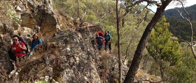
The Lerderderg Track extends from Daylesford to Bacchus Marsh starting from Bridport Street Lookout, spanning a distance of 89 kilometers. It serves as a shared pathway for both mountain bikers and pedestrians, showcasing some of Melbourne's most rugged and untamed landscapes. Designated as a Heritage River, the Lerderderg holds significance for its diverse vegetation, abundant wildlife, and unique geological formations within its deep gorge.
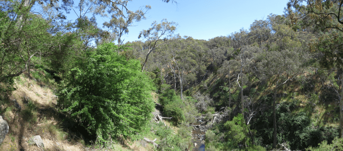
Forming part of the Great Dividing Trail Network, the Lerderderg Track is the southeastern segment, complementing the 210-kilometer Goldfields Track from Mt Buninyong to Bendigo. The initial section of the track winds through tall eucalypt forests, gradually transitioning as it follows the Lerderderg River through a steep valley, culminating in a breathtaking gorge.
Journeying southward, travelers observe a decline in rainfall, leading to changes in vegetation from lush fern-lined riverbanks to dry stringybark forests. The track also offers glimpses of ancient geological formations dating back 300 million years when Australia was part of the Gondwana supercontinent.
The Lerderderg Track is divided into seven distinct Walks/Rides, each offering unique experiences and landscapes. From Bridport Lookout, routes like the Graves Mill Walk/Ride and Balt Camp Walk/Ride lead adventurers through historical sites and diverse ecosystems. However, some sections, like Simmons Reef Walk/Ride and Whisky Creek Walk/Ride, pose challenges due to terrain and closures for environmental preservation.
As travelers approach Bacchus Marsh, the track navigates through suburban expansion, with signage updates planned to facilitate easier navigation. Directions to Bacchus Marsh railway station involve a route through Ramsay Cres, Halletts Way, and Maddingley Park, as detailed on the Lerderderg Track map.
Content use
Please don’t copy GPX files or content from this site to AllTrails or other platforms. Each trail has been personally mapped, documented, and refined to support Australia’s bushwalking and hiking community. While some details come from land managers, every listing reflects significant personal effort. This is a free, community-driven initiative—your respect helps keep it that way.
Walk map and GPX file
Max elevation: 885 m
Min elevation: 105 m
Total climbing: 2090 m
Total descent: -2514 m
Getting there
Getting to the trailhead: Lerderderg State Park.
Getting to Lake Daylesford, Victoria, is a straightforward journey. From Melbourne, take the Western Freeway towards Ballarat and exit at Daylesford. Follow the Midland Highway into town, where signs will guide you to the lake. The drive takes approximately 90 minutes, making it an easy day trip or a relaxing weekend getaway. For those relying on public transport, V/Line trains run from Southern Cross Station to Woodend or Ballan, with connecting bus services to Daylesford. Once there, the lake is within walking distance of the town centre, offering a peaceful retreat surrounded by picturesque scenery and inviting walking trails.
Closest towns to this walk: Bacchus Marsh, Ballan, Blackwood, Bullengarook, Coimadai, Darley, Daylesford, Gisborne, Kyneton, Macarthur, Macedon, Maddingley, Melton, Myrniong, Sunbury, Trentham, Woodend
About the region
Rising in the Great Dividing Range, the Lerderderg River has cut a 300 metre deep gorge through sandstone and slate, almost bisecting the park. The park has a wide variety of vegetation and wildlife and some interesting relics of gold mining. Lerderderg State Park encompasses scenic and geological gorge formations surrounding the Lerderderg River as well as the volcanic cone of Mount Blackwood. The adjacent and separate block called the Pyrete Range forms part of the park. The Lerderderg is known for its remote setting and the 300m deep Lerderderg River gorge is a dominant feature. Private land abuts the park to the south and the Wombat State forest abuts to the north and west.
Lerderderg State Park (incorporating the former Pyrete State Forest) is a 14,250-hectare park located between Bacchus Marsh and Blackwood, an hour's drive from Melbourne, Australia. There are several maintained tracks for walking through the park and camping is allowed.
The park is named for the Lerderderg River which has cut the 300 metre deep Lerderderg Gorge through sandstone and slate, almost bisecting the park. Parks Victoria maintains six designated walks: three short walks of 3.5 km or less; Blackwood-O'Briens Crossing and return (22 km); O'Briens Crossing-Cowan Track loop (14 km); and the overnight walk O'Briens Crossing to Mackenzies Flat (20 km).
In addition, one leg of the Great Dividing Trail, the Lerderderg Track, passes through the park, entering from Blackwood in the park's northwest, and exiting south towards Bacchus Marsh. Bicycles are prohibited from one section of this track, due to a conservation area.
Similar walks nearby
Looking for more walks in or near Lerderderg State Park? Try these trails with a similar difficulty grade.
Track grade
Grade 3 (Moderate) - Walks for Most Fitness Levels: Grade 3 on the AWTGS represents moderate walking tracks. These are ideal for walkers with some fitness who are comfortable with some hills and uneven terrain. While suitable for most ages, some bushwalking experience is recommended to ensure a safe and enjoyable experience. Tracks may have short, steep hill sections, a rough surface, and many steps. The total distance of a Grade 3 walk can be up to 20 kilometers.
Explore safe
Plan ahead and hike safely! Carry enough water, pack layers for changing conditions, and bring safety gear like a torch, PLB, and reliable communication device. Check official sources for trail updates, closures, and access requirements, and review local weather and bushfire advice. Most importantly, share your plans with someone before you go. Being prepared makes for a safer and more enjoyable hike! Stay Safe, Explore More, and Always #ExploreSafe.
Packing checklists
What you carry in your pack depends on factors like weather, terrain, and your adventure type. Not sure what to bring? My free planning, food, and packing checklists are a great starting point, covering day hikes, overnight trips, and multi-day adventures. Use them to customise your kit and always prioritise safety.
Let someone know
Before heading out, take a moment to fill out your trip intentions form. It’s a quick way to share your hike details with family or friends. If something goes wrong, they can notify emergency services, ensuring a faster response and peace of mind. Stay safe and enjoy your adventure
Suggest an edit
Spotted a change on this trail? Maybe there are new features, the route has shifted, or the trail is permanently closed. Whatever the update, I’d love your input. Your feedback helps fellow hikers stay informed and ensures that our trail info stays fresh and reliable.
Acknowledgement of Country
Trail Hiking Australia acknowledges the Traditional Owners of the lands on which we hike and pay respects to their Elders, past and present, and we acknowledge the First Nations people of other communities who may be here today.
/Great-Dividing-Trail-Lerderderg-Track_10.jpg)
/Great-Dividing-Trail-Lerderderg-Track_7.jpg)
/Great-Dividing-Trail-Lerderderg-Track_5.jpg)
/Great-Dividing-Trail-Lerderderg-Track_8.jpg)
/Great-Dividing-Trail-Lerderderg-Track_11.jpg)
/Great-Dividing-Trail-Lerderderg-Track_13.jpg)
/Great-Dividing-Trail-Lerderderg-Track_3.jpg)
/Great-Dividing-Trail-Lerderderg-Track_17.jpg)
/Great-Dividing-Trail-Lerderderg-Track_2.jpg)
/Great-Dividing-Trail-Lerderderg-Track_6.jpg)
/Great-Dividing-Trail-Lerderderg-Track_19.jpg)
/Great-Dividing-Trail-Lerderderg-Track_9.jpg)
/Great-Dividing-Trail-Lerderderg-Track_15.jpg)
/Great-Dividing-Trail-Lerderderg-Track_4.jpg)
/Great-Dividing-Trail-Lerderderg-Track_14.jpg)


