Trip Report by Mark D – July 2018
The 5P’s of Planning and Getting to Wilson’s Prom
The Wilson’s Promontory – South Eastern Circuit was to be my first overnight hike in 20 years AND I was going solo (Madness!)
5p’s (Proper Planning Prevents Poor Performance)
- Transport to Wilsons Promontory (WP). Car is the only option, no public transport will get you closer than Fish Creek (55km away). Park in Overnight Visitors carpark at Tidal River and hike to Telegraph saddle carpark or just park at Telegraph Saddle (I did!). I hired a car from Rent-a-Bomb for ~$23 a day.
- Water. Water was everywhere. Every camp has access to a creek or tank water. All should be treated – I boiled mine, but did meet people who just drank direct from streams.
- Food. Everything is packed in. Some food is available at Tidal River, but limited and pricey.
- Shelter. All campsites are booked in advance, bring your own everything. About $13.50 per person per night. Pay this and don’t cheat – this helps pay for all the work at WP and there is a LOT done to make these trails accessible. (E.g. the toilet tanks have to be helicoptered in and out).
- Toileting – pit and tank toilets at all campsites and carparks. I took a shovel, never used it. Take your own toilet paper.
- Communications. No mobile phone coverage can be relied on, sometimes, maybe, you get a glimmer of reception, but not good enough for emergencies. I did not take a PLB, probably should have though.
Day 1. Telegraph Saddle to Roaring Meg (RM) campsite
Carpark is well signed for the route leading out – take the Telegraph Track south. This is a gravel road, so pace is quick. 2 hours to Telegraph Junction, then past Halfway Hut campsite about 30 minutes further on. Around 15 minutes past Halfway Hut you can choose to take the walking path to RM or stay on the road. I took the road. Walking path takes about 30 minutes longer.
Roaring Meg has 2 separate parts – Lower RM and Upper RM. Lower RM is where the water access is and is quite secluded but is low ground so quite wet, 3 pads for tents, could fit 5-6 in a pinch. Upper has better access to the toilet, 5 pads for tents, could fit a few more if doubled up on pads. Tables supplied.
Day 1 took about 3 hours hike (guide claims 4), all on road for me. Well signed. 12km
Day 2. Roaring Meg to South Point (SP) + Return
Roaring Meg to Little Waterloo Bay (LWB) campsite via Lighthouse.
Cold night (this campsite is in a valley so the cold just washes over you all night), left tent set up, hike pack in tent and started walking to South Point at ~5am. Got to SP just shy of 6am. (TIP – there is a point where the track may lead you out onto a huge rock with gorgeous views and no obvious track out – just back up a few metres and you will find the trail). Stayed at SP for Sunrise. Cannot get to the very southern tip without braking rules, trampling vegetation and risking becoming trapped – so don’t.
Returned to RM, broke camp and headed out to the Lighthouse via walking track. There is a road option, I recommend the road as there is not much to see on the track and the track just connects to the road anyway. Left all gear at branch to lighthouse and went to lighthouse, worth the trip as there is a flush toilet and decent tank water. Good views and history signs on this part. It is possible to stay here at ~$140 per person per night.
Collected gear and off to LWB – this is a long walk, tight path, hilly, rocky, occasional nice views. There is about a kilometre of beach walking on this section and a nice grate/ramp at the end to put your shoes on / empty your shoes of sand. Take your shoes off and enjoy dry feet and squeaky sand.
About 7.5 hours hike for the day (8.5 on the guide). 25.6km
LWB campsite is back from the beach, 8-10 pads, could fit a few more here and there. Some sites can flood in rain so choose wisely. Water is from the creek, but a piping setup make collection easier. Took a swim (paddle really) and hated on the noisy school group that showed up.
Day 3. Little Waterloo Bay to Sealers Cove (SC), via Refuge Cove
Broke camp ~6am, there is a creek crossing just on the edge of LWB that could leave you wet, or try rock jumping. After a section in the bush the path dumps you onto the beach again just keep walking on the beach until the sign for the path points you back into the bush. There is a side trip up to Mt Kersop here, leave the pack at the branch and some goods views can be had at the summit. Then onto Refuge Cove.
Refuge Cove camp site is the only vehicle accessible site (via boat), so there may be more people here than anywhere else on the trip – I saw no-one. Use the toilet, refill on creek water and head northwest to the track (signs can be somewhat confusing as there are two campsites, hikers and boaties are separated, but you will find the exit on the boaties side)
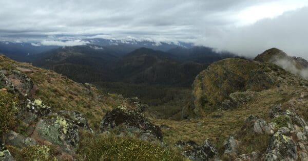
Another short spell in the bush and onto the beach again, then back into the bush again. There is a point where the path comes out onto a rocky area and it is not really clear which way to go, don’t bushbash, the path is northwest (ish) – when you see it you will know. The best views on the section are here so enjoy. Rest of the way has occasional nice views over the ocean and with luck some whale sightings (I saw some).
SC campsite is quite sprawling and room for 15-20 ish tents, creek water via pipe again. There was a completely fearless fox living here when I stayed – would just sit and watch me and the moment I stepped away was scrounging dropped rice grains… Also came sniffing around at night too – scary as in the torchlight when you are all alone – and I was! Mostly – A ranger and friends came through quite late in the day, but they stayed at the rangers hut outside of the campground.
4.5 hours hike for the day, 4.5 in the guide.
Day 4. Sealers Cove to Telegraph Saddle
The original plan was to cross Sealers Creek at low tide, around 11am to minimise water height. The day before when the ranger crossed it was close on high tide and was only up to the top of his legs. So I got bored at around 8am and went for it, water up to mid shin, shoes went back on and on way up the beach. The path from the beach is well signed and the last toilet is here. Boardwalk runs for almost 2km over the swamp. Pace is quick, but be warned – can be slippery and edges can be rotten.
Once the boardwalk ends there is a long, wet, undulating climb to Windy Saddle. Some very picturesque creek crossings (bridged) and waterfalls in this section, also a cave can be seen… Windy Saddle has a couple of tables and there looks to be an unofficial trail up to Mount Ramsay, did not take this option. Last stretch is Windy Saddle to Telegraph Saddle, nicely built path here. Could be wheelchair friendly – it is wide and smooth enough. Path has much signage for the restoration works that Parks Vic and volunteers did to rectify some significant landslides a few years ago. (this is why paying for your site is important)
Reflections and Takeaways
This hike is entirely manageable for a well-prepared, reasonably fit novice — especially one who respects the fundamentals of planning and self-reliance. The Southern Circuit offers a beautiful mix of remote wilderness, quiet beaches, and varied terrain without being overly technical. While I went solo, I never felt unsafe, just isolated enough to feel the depth of the wilderness and to think more clearly than I have in months.
The overnight temperatures were colder than expected — particularly at Roaring Meg, which sits in a valley that traps the cold — so gear rated for lower temps is recommended even in milder seasons. Water was plentiful and accessible at every camp, but should always be treated. Track signage was generally clear, though there were a few moments (especially at rocky junctions or beach exits) where a bit of navigation awareness was necessary.
Wildlife was minimal but memorable — kangaroos, wallabies, a fearless fox, and one stubborn wombat. No snake sightings, although the environment certainly supports them. I was lucky with weather; the hike would be significantly more difficult — and potentially dangerous — in sustained rain or storms, especially on the boardwalk and steep, rooty descents.
I’ll absolutely return, but next time I’ll aim for clearer skies to fully appreciate the views, sunrises, and solitude. Overall, this was more than a hike — it was a reminder that adventure doesn’t need to be far-flung or extreme to be deeply rewarding. The Prom delivers.


Sounds like an interesting trip in one of our favourite parts of Victoria.