Hike at a Glance
Max elevation: 701m
Min elevation: 236m
Total Ascent: 858m
Hike overview
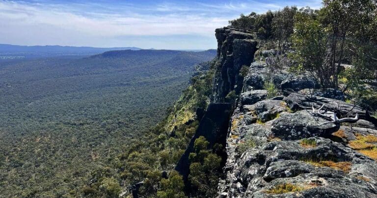
Victoria Arch is a challenging 12 km, grade 5 hike in Grampians National Park, Victoria, and typically takes around six hours to complete. This hike explores an isolated pocket of the Victoria Range Remote and Natural Area, featuring an unusual rock formation that creates an arch, which can be explored and climbed.
The hike begins on the Hutt Creek Track just south of the Hutt Creek crossing on Harrop Track. It follows a rough rock climbers' track most of the way to the Mordor rock climbing wall at the southern end of the maze. Look out for tape and rock cairns that mark the route.
From the road, the trail heads east for a few kilometres before climbing up over the range across open rock slabs and through rock gullies. After leaving the road, the hike becomes entirely off-trail and quite challenging, with dense undergrowth. Once on top of the range, the trail descends to the western edge of the maze, a large rock formation, and follows its western side along a gully. At the end of the maze, the trail follows its high south wall around until its end, then heads north up a rocky gap that is just wide enough for a person.
Enter through the gap, turn right, and continue along the rock until you are directly under the arch. Experienced climbers can ascend the smooth sloping slab under the arch and exit the other side to enjoy views towards Mount Thackeray.
Looking through the arch to the right is a narrow, steep chimney that can be climbed to reach the summit. There are a few obstacles along the way, but once past them, the chimney can be climbed.
Additional Walk - Manja Shelter (2.5km return)
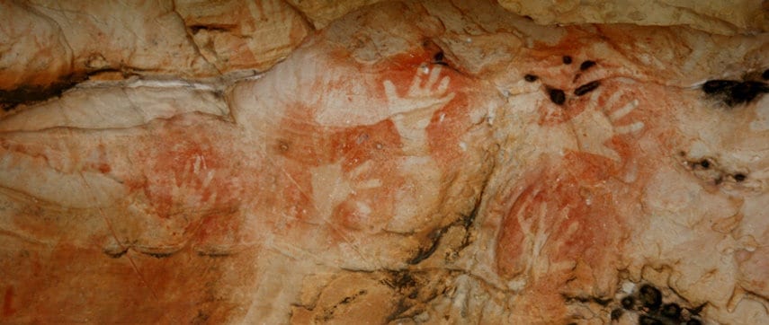
After completing this hike it is well worth heading south approximately 400m along Hutt Creek Track to the Manja Shelter Walk. Manja(pronounced Manya) meaning 'hands', has some of the best examples of hand stencils in Victoria. A total of 90 stencils have been recorded in these two shelters. It is believed that hand stencils were used to record a visit to a site, and to renew the ties a person had to a particular place. At this site there are also animal tracks and many human stick figures. Manja is in an impressive sandstone outcrop. Have a walk around and try to imagine what it would have been like to live here before Europeans arrived.
Refer to route below.
Tips
- The area is a lot more open now after the recent fire a year or so back.
- Good views across to Mount Thackeray and The Fortress.
- This is a remote area so be careful when climbing and do not go beyond your abilities
- The trail is not well defined so ensurure you have good navigation skills
- The GPX file does not necessarily follow any trail markers although there are some along the route. The route is not obvious in many places.
Content use
Please don’t copy GPX files or content from this site to AllTrails or other platforms. Each trail has been personally mapped, documented, and refined to support Australia’s bushwalking and hiking community. While some details come from land managers, every listing reflects significant personal effort. This is a free, community-driven initiative—your respect helps keep it that way.
Walk map and GPX file
Max elevation: 701 m
Min elevation: 236 m
Total climbing: 858 m
Total descent: -856 m
Manja Shelter
Max elevation: 335 m
Min elevation: 243 m
Total climbing: 93 m
Total descent: -93 m
Getting there
Getting to the trailhead: Grampians National Park.
From Melbourne, Follow National Highway M8 and A8 to Wonwondah-Dadswells Bridge Rd in Laharum. Take Northern Grampians Rd/C222 and Brimpaen-Laharum Rd to Henty Hwy/A200 in Brimpaen Turn left onto Henty Hwy/A200 then follow Billywing Rd to Harrops Track
Closest towns to this walk: Ararat, Cavendish, Dadswells Bridge, Dunkeld, Halls Gap, Horsham, Landsborough, Pomonal, Stawell, Warracknabeal, Wartook, Wartook Valley
About the region
Renowned for rugged mountain ranges, rich cultural heritage and breathtaking scenic views, the 168,000 hectare park is ideal for a wide range of outdoor activities. The many walking tracks will take you on a journey to waterfall views, ancient geological rock features and forests. There are guided tours, and with a large network of roads available, car touring is a great way to explore. Renowned as the major attraction in the region, the Grampians National Park is a must-visit destination for all travellers, backpackers and day-trippers in Victoria. The spectacular setting of the mountainous landscape boasts a wide array of attractions and activities for visitors to the region. The Grampians National Park (also Gariwerd), commonly referred to as The Grampians, is a national park in the Grampians region of Victoria, Australia. The 167,219-hectare (413,210-acre) national park is situated between Stawell and Horsham on the Western Highway and Dunkeld on the Glenelg Highway, 260 kilometres west of Melbourne and 460 kilometres east of Adelaide.
Similar walks nearby
Looking for more walks in or near Grampians National Park? Try these trails with a similar difficulty grade.
Track grade
Grade 5 (Difficult) - Walks for the Most Experienced: Grade 5 represents the most challenging walking tracks on the AWTGS. These are only recommended for very experienced and fit walkers with specialised skills, including navigation and emergency first aid. Tracks are likely to be very rough, very steep, and unmarked. Walks may be more than 20 kilometers. These challenging walks demand a high level of fitness and experience to navigate difficult terrain, significant elevation changes, and potentially unformed paths.
Explore safe
Plan ahead and hike safely! Carry enough water, pack layers for changing conditions, and bring safety gear like a torch, PLB, and reliable communication device. Check official sources for trail updates, closures, and access requirements, and review local weather and bushfire advice. Most importantly, share your plans with someone before you go. Being prepared makes for a safer and more enjoyable hike! Stay Safe, Explore More, and Always #ExploreSafe.
Packing checklists
What you carry in your pack depends on factors like weather, terrain, and your adventure type. Not sure what to bring? My free planning, food, and packing checklists are a great starting point, covering day hikes, overnight trips, and multi-day adventures. Use them to customise your kit and always prioritise safety.
Let someone know
Before heading out, take a moment to fill out your trip intentions form. It’s a quick way to share your hike details with family or friends. If something goes wrong, they can notify emergency services, ensuring a faster response and peace of mind. Stay safe and enjoy your adventure
Suggest an edit
Spotted a change on this trail? Maybe there are new features, the route has shifted, or the trail is permanently closed. Whatever the update, I’d love your input. Your feedback helps fellow hikers stay informed and ensures that our trail info stays fresh and reliable.
Acknowledgement of Country
Trail Hiking Australia acknowledges the Traditional Owners of the lands on which we hike and pay respects to their Elders, past and present, and we acknowledge the First Nations people of other communities who may be here today.

/Victoria-Arch-Hike_34.jpg)
/Victoria-Arch-Hike_4.jpg)
/Victoria-Arch-Hike_27.jpg)
/Victoria-Arch-Hike_29.jpg)
/Victoria-Arch-Hike_33.jpg)
/Victoria-Arch-Hike_9.jpg)
/Victoria-Arch-Hike_22.jpg)
/Victoria-Arch-Hike_20.jpg)
/Victoria-Arch-Hike_30.jpg)
/Victoria-Arch-Hike_16.jpg)
/Victoria-Arch-Hike_31.jpg)
/Victoria-Arch-Hike_10.jpg)
/Victoria-Arch-Hike_14.jpg)
/Victoria-Arch-Hike_5.jpg)
/Victoria-Arch-Hike_18.jpg)


6 Reviews on “Victoria Arch Hike (12km)”
Erin!
Alicja Alice. This one is for you
I’ll do this when I finally end up in the Grampians and don’t detour to Newcastle from Whyalla like I did last time ?
Alastair Hyde one for our bucket list ?
Lee Swatton
KC Pom, Kay, a short hike for you and Dave in June.
Kyle Chen
Brendan Spratling Christine O’Halloran this would be a good one, but I’m having trouble getting the GPX file
Sam Dunkley Keen?
Elizabeth Spiteri Grade 5 next time we swing past?
Suzie Sharp
Alexander Ross
Azam Kassim shall we?
Andrew Black one for the list
Tracy Lindsey can you fit this in?
Tara Cameron we should do a good hike
Looks good!
i absolutely love that hike..
Oooooooh that would be good to do and see.
Shannon Lingard xxx life goals
Marjorie Andrea