Trail Fast Facts
The Standley Chasm High Route Loop is a 23km, grade 4 hike in the West MacDonnell National Park, Northern Territory. This hike typically takes 7 hrs to complete.
Warning
Safety should be your first priority when hiking in this region. Careful planning, having the right supplies, plenty of water and knowing your limits are the keys to a trouble free walk.
Hike Overview
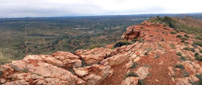
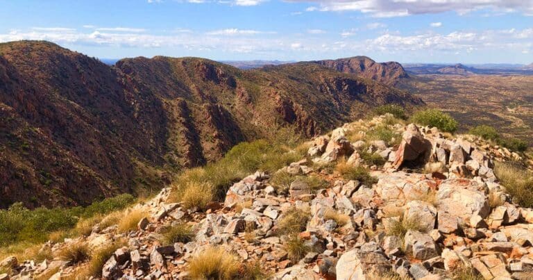
The Standley Chasm High Route Loop is an unofficially circuit that traverses Section 3 of the Larapinta Trail through the magnificent Chewings Ranges. This is quite a challenging walk through some of the steepest and most rugged country in the ranges. It can be completed in one day but a good level of fitness is required. The track is rough with long steep sections.
There are two options for walking Section 3 of the Larapinta: the hard way and the 'easier' way. The hard way involves taking the ‘alternate high route’ which rewards walkers with great views and scenery, but requires some difficult ascents and descents. The standard and easier 'low route' traverses over and through rocky and narrow gorges and creek beds which is not as hard as the high route, but still tough on the feet and ankles. This hike explores both.
Highlights include:
- High route offers great views
- Clambering over boulders and narrow gorges
- Hard steep ascents and descents
- 360 degree views
- Awesome views near Angkale Junction area
Safety: It’s Your Responsibility
Safety should be your first priority when hiking in this region. Careful planning, having the right supplies, plenty of water and knowing your limits are the keys to a trouble free walk.
- The recommended walking season is April to September inclusive, although dangerously hot weather can occur during these months. Do not attempt long walks in hot weather.
- Consider your health and fitness carefully before walking any part of the Trail. Know your limits and have an emergency plan. Allow for flexibility in case of unseasonably hot weather.
- Walk with at least two others so that an injured person is not left alone. Carry some form of emergency communication such as a satellite phone or personal locator beacon (PLB).
- Walkers should leave details of their walk plan with a reliable person. Ensure they know to contact police if you don’t return by the pre-arranged time.
- Fill out the logbooks provided at every Trailhead so that Rangers can track your movements in an emergency.
Track Grade
Grade 4 (Hard) - Challenging Walks for Experienced Walkers: Grade 4 on the AWTGS signifies challenging walking tracks. Bushwalking experience is recommended for these tracks, which may be long, rough, and very steep. Directional signage may be limited, requiring a good sense of navigation. These walks are suited for experienced walkers who are comfortable with steeper inclines, rougher terrain, and potentially longer distances.
Tips
- Fit and experienced walkers
- Rocky, Loose terrain
- Steep in places
- Trail is reasonably well defined
- Limited water, especially during the dry season
Trail features
- Gravel Path
- Sandy Trail
- Rough Trail
- Undefined Trail
- Trail Running
- Rivers
- Gorges
- Exposed Ledges
- Rock Scrambling
- Steep Terrain
- River Crossings
- Scenic Viewpoints
- Untreated Water
Map and GPX file
Max elevation: 1148 m
Min elevation: 749 m
Total climbing: 2035 m
Total descent: -2025 m
Trail Location (trailhead)
Sorry, no records were found. Please adjust your search criteria and try again.
Sorry, unable to load the Maps API.
Getting there
Standley Chasm is about 50km west of Alice Springs and can be accessed by 2WD via the sealed Larapinta Drive. Gates are open between 8am – 5pm. You can leave your vehicle here but you may need to pay a fee to do so. This is a private property. There is a small fee for access to the chasm itself.
Access conditions
- 2WD Access
- Gravel Road
- Entry Fee
- Large Car Park
- Public Toilets
- Drinking Water
- Picnic Shelter
- Picnic Table
About the region
Tjoritja West MacDonnell National Park stretches for 161 kilometres west of Alice Springs. Explore and appreciate the scenic beauty and history of the area on foot, swim in a waterhole, or pitch a tent for a longer stay.
Take a dip in the cold waters of one the park's permanent water holes. The larger water holes include Ellery Creek Big Hole, Ormiston Gorge, Redbank Gorge and Glen Helen Gorge.
There are numerous marked walking tracks ranging from leisurely to adventurous. The 223 kilometre Larapinta Trail stretches through the park and offers extended and overnight bushwalks for fit, experienced and well prepared walkers.
The park encompasses an ancient landscape sculpted over time by climatic elements. It is also a refuge for rare and threatened plants as well as wildlife, including the uncommon bird species such as the Peregrine Falcon.
Features of the landscape are significant to the Arrernte people, including the Ochre Pits that have long been a quarry for important ochre pigments.
There are plenty of places to camp in the park, with varied access and facilities. Camping fees apply and overnight visitors should bring their own water supplies. Commercial facilities are available at Glen Helen Resort.
Similar trails nearby
Explore Safe
While planning your hike, it’s important to check official government sources for updated information, temporary closures and trail access requirements. Before hitting the trail, check local weather and bushfire advice for planned burns and bushfire warnings and let someone know before you go. Plan ahead and hike safely.
Let someone know
Adventure with peace of mind: Fill out your trip intentions form. Before you hit the trail, fill out an online form to privately send important details about your hike to your family or friends. If you don’t return on time, they can easily alert emergency services, preventing worry and ensuring a swift response. Hike with peace of mind and enjoy your outdoor adventure to the fullest. Be smart, be safe: Register your plans here.
Gear to consider
What you carry in your pack will depend on the weather, terrain, time of year, type of adventure, and personal preferences. Having trouble deciding what gear’s right for you? My free planning, food and packing checklists provide an introduction to things your could consider (as well as the Ten Essentials) on your day, overnight and multi-day adventures. Customise your kit according to your personal needs, always considering safety first.
Suggest an edit
Trail changed? New features discovered? Has the route changed? Trail permanently closed? Help fellow hikers by suggesting edits! Click above to update route descriptions, GPX file, trail features (like boardwalks), or access conditions (like parking availability). Help me keep the trails info fresh!
Weather
Acknowledgement of Country
Trail Hiking Australia acknowledges the Traditional Owners of the lands on which we hike and pay respects to their Elders, past and present, and we acknowledge the First Nations people of other communities who may be here today.


