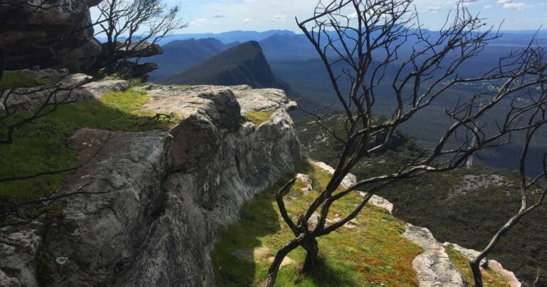
The Mount Sturgeon Loop hike, is a variation of the Mt Sturgeon return hike and is suitable for fit and energetic walkers. It can involve water crossings, slippery track surfaces, rock hopping and steep sections. Follow the path up through open woodland and view endemic montane species such as the Grampians Gum. Several steep sections lead through rocky terrain and stunted vegetation dominates as the track nears the summit. The walk provides panoramic views of the surrounding ranges and volcanic plains over Dunkeld, the gateway to the southern Grampians.
After completing the final climb over Mt Sturgeon (Wurgarri). Take in stunning views out over volcanic plains and the impressive peaks of the southern Grampians. To the north are the sedimentary sandstones of Gariwerd; to the south, basalt lava flows. The landscape reveals stories of country. Volcanoes nearby at Budj Bim National Park and Mt Gambier are only 5000 years old, while the oldest dated Aboriginal rock shelter in Gariwerd is 22,000 years old. Imagine living in a landscape of active volcanoes! Skeletons buried in layers of ash near Warrnambool, and Dreamtime (creation) stories speak to this.
Complete the circuit by steeply descending into farmland below and wandering through open old-growth Red Gum woodland to arrive back at the trail head.
Please don’t copy GPX files or content from this site to AllTrails or other platforms. Each trail has been personally mapped, documented, and refined to support Australia’s bushwalking and hiking community. While some details come from land managers, every listing reflects significant personal effort. This is a free, community-driven initiative—your respect helps keep it that way.
Contributed by John Rymill
Total distance: 6959 m
Max elevation: 579 m
Min elevation: 247 m
Total climbing: 446 m
Total descent: -447 m
Getting there
Getting to the trailhead: Grampians National Park.
Intersection of Grampians Tourist Road and Victoria Valley Road
Closest towns to this walk: Ararat, Cavendish, Dadswells Bridge, Dunkeld, Halls Gap, Horsham, Landsborough, Pomonal, Stawell, Warracknabeal, Wartook, Wartook Valley
About the region
Renowned for rugged mountain ranges, rich cultural heritage and breathtaking scenic views, the 168,000 hectare park is ideal for a wide range of outdoor activities. The many walking tracks will take you on a journey to waterfall views, ancient geological rock features and forests. There are guided tours, and with a large network of roads available, car touring is a great way to explore. Renowned as the major attraction in the region, the Grampians National Park is a must-visit destination for all travellers, backpackers and day-trippers in Victoria. The spectacular setting of the mountainous landscape boasts a wide array of attractions and activities for visitors to the region. The Grampians National Park (also Gariwerd), commonly referred to as The Grampians, is a national park in the Grampians region of Victoria, Australia. The 167,219-hectare (413,210-acre) national park is situated between Stawell and Horsham on the Western Highway and Dunkeld on the Glenelg Highway, 260 kilometres west of Melbourne and 460 kilometres east of Adelaide.
Similar walks nearby
Looking for more walks in or near Grampians National Park? Try these trails with a similar difficulty grade.
Favourite

Favourite

Favourite

Favourite

Track grade
Grade 4 (Hard) -
Challenging Walks for Experienced Walkers: Grade 4 on the
AWTGS signifies challenging walking tracks. Bushwalking experience is recommended for these tracks, which may be long, rough, and very steep. Directional signage may be limited, requiring a good sense of navigation. These walks are suited for experienced walkers who are comfortable with steeper inclines, rougher terrain, and potentially longer distances.
Explore safe
Plan ahead and hike safely! Carry enough water, pack layers for changing conditions, and bring safety gear like a torch, PLB, and reliable communication device. Check official sources for trail updates, closures, and access requirements, and review local weather and bushfire advice. Most importantly, share your plans with someone before you go. Being prepared makes for a safer and more enjoyable hike! Stay Safe, Explore More, and Always #ExploreSafe.
Packing checklists
What you carry in your pack depends on factors like weather, terrain, and your adventure type. Not sure what to bring? My free planning, food, and packing checklists are a great starting point, covering day hikes, overnight trips, and multi-day adventures. Use them to customise your kit and always prioritise safety.
Let someone know
Before heading out, take a moment to fill out your trip intentions form. It’s a quick way to share your hike details with family or friends. If something goes wrong, they can notify emergency services, ensuring a faster response and peace of mind. Stay safe and enjoy your adventure
Suggest an edit
Spotted a change on this trail? Maybe there are new features, the route has shifted, or the trail is permanently closed. Whatever the update, I’d love your input. Your feedback helps fellow hikers stay informed and ensures that our trail info stays fresh and reliable.
/Mount-Sturgeon-Loop-Hike_1.jpg)
/Mount-Sturgeon-Loop-Hike_5.jpg)
/Mount-Sturgeon-Loop-Hike_6.jpg)
/Mount-Sturgeon-Loop-Hike_4.jpg)
/Mount-Sturgeon-Loop-Hike_2.jpg)
/Mount-Sturgeon-Loop-Hike_7.jpg)
/Mount-Sturgeon-Loop-Hike_3.jpg)


