Hike at a Glance
Max elevation: 260m
Min elevation: 50m
Total Ascent: 242m
Important info
Caution: Very steep, paved track that can be slippery. Wear ankle-supporting shoes with good grip.
Hike overview
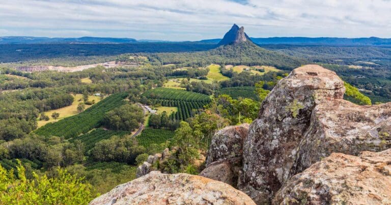
The Mount Beerburrum Summit Walk offers stunning panoramic views of the Glass House Mountains and beyond, but be prepared for a challenging climb. This hike is best suited for those with reasonable fitness due to the steep incline.
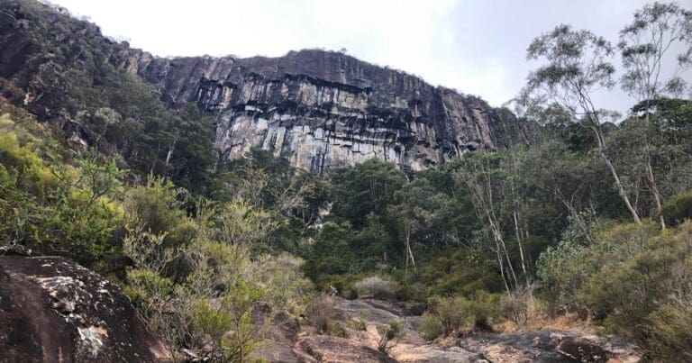
The initial section of the track treats you to a beautiful wet eucalypt forest. After roughly 1 kilometer, the scenery transitions into drier open forest. Here, the most demanding part of the hike begins. The remaining 700 meters consist of a very steep, paved pathway that can be slippery, particularly after rain. Sturdy shoes with good ankle support are crucial for safe navigation.
Persevere through the climb, and you'll be rewarded with breathtaking 360-degree views from the fire tower at the summit. On a clear day, you might even catch a glimpse of Brisbane's CBD! The fire tower plays a vital role in fire detection and management for the surrounding parks and forests.
Pace yourself throughout the climb, especially on the steeper sections. Take breaks as needed to admire the scenery and catch your breath. When descending the fire tower, remember to go down backwards for safety reasons, just like you would with a ladder. There are benches along the way to rest and enjoy the surrounding landscape.
The return trip follows the same route you took up the mountain. The car park at the trailhead offers convenient parking for your vehicle.
Indigenous Lore of the Glass House Mountains
The Glass House Mountains hold deep spiritual significance for the Aboriginal people of the region, particularly the Jinibara and Kabi Kabi peoples. Their lore and customs are intricately woven with the landscape, and these mountains hold a place of immense importance.
One such example is Mount Beerwah. Considered the ancestral mother by the Jinibara people, respect for motherhood is a cornerstone of their culture. As such, they teach the importance of protecting Mount Beerwah and view climbing it as disrespectful to this sacred site.
The surrounding peaks hold significance as well. Tibrogargan is seen as the father figure, with Ngungun, his loyal dingo, by his side. The mountains themselves represent their children. This interconnection highlights the deep respect the Indigenous people have for the land and its formations.
In line with this rich Indigenous tradition, visitors are asked to refrain from climbing the Glass House Mountains. This act of respect preserves the cultural significance of these sacred places for future generations.
Gallery
Got some great shots from this hike? Upload your photos here to inspire others and show off the beauty of the trail!
Click to view form >>
Submitting your photos doesn’t mean you lose ownership. You can be credited for your contributions, and you can request removal at any time.
Content use
Please don’t copy GPX files or content from this site to AllTrails or other platforms. Each trail has been personally mapped, documented, and refined to support Australia’s bushwalking and hiking community. While some details come from land managers, every listing reflects significant personal effort. This is a free, community-driven initiative—your respect helps keep it that way.
Walk map and GPX file
Max elevation: 260 m
Min elevation: 50 m
Total climbing: 242 m
Total descent: -242 m
Getting there
Getting to the trailhead: Glass House Mountains National Park.
Reaching the Mount Beerburrum Summit Walk trailhead is straightforward. By car, travel south on Steve Irwin Way and turn right onto Beerburrum Road in the township of Beerburrum. Keep an eye out for Parrot Park and Beerburrum State School on your left. Right after passing the school, look for a blue cemetery sign and turn right there. Park your car conveniently in the designated car park at the school. The trailhead for your adventure awaits at the back of the school car park.
Closest towns to this walk: Beerwah, Elimbah, Glass House Mountains, Landsborough, Maleny, Moodlu, Mooloolah Valley, Woodford
About the region
Explore the Glass House Mountains National Park: A Land of Dramatic Beauty and Rich History.
The Glass House Mountains National Park is a captivating landscape dominated by the craggy peaks that rise majestically from the surrounding plains. These volcanic plugs, formed millions of years ago, hold a significant place in Australian heritage and are listed on the Queensland and National Heritage Register.
Walking trails weave through open forests, leading you to lookouts boasting panoramic views of the mountains. Explore the base of Mount Tibrogargan for ever-changing perspectives, or conquer the summit of Mount Ngungun for breathtaking views of the surrounding peaks and landscapes.
For the adventurous, the Yul-yan-man track offers a challenging Grade 5 hike, perfect for experienced rock scramblers. Skilled climbers and abseilers will find other challenging routes and dedicated climbing areas to test their abilities.
Beyond the dramatic peaks, the park encompasses a scenic tapestry of pine plantations, bushland, and cultivated fields. Remnants of open eucalypt woodland and heath vegetation provide a habitat for diverse flora and fauna, including 20 plant species of high conservation value.
Lieutenant James Cook named these distinctive mountains during his voyage along Australia's east coast. Geologically, they are intrusive plugs formed by volcanic activity 26 to 27 million years ago.
The park holds deep cultural significance for the Aboriginal Traditional Owners. The Glass House Mountains served as a meeting place for ceremonies and trade, and many sacred sites are still protected within the park's boundaries.
Similar walks nearby
Looking for more walks in or near Glass House Mountains National Park? Try these trails with a similar difficulty grade.
Track grade
Grade 5 (Difficult) - Walks for the Most Experienced: Grade 5 represents the most challenging walking tracks on the AWTGS. These are only recommended for very experienced and fit walkers with specialised skills, including navigation and emergency first aid. Tracks are likely to be very rough, very steep, and unmarked. Walks may be more than 20 kilometers. These challenging walks demand a high level of fitness and experience to navigate difficult terrain, significant elevation changes, and potentially unformed paths.
Explore safe
Plan ahead and hike safely! Carry enough water, pack layers for changing conditions, and bring safety gear like a torch, PLB, and reliable communication device. Check official sources for trail updates, closures, and access requirements, and review local weather and bushfire advice. Most importantly, share your plans with someone before you go. Being prepared makes for a safer and more enjoyable hike! Stay Safe, Explore More, and Always #ExploreSafe.
Packing checklists
What you carry in your pack depends on factors like weather, terrain, and your adventure type. Not sure what to bring? My free planning, food, and packing checklists are a great starting point, covering day hikes, overnight trips, and multi-day adventures. Use them to customise your kit and always prioritise safety.
Let someone know
Before heading out, take a moment to fill out your trip intentions form. It’s a quick way to share your hike details with family or friends. If something goes wrong, they can notify emergency services, ensuring a faster response and peace of mind. Stay safe and enjoy your adventure
Suggest an edit
Spotted a change on this trail? Maybe there are new features, the route has shifted, or the trail is permanently closed. Whatever the update, I’d love your input. Your feedback helps fellow hikers stay informed and ensures that our trail info stays fresh and reliable.
Acknowledgement of Country
Trail Hiking Australia acknowledges the Traditional Owners of the lands on which we hike and pay respects to their Elders, past and present, and we acknowledge the First Nations people of other communities who may be here today.


4 Reviews on “Mount Beerburrum Summit Walk (3.5km)”
I dont know
What don’t you know?
This summit trek offered a challenging experience thanks to the unexpected downpour. The initial 1 kilometer through the bush was a breeze – a clear, flat trail with no difficulties. However, things changed dramatically when we reached the paved section. The incline here was incredibly steep. While pavement might seem preferable on an ascent, the angle made it surprisingly challenging.
Surprisingly, the ascent wasn’t the biggest hurdle. Even with worn-out shoes and limited grip, I managed to climb without much trouble. However, the descent in pouring rain was a different story. The combination of steepness and slippery pavement made it quite tricky, requiring a good level of hill fitness and caution for anyone with knee problems. This is definitely a hike for those seeking a challenge.