Hike at a Glance
Max elevation: 268m
Min elevation: 230m
Total Ascent: 41m
Hike overview
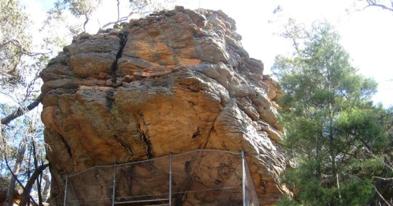
The Gulgurn Manja Shelter Walk is a 1.5 km return hike in Grampians National Park, Victoria, graded as an easy walk and typically completed in about 45 minutes. The walk begins at the Hollow Mountain Carpark, leading through scenic landscapes with views of surrounding rocky cliffs and ridges. The Gulgurn Manja Shelter, meaning "hands of young people," is a significant Aboriginal rock art site located at the northern tip of Gariwerd. This site holds cultural importance for the Jardwadjali people, who were able to observe fires from other groups on the plains to the north from this vantage point.
The shelter is known for its unique rock art, including bars, emu tracks, and numerous handprints, many of which were made by children. These handprints are a feature of the local art style in northern Gariwerd, used historically to tell stories and pass down the laws of the people. The fine-grained sandstone of the area was also used by the Jardwadjali to make stone tools, with visible marks in the shelter where stone was removed.
Gariwerd, the Aboriginal name for the Grampians, has deep cultural significance for the Djab Wurrung and Jardwadjali people, who have lived in the area for thousands of years. The Djab Wurrung primarily inhabited the plains to the east, while the Jardwadjali moved between the plains and the mountains depending on the season. The mountains were not only a source of food but also a place for fulfilling religious and kinship obligations.
The nearby plains, rich in swamps, lakes, and rivers, provided an abundant supply of food, including waterbirds, emus, possums, kangaroos, and fish. Local plants like yam-daisy, eucalypts, and wattles also offered essential resources. Fire was an important tool for the Aboriginal people, used to encourage new plant growth and increase food supplies, a practice that continues in some areas today.
Gulgurn Manja is one of over 100 Aboriginal rock art sites in Gariwerd, the richest area of Aboriginal rock art in Victoria. This site, along with four others, is promoted to visitors, offering a glimpse into the cultural heritage of the region. The story of fire, a significant part of Aboriginal mythology, is also connected to this landscape, teaching lessons about the use and control of fire that remain relevant today.
Gallery
Got some great shots from this hike? Upload your photos here to inspire others and show off the beauty of the trail!
Click to view form >>
Submitting your photos doesn’t mean you lose ownership. You can be credited for your contributions, and you can request removal at any time.
Content use
Please don’t copy GPX files or content from this site to AllTrails or other platforms. Each trail has been personally mapped, documented, and refined to support Australia’s bushwalking and hiking community. While some details come from land managers, every listing reflects significant personal effort. This is a free, community-driven initiative—your respect helps keep it that way.
Walk map and GPX file
Max elevation: 268 m
Min elevation: 230 m
Total climbing: 41 m
Total descent: -41 m
Getting there
Getting to the trailhead: Grampians National Park.
From Melbourne, follow the Western Highway through Stawell (235km) to Dadswells Bridge (and the big Koala). Continue on for 10.8km to turn left along Dadswell Bridge Road (signposted for Mount Zero). Follow the sealed road for 3km to turn left on unsealed Flat Rock Road. Drive for 3km to a t-intersection. Turn right on the Mount Zero-Halls Gap Road and follow it or 1.4km to turn left into Hollow Mountain Carpark.
Closest towns to this walk: Ararat, Cavendish, Dadswells Bridge, Dunkeld, Halls Gap, Horsham, Landsborough, Pomonal, Stawell, Warracknabeal, Wartook, Wartook Valley
About the region
Grampians National Park is part of the Gariwerd Aboriginal cultural landscape. Parks Victoria respects the deep and continuing connection that Traditional Owners have to these lands and waters, and we recognise their ongoing role in caring for Country.
Explore the natural beauty of the Grampians from its world-famous hiking trails. Discover majestic waterfalls, dazzling spring wildflower displays and awe-inspiring mountain panoramas. Cross paths with kangaroos, wallabies, emus and native birds. Heritage-listed for its Aboriginal heritage, animal and plant life, and stunning natural beauty, the Grampians National Park is one of Australia's most recognisable places. The best way to appreciate it is on one of its many world-class walks or hikes or by taking a scenic drive.
Traditionally known as Gariwerd, this region is home to the largest number of significant and ancient Aboriginal rock art paintings and shelters in southern Australia. A visit to Brambuk – The National Park & Cultural Centre will help you get the most of your trip to these rock shelters.
The Grampians draws walkers from around the world. Hike to the highest peak within the Grampians, Mount William, or explore the plethora of walks around Halls Gap and the Wonderland Range. Views from the Pinnacle are famous, but the steep walk should only be attempted by the fit. If you’re an experienced walker you’ll enjoy the unique challenge of the park’s overnight hikes. Choose from the iconic Grampians Peaks Trail, Major Mitchell Plateau or The Fortress and Mt Thackeray Overnight Hike.
There are more relaxing pursuits to enjoy in the Grampians, too. Go fishing, canoeing or kayaking at Lake Wartook, Lake Bellfield and Moora Moora Reservoir or one of the park’s many other streams and creeks.
Similar walks nearby
Looking for more walks in or near Grampians National Park? Try these trails with a similar difficulty grade.
Track grade
Grade 2 (Easy) - A Gentle Introduction to Inclines: Grade 2 on the AWTGS represents easy walking tracks that offer a slightly more challenging experience compared to Grade 1. Similar to Grade 1, no prior bushwalking experience is required. The track surface is typically hardened or compacted and may have gentle hill sections or occasional steps. The total distance of a Grade 2 walk is typically no greater than 10 kilometers. These walks are still suitable for families with a bit more experience or those seeking a gentle introduction to some inclines.
Explore safe
Plan ahead and hike safely! Carry enough water, pack layers for changing conditions, and bring safety gear like a torch, PLB, and reliable communication device. Check official sources for trail updates, closures, and access requirements, and review local weather and bushfire advice. Most importantly, share your plans with someone before you go. Being prepared makes for a safer and more enjoyable hike! Stay Safe, Explore More, and Always #ExploreSafe.
Packing checklists
What you carry in your pack depends on factors like weather, terrain, and your adventure type. Not sure what to bring? My free planning, food, and packing checklists are a great starting point, covering day hikes, overnight trips, and multi-day adventures. Use them to customise your kit and always prioritise safety.
Let someone know
Before heading out, take a moment to fill out your trip intentions form. It’s a quick way to share your hike details with family or friends. If something goes wrong, they can notify emergency services, ensuring a faster response and peace of mind. Stay safe and enjoy your adventure
Suggest an edit
Spotted a change on this trail? Maybe there are new features, the route has shifted, or the trail is permanently closed. Whatever the update, I’d love your input. Your feedback helps fellow hikers stay informed and ensures that our trail info stays fresh and reliable.
Acknowledgement of Country
Trail Hiking Australia acknowledges the Traditional Owners of the lands on which we hike and pay respects to their Elders, past and present, and we acknowledge the First Nations people of other communities who may be here today.


