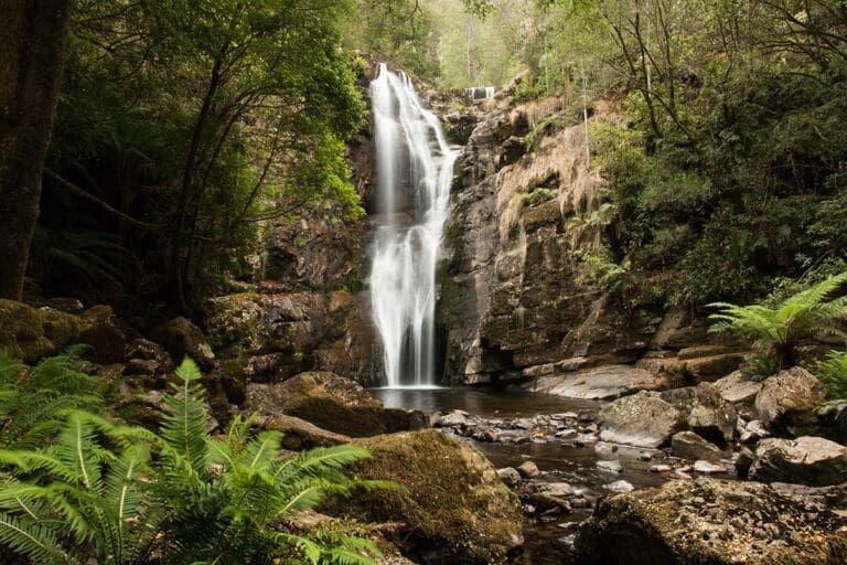
Hike at a Glance
Max elevation: 0m
Min elevation: 0m
Total Ascent: 0m
Hike overview
The magnificent white gums of Evercreech are amongst the tallest trees of their type in Australia. Interpretation signs tell visitors the story of these majestic trees. An excellent reserve for a family picnic gathering.
Tips
Toilets, picnic tables, picnic shelter, fireplaces and firewood.
Track to viewing platform may suit some wheelchair users and those with strollers.
Walking here is not recommended in strong winds or stormy weather trees and limbs may fall.
Dogs welcome on a leash. Camping, firearms or bicycles are not allowed.
For more information about this hiking trail please visit Parks and Wildlife Service Tasmania
Gallery
Got some great shots from this hike? Upload your photos here to inspire others and show off the beauty of the trail!
Click to view form >>
Submitting your photos doesn’t mean you lose ownership. You can be credited for your contributions, and you can request removal at any time.
Content use
Please don’t copy GPX files or content from this site to AllTrails or other platforms. Each trail has been personally mapped, documented, and refined to support Australia’s bushwalking and hiking community. While some details come from land managers, every listing reflects significant personal effort. This is a free, community-driven initiative—your respect helps keep it that way.
Walk map and GPX file
It looks like I don’t have a GPX file for this trail yet. If you have one to share, please email it to me! I’ll verify it against official maps before adding it to help other hikers have a safer, easier experience. Thanks for contributing to a better hiking resource.
Getting there
Getting to the trailhead: Evercreech Forest Reserve.
Road C423 from Ringarooma and follow signs to Evercreech Forest Reserve (unsealed roads).
Closest towns to this walk: Avoca, Campbell Town, Chudleigh, Deloraine, Fingal, Mole Creek, Railton, Ross, Sheffield, St Marys
About the region
Evercreech Forest Reserve is a beautiful natural reserve in Northern Tasmania. Nearby are the Mathinna Falls Forest Reserve and the Griffin Camping Area. These north-east forest reserves are attractive spots to break your journey on the A4 between the Midland Highway and the east coast. To reach them, turn left on the B43 at Fingal towards Mathinna. An interesting alternative route continues beyond Mathinna, taking gravel roads through the Mount Victoria Forest Reserve to reach the rich north-east farmlands at Ringarooma.
Similar walks nearby
Looking for more walks in or near Evercreech Forest Reserve? Try these trails with a similar difficulty grade.
Track grade
Grade 2 (Easy) - A Gentle Introduction to Inclines: Grade 2 on the AWTGS represents easy walking tracks that offer a slightly more challenging experience compared to Grade 1. Similar to Grade 1, no prior bushwalking experience is required. The track surface is typically hardened or compacted and may have gentle hill sections or occasional steps. The total distance of a Grade 2 walk is typically no greater than 10 kilometers. These walks are still suitable for families with a bit more experience or those seeking a gentle introduction to some inclines.
Explore safe
Plan ahead and hike safely! Carry enough water, pack layers for changing conditions, and bring safety gear like a torch, PLB, and reliable communication device. Check official sources for trail updates, closures, and access requirements, and review local weather and bushfire advice. Most importantly, share your plans with someone before you go. Being prepared makes for a safer and more enjoyable hike! Stay Safe, Explore More, and Always #ExploreSafe.
Packing checklists
What you carry in your pack depends on factors like weather, terrain, and your adventure type. Not sure what to bring? My free planning, food, and packing checklists are a great starting point, covering day hikes, overnight trips, and multi-day adventures. Use them to customise your kit and always prioritise safety.
Let someone know
Before heading out, take a moment to fill out your trip intentions form. It’s a quick way to share your hike details with family or friends. If something goes wrong, they can notify emergency services, ensuring a faster response and peace of mind. Stay safe and enjoy your adventure
Suggest an edit
Spotted a change on this trail? Maybe there are new features, the route has shifted, or the trail is permanently closed. Whatever the update, I’d love your input. Your feedback helps fellow hikers stay informed and ensures that our trail info stays fresh and reliable.
Acknowledgement of Country
Trail Hiking Australia acknowledges the Traditional Owners of the lands on which we hike and pay respects to their Elders, past and present, and we acknowledge the First Nations people of other communities who may be here today.


