Hike at a Glance
Max elevation: 797m
Min elevation: 278m
Total Ascent: 674m
Hike overview
Towering 880 meters over Hobart's western edge within Wellington Park, Cathedral Rock beckons adventurous hikers with its promise of stunning views. This challenging trek is not for the faint of heart, but the payoff is more than worth the effort.
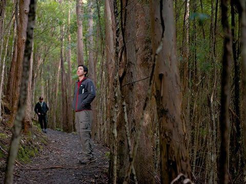
The journey begins with a pleasant stroll through lush, wet forest alongside the boulder-strewn North West Bay River. But soon, the gentle riverside walk transforms into a heart-pounding ascent. The official trail leads inland for a short stretch before rejoining the river and its dense cloak of giant ferns.
Here, the path merges with a steep fire trail that winds its way upwards for 3.5 kilometers. After conquering the switchbacks, you'll reach a saddle offering a brief respite before the real challenge begins.
The final ascent to Cathedral Rock's peak is a short but demanding scramble over rocky terrain. But the effort is quickly forgotten as you reach the summit and are greeted by an unparalleled panorama. From this vantage point, drink in the expansive view of southern Tasmania, encompassing the verdant Huon Valley and the D'Entrecasteaux Channel. Here, amidst the pristine wilderness, you'll truly understand the essence of Tasmania's natural splendor.
The descent follows the same path, rewarding you with a final lungful of cool, fresh air before returning you to the trailhead, a convenient 30-minute drive from Hobart CBD.
Tips
Be Prepared for Adventure:
- Sturdy hiking boots are essential for the final rocky climb, which can be slippery when wet.
- Pack layers and a raincoat. The weather can change quickly at higher elevations, and the summit is exposed.
- Bring plenty of water and snacks to keep your energy levels high.
- Always inform someone of your hiking plans and bring a basic first-aid kit just in case.
Know Before You Go:
- While rare, snakes have been spotted in Wellington Park. All Tasmanian snakes are venomous. Give them a wide berth and avoid provoking them. If bitten, seek immediate medical attention.
- The trail includes narrow sections, steep climbs, and loose riverbed pebbles. Be sure-footed and keep a close eye on children.
- Parking is limited at the trailhead, so plan to arrive early.
Gallery
Got some great shots from this hike? Upload your photos here to inspire others and show off the beauty of the trail!
Uploading your photos doesn’t mean you lose ownership. You can be credited for your contributions, and you can request removal at any time.
Content use
Please don’t copy GPX files or content from this site to AllTrails or other platforms. Each trail has been personally mapped, documented, and refined to support Australia’s bushwalking and hiking community. While some details come from land managers, every listing reflects significant personal effort. This is a free, community-driven initiative—your respect helps keep it that way.
Walk map and GPX file
Max elevation: 797 m
Min elevation: 278 m
Total climbing: 674 m
Total descent: -674 m
Getting there
Getting to the trailhead: Wellington Park.
The adventure to Cathedral Rock begins just outside Hobart! Head south on Davey Street (A6) for about 9 kilometers past the suburb of Fern Tree. Keep an eye out for Betts Road on your right.
Follow Betts Road for roughly 1 kilometer, crossing a stream along the way. You’ll find the carpark conveniently located at the end of the road. The entire drive from Hobart CBD is a breeze, taking only 30 minutes and covering approximately 23 kilometers.
Closest towns to this walk: Bellerive, Blackmans Bay, Bridgewater, Brighton, Claremont, Derwent Park, Fern Tree, Glenorchy, Hobart, Kingston, Mount Wellington, Sorell, South Hobart, Taroona
About the region
Wellington Park is an 18,011 reserve located on the doorstep of nipaluna / Hobart in southern lutruwita / Tasmania. The Park stretches west from the 1271m summit of kunanyi / Mount Wellington and includes spectacular lookouts, dramatic cliff faces, boulder fields, waterfalls, fern glades and amazing dolerite rock formations.
kunanyi / Mount Wellington is accessible to walkers via a network of recreational trails, shuttle bus from the Hobart waterfront or by car or bike on a sealed but winding road to the summit (the Pinnacle), noting that car parking in the Park is limited. The road may be closed due to ice and snow - check the Pinnacle Rd Status on the City of Hobart or Wellington Park Management Trust website before departing. Be prepared for extreme and changeable weather.
Lookouts and observation decks at the Pinnacle provide spectacular views over Hobart towards the east coast, to the west over the World Heritage Area of southern Tasmania, and to the south towards Bruny Island. Parking and toilet facilities are available.
The Park supports a network of tracks for walking, running, mountain bike riding, horse riding (permit required) and recreational 4WDs (permit required). Popular locations in the Park include The Springs picnic area and Lost Freight Cafe, Cathedral Rock, Myrtle Forest picnic area, the Octopus Tree, Sphinx Rock, the Organ Pipes and Glenorchy Mountain Bike Park.
Similar walks nearby
Looking for more walks in or near Wellington Park? Try these trails with a similar difficulty grade.
Track grade
Grade 4 (Hard) - Challenging Walks for Experienced Walkers: Grade 4 on the AWTGS signifies challenging walking tracks. Bushwalking experience is recommended for these tracks, which may be long, rough, and very steep. Directional signage may be limited, requiring a good sense of navigation. These walks are suited for experienced walkers who are comfortable with steeper inclines, rougher terrain, and potentially longer distances.
Explore safe
Plan ahead and hike safely! Carry enough water, pack layers for changing conditions, and bring safety gear like a torch, PLB, and reliable communication device. Check official sources for trail updates, closures, and access requirements, and review local weather and bushfire advice. Most importantly, share your plans with someone before you go. Being prepared makes for a safer and more enjoyable hike! Stay Safe, Explore More, and Always #ExploreSafe.
Packing checklists
What you carry in your pack depends on factors like weather, terrain, and your adventure type. Not sure what to bring? My free planning, food, and packing checklists are a great starting point, covering day hikes, overnight trips, and multi-day adventures. Use them to customise your kit and always prioritise safety.
Let someone know
Before heading out, take a moment to fill out your trip intentions form. It’s a quick way to share your hike details with family or friends. If something goes wrong, they can notify emergency services, ensuring a faster response and peace of mind. Stay safe and enjoy your adventure
Suggest an edit
Spotted a change on this trail? Maybe there are new features, the route has shifted, or the trail is permanently closed. Whatever the update, I’d love your input. Your feedback helps fellow hikers stay informed and ensures that our trail info stays fresh and reliable.
Acknowledgement of Country
Trail Hiking Australia acknowledges the Traditional Owners of the lands on which we hike and pay respects to their Elders, past and present, and we acknowledge the First Nations people of other communities who may be here today.


