Hike at a Glance
Max elevation: 95m
Min elevation: 12m
Total Ascent: 221m
Hike overview
The Cape Woolamai Walk provides breathtaking views of Phillip Island and its surrounding coastline. As the highest point on the island and home to the largest shearwater rookery, Cape Woolamai offers a unique and diverse hiking experience, particularly between October and April when thousands of shearwaters inhabit the area.
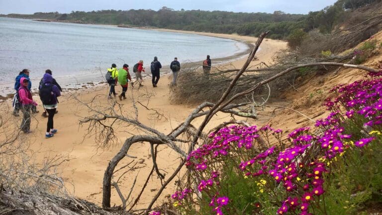
To embark on this adventure, start at the information shelter and descend the wooden ramp to the beach. Walk southeast along the expansive sandy strip towards a rocky point extending from Cape Woolamai. After covering 700 meters, spot a wooden staircase on the left before reaching the beach's end. Ascend the stairs to the grass-covered bluffs connecting Cape Woolamai's rocky end with the rest of Phillip Island.
At the top, a sign for Cape Woolamai Walking Trails directs you to turn right, while the service road to the left leads back to the parking area. The trail sign outlines three hiking options, each marked with a specific color used on trail markers. The described hike combines elements from all three routes:
1. Cape Woolamai Pinnacles Walk (Green Route): A 4.5-kilometer return trail leading 1.4 kilometers beyond the bluff to an overlook above the Pinnacles.
2. Cape Woolamai Beacon Walk (Black Route): A 7.5-kilometer route extending past the Pinnacles to the light beacon at Cape Woolamai's high point, circling back around the cape's end.
3. Old Granite Quarry Walk (Blue Route): A 5-kilometer trail crossing to the east side of the cape, reaching an old rock quarry. Return via the same route or complete the loop by walking back along the beach.
Follow the wide dirt trail south, enjoying views of Woolamai Beach to the right and muttonbird rookeries on the left. At 350 meters from the top of the steps, stay right at a junction, following black and green arrows towards the Pinnacles.
As you traverse the west coast of the cape, appreciate views of Woolamai Surf Beach to your right. After 550 meters, a short spur path on the right offers scenic views over the end of Woolamai Beach.
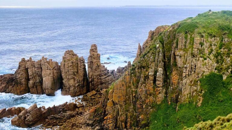
Below the bluff, encounter impressive rock formations, including the Pinnacles. Continue following black arrows for 2.05 kilometers to reach the summit at the tip of Cape Woolamai, where the Cape Woolamai Beacon sits at an elevation of 112 meters.
Proceed southeast to the cape's end, reaching a junction with a trail to the Old Granite Quarry. Follow the main trail for the 7.4-kilometer hike or turn right to explore the old quarry, eventually walking back along the east side of the cape.
After 4.25 kilometers, begin the return journey, heading inland along the cape's east coast. Descend a gradual slope to a wooden overlook with east-facing panoramic ocean views. Follow the loop trail, reaching a sign marking the old quarry area. Descend wooden stairs to the beach and, before heading to Cleeland Bight, explore granite slabs left when the quarry closed.
From the Old Granite Quarry, take a 1.7-kilometer stroll north up the beach. Upon encountering a tall trail post, turn left and follow the wide sandy track inland, following signs for Cape Woolamai Car Park.
Content use
Please don’t copy GPX files or content from this site to AllTrails or other platforms. Each trail has been personally mapped, documented, and refined to support Australia’s bushwalking and hiking community. While some details come from land managers, every listing reflects significant personal effort. This is a free, community-driven initiative—your respect helps keep it that way.
Walk map and GPX file
Max elevation: 95 m
Min elevation: 12 m
Total climbing: 221 m
Total descent: -221 m
Variation via Woodland Track
Max elevation: 112 m
Min elevation: -7 m
Total climbing: 441 m
Total descent: -439 m
Getting there
Getting to the trailhead: Cape Woolamai Faunal Reserve.
From Melbourne, take M1 east for approximately 30 kilometers to the exit for South Gippsland Freeway (M420) and drive south for 97 kilometers on M420 following signs for Phillip Island. Bear right onto Phillip Island Road (B420) to cross the bridge onto Phillip Island. Now continue another 3 kilometers to a intersection with Woolamai Beach Road and turn left. Drive 3 kilometers south to the car park at the end of the road.
Closest towns to this walk: Cape Woolamai, Cowes, Newhaven, Rhyll, San Remo, Sunderland Bay, Ventnor
About the region
Established in 1968, Cape Woolamai is a 308-hectare reserve protecting Phillip Island's southeastern tip, including its highest point – a 112-meter crest offering stunning panoramic views. While the summit itself isn't a challenging climb, the true beauty lies in the reserve's diverse landscape. Imagine vast stretches of sandy beaches contrasting with dramatic granite cliffs, creating a captivating scene for hikers of all levels.
Cape Woolamai boasts a network of trails catering to various preferences. Explore shorter options like the 1.6-kilometer route, perfect for a leisurely stroll, or challenge yourself with the 8.5-kilometer circuit encompassing the entire reserve.
Similar walks nearby
Looking for more walks in or near Cape Woolamai Faunal Reserve? Try these trails with a similar difficulty grade.
Track grade
Grade 3 (Moderate) - Walks for Most Fitness Levels: Grade 3 on the AWTGS represents moderate walking tracks. These are ideal for walkers with some fitness who are comfortable with some hills and uneven terrain. While suitable for most ages, some bushwalking experience is recommended to ensure a safe and enjoyable experience. Tracks may have short, steep hill sections, a rough surface, and many steps. The total distance of a Grade 3 walk can be up to 20 kilometers.
Explore safe
Plan ahead and hike safely! Carry enough water, pack layers for changing conditions, and bring safety gear like a torch, PLB, and reliable communication device. Check official sources for trail updates, closures, and access requirements, and review local weather and bushfire advice. Most importantly, share your plans with someone before you go. Being prepared makes for a safer and more enjoyable hike! Stay Safe, Explore More, and Always #ExploreSafe.
Packing checklists
What you carry in your pack depends on factors like weather, terrain, and your adventure type. Not sure what to bring? My free planning, food, and packing checklists are a great starting point, covering day hikes, overnight trips, and multi-day adventures. Use them to customise your kit and always prioritise safety.
Let someone know
Before heading out, take a moment to fill out your trip intentions form. It’s a quick way to share your hike details with family or friends. If something goes wrong, they can notify emergency services, ensuring a faster response and peace of mind. Stay safe and enjoy your adventure
Suggest an edit
Spotted a change on this trail? Maybe there are new features, the route has shifted, or the trail is permanently closed. Whatever the update, I’d love your input. Your feedback helps fellow hikers stay informed and ensures that our trail info stays fresh and reliable.
Acknowledgement of Country
Trail Hiking Australia acknowledges the Traditional Owners of the lands on which we hike and pay respects to their Elders, past and present, and we acknowledge the First Nations people of other communities who may be here today.
/Cape-Woolamai-Circuit-Walk_66.jpg)
/Cape-Woolamai-Circuit-Walk_106.jpg)
/Cape-Woolamai-Circuit-Walk_112.jpg)
/Cape-Woolamai-Circuit-Walk_4.jpg)
/Cape-Woolamai-Circuit-Walk_86.jpg)
/Cape-Woolamai-Circuit-Walk_21.jpg)
/Cape-Woolamai-Circuit-Walk_123.jpg)
/Cape-Woolamai-Circuit-Walk_16.jpg)
/Cape-Woolamai-Circuit-Walk_108.jpg)
/Cape-Woolamai-Circuit-Walk_94.jpg)
/Cape-Woolamai-Circuit-Walk_116.jpg)
/Cape-Woolamai-Circuit-Walk_97.jpg)
/Cape-Woolamai-Circuit-Walk_83.jpg)
/Cape-Woolamai-Circuit-Walk_82.jpg)
/Cape-Woolamai-Circuit-Walk_129.jpg)


10 Reviews on “Cape Woolamai Circuit Walk (8.5km)”
The Cape Woolamai Walk offers stunning coastal view and a chance to witness Phillip Island’s wildlife. As Phillip Island’s highest point, the walk provides panoramic views and a unique opportunity to see massive shearwater colonies between October and April. The well-marked trails cater to different preferences, ranging from a short stroll to a more challenging hike. After a short beach walk, you’ll reach the turnoff for the trails, allowing you to choose your adventure.
Great circuit with young kids but sad to see the extensive rabbit burrow damage. Our kids enjoyed rock pooling on the back beach. We did not see the colored arrows but the track is very well defined and there are track posts/emergency markers along the way.
Very pleasant walk. However note that in this section …
Once you have visited the Old Granite Quarry, you can take a 1.7-kilometer stroll north up the beach. Keep walking up the beach until you come to an area where the beach is backed by a steep slope of sand. Just past this sledding hill, there will be another tall trail post. Turn left here and head inland on a wide sandy track, following the sign for Cape Woolamai Car Park.
If the tide is high you will need to clamber along the steep dune to make your way around the trees and bushes.