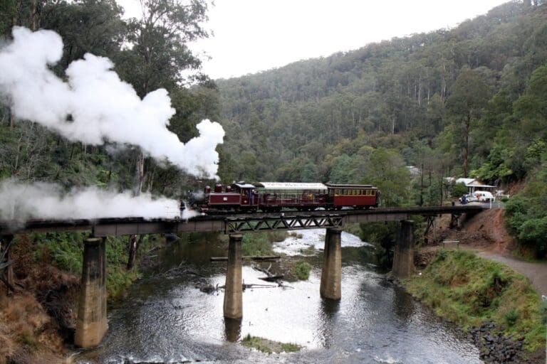
This trail is a favourite for enthusiasts who like mountain biking or walking in the bush. The trail passes through rainforest, fern gullies, messmate and stringybark forest, and there are plenty of birds, mammals and seasonal wildflowers. Expect fallen trees across the trail and watch out for snakes in summer.
From Tyers Junction, explore the walking tracks along the eastern and western branches of the tramway.
The most interesting walk is along the Eastern Tyers River. These trails are less developed and are suitable for walking only. Ask at the Caringal Scout camp at Tyers Junction for further directions.
The Walhalla Goldfields Rail Trail is nearby.Petersons Lookout in Tyers Park has views of the Tyers Gorge and Latrobe Valley from a viewing platform and also picnic facilities.
For more information on this trail see the book Rail Trails of Victoria and South Australia.
The Tyers Valley Tramway was a narrow gauge timber tramway built by the Forestry Commission of Victoria to exploit timber resources on the slopes of Mount Baw Baw, Victoria. The tramway met with the Victorian Railways narrow gauge line from Moe to Walhalla at Collins Siding, and was built to the same 2 ft 6 in (762 mm) gauge. The tramways serving the Tyers Valley were largely destroyed by bushfires in 1926. Rather than rebuild the private tramways, the Forestry Commission, a government body, decided to construct a higher quality tramway to serve all the private sawmills in the district.
Collins Siding to Tyers Junction in Gippsland
Gippsland, 30km north of Moe, 160km from Melbourne
Compacted earth
Hilly
Photo credit: Rail Trails Australia. For more information and a location map please visit RailTrails Australia.
Got some great shots from this hike? Upload your photos here to inspire others and show off the beauty of the trail!
Submitting your photos doesn’t mean you lose ownership. You can be credited for your contributions, and you can request removal at any time.
Please don’t copy GPX files or content from this site to AllTrails or other platforms. Each trail has been personally mapped, documented, and refined to support Australia’s bushwalking and hiking community. While some details come from land managers, every listing reflects significant personal effort. This is a free, community-driven initiative—your respect helps keep it that way.
It looks like I don’t have a GPX file for this trail yet. If you have one to share, please email it to me! I’ll verify it against official maps before adding it to help other hikers have a safer, easier experience. Thanks for contributing to a better hiking resource.
Getting there
Getting to the trailhead: Gippsland.
Closest towns to this walk: Drouin, Jindivick, Mirboo North, Moe, Morwell, Neerim South, Rokeby, Traralgon, Warragul
About the region
Stretch your legs in some of Victoria's most spectacular national parks, be charmed by tiny towns, and indulge in gourmet fresh produce in Gippsland. Amble along Ninety Mile Beach, set up camp in Wilsons Prom or set sail on the Gippsland Lakes. Feed your curiosity at galleries and studios, or at local cellar doors, boutique distilleries and renowned restaurants.
Similar walks nearby
Looking for more walks in or near Gippsland? Try these trails with a similar difficulty grade.
Favourite

Favourite

Favourite

Favourite

Track grade
Grade 3 (Moderate) - Walks for Most Fitness Levels: Grade 3 on the
AWTGS represents moderate walking tracks. These are ideal for walkers with some fitness who are comfortable with some hills and uneven terrain. While suitable for most ages, some bushwalking experience is recommended to ensure a safe and enjoyable experience. Tracks may have short, steep hill sections, a rough surface, and many steps. The total distance of a Grade 3 walk can be up to 20 kilometers.
Explore safe
Plan ahead and hike safely! Carry enough water, pack layers for changing conditions, and bring safety gear like a torch, PLB, and reliable communication device. Check official sources for trail updates, closures, and access requirements, and review local weather and bushfire advice. Most importantly, share your plans with someone before you go. Being prepared makes for a safer and more enjoyable hike! Stay Safe, Explore More, and Always #ExploreSafe.
Packing checklists
What you carry in your pack depends on factors like weather, terrain, and your adventure type. Not sure what to bring? My free planning, food, and packing checklists are a great starting point, covering day hikes, overnight trips, and multi-day adventures. Use them to customise your kit and always prioritise safety.
Let someone know
Before heading out, take a moment to fill out your trip intentions form. It’s a quick way to share your hike details with family or friends. If something goes wrong, they can notify emergency services, ensuring a faster response and peace of mind. Stay safe and enjoy your adventure
Suggest an edit
Spotted a change on this trail? Maybe there are new features, the route has shifted, or the trail is permanently closed. Whatever the update, I’d love your input. Your feedback helps fellow hikers stay informed and ensures that our trail info stays fresh and reliable.


