Hike at a Glance
Max elevation: 1134m
Min elevation: 542m
Total Ascent: 891m
Important info
The peak of St. Mary Peak holds deep cultural significance for the Adnyamathanha people, featuring prominently in their creation story. In respect of their traditions, the Adnyamathanha request that visitors refrain from climbing to the absolute summit.
Hike overview
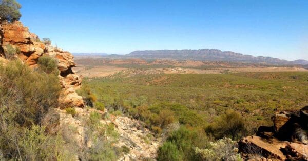
Encompassing breathtaking 360-degree views of the Flinders Ranges, salt lakes, and surrounding plains, St. Mary Peak stands as the highest point in South Australia and the crown jewel of a challenging scenic hike. This circular route leads you to the summit of St. Mary Peak, reaching an elevation of 1,171 meters. Panoramic views reward your efforts, showcasing the Flinders Ranges themselves, Aroona Valley, and the vast salt plains stretching westward.
Planning is essential for this trek. Consider a two-day adventure with camping at Cooinda Camp nestled within Wilpena Pound. Be aware that this campsite lacks amenities like water and toilets. Alternatively, water is available at Hills Homestead, situated close to the starting point at the Wilpena Pound trailhead. Park rangers recommend commencing the hike no later than 9am (or 10am during daylight saving time).
It's important to acknowledge the cultural significance of St. Mary Peak for the Adnyamathanha people, who consider it central to their creation story. As a gesture of respect, they request that visitors refrain from reaching the absolute summit. A shorter option to Tanderra Saddle provides equally stunning views and remains a fantastically challenging walk accessible to those with moderate fitness and a sense of adventure.
Track grade
Grade 4 (Hard) - Challenging Walks for Experienced Walkers: Grade 4 on the AWTGS signifies challenging walking tracks. Bushwalking experience is recommended for these tracks, which may be long, rough, and very steep. Directional signage may be limited, requiring a good sense of navigation. These walks are suited for experienced walkers who are comfortable with steeper inclines, rougher terrain, and potentially longer distances.
Walk map and GPX file
Max elevation: 1134 m
Min elevation: 542 m
Total climbing: 891 m
Total descent: -891 m
Content use
Please don’t copy GPX files or content from this site to AllTrails or other platforms. Each trail has been personally mapped, documented, and refined to support Australia’s bushwalking and hiking community. While some details come from land managers, every listing reflects significant personal effort. This is a free, community-driven initiative—your respect helps keep it that way.
Getting there
Getting to the trailhead: Ikara-Flinders Ranges National Park.
Ikara-Flinders Ranges National Park is located approximately 450 kilometres north of Adelaide in the central Flinders Ranges. To reach the park from Adelaide, take one of several routes to Hawker, then follow the signs to Wilpena. If traveling from Leigh Creek in the north, head south to Parachilna and enter the park from either the north or the west. Alternatively, you can head east from Leigh Creek towards Vulkathunha-Gammon Ranges National Park, then follow the signs south to Ikara-Flinders Ranges National Park. From Broken Hill, turn north at Yunta on the Arkaroola Road and follow the signs to Blinman.
The main road through the park and into Wilpena Pound is sealed, but unsealed roads with changing surfaces are common throughout the park and may be affected by weather conditions. All public roads are accessible by two-wheel drive vehicles, caravans, and trailers. Please drive slowly and respect other road users.
Need a rental car to get you to the hike? Find one here.
Find a place to stay
Wondering where to stay near this hike? Find accommodation close to the trailhead — hotels, cabins and campgrounds nearby. Click the button to view the interactive map.
Closest towns to this walk: Beltana, Blinman, Copley, Cradock, Hawker, Leigh Creek, Parachilna, Quorn, Wilpena Pound
Let someone know
Heading out? Fill in a trip intentions form so someone knows your plans. If things go wrong, they can raise the alarm fast, giving you peace of mind on the trail.
About the region
Ancient and rugged mountain landscapes, peaceful tree-lined gorges, and a seasonal wealth of wildlife combine to make Ikara-Flinders Ranges National Park one of South Australia's iconic destinations. Covering approximately 95,000 hectares, the park includes the Heysen Range, Brachina and Bunyeroo Gorges, and the vast amphitheatre of mountains known as Wilpena Pound. Visitors can experience native wildlife, rich cultural heritage, impressive geological features, and a range of activities including bushwalking, four-wheel driving, birdwatching, photography, and mountain biking. Mild temperatures from April to October make this period the most comfortable for bushwalking and cycling, while summer temperatures can range from 30ºC to 45ºC.
Ikara-Flinders Ranges National Park has a rich and complex cultural heritage, combining Aboriginal and pastoral history. The park is co-managed by a board consisting of Adnyamathanha and Department for Environment and Water representatives. The Adnyamathanha people, meaning "hills or rock people," are the traditional custodians of the park, with a connection to the land that stretches back thousands of years. Visitors can view ancient rock paintings and engravings at Arkaroo Rock, Sacred Canyon, and Perawurtina Cultural Heritage Site.
Rugged mountain ranges, dramatic gorges, peaceful creeks lined with river red gums, and abundant wildlife are just the beginning of what awaits at one of South Australia's most popular tourist destinations.
Similar walks nearby
Looking for more walks in or near Ikara-Flinders Ranges National Park? Try these trails with a similar difficulty grade.
Explore safe
Plan ahead and hike safely! Carry enough water, pack layers for changing conditions, and bring safety gear like a torch, PLB, and reliable communication device. Check official sources for trail updates, closures, and access requirements, and review local weather and bushfire advice. Most importantly, share your plans with someone before you go. Being prepared makes for a safer and more enjoyable hike! Stay Safe, Explore More, and Always #ExploreSafe.
Packing checklists
What you carry in your pack depends on factors like weather, terrain, and your adventure type. Not sure what to bring? My free planning, food, and packing checklists are a great starting point, covering day hikes, overnight trips, and multi-day adventures. Use them to customise your kit and always prioritise safety.
Suggest an edit
Notice something different about this trail? Whether it’s a new feature, a route change, or a closure, share your update so we can keep our info accurate and helpful for fellow hikers.
Click to suggest edits >>
Acknowledgement of Country
Trail Hiking Australia acknowledges the Traditional Owners of the lands on which we hike and pay respects to their Elders, past and present, and we acknowledge the First Nations people of other communities who may be here today.
/St-Mary-Peak-Circuit-Hike-Wilpena-Pound_30.jpg)
/St-Mary-Peak-Circuit-Hike-Wilpena-Pound_1.jpg)
/St-Mary-Peak-Circuit-Hike-Wilpena-Pound_3.jpg)
/St-Mary-Peak-Circuit-Hike-Wilpena-Pound_38.jpg)
/St-Mary-Peak-Circuit-Hike-Wilpena-Pound_40.jpg)
/St-Mary-Peak-Circuit-Hike-Wilpena-Pound_31.jpg)
/St-Mary-Peak-Circuit-Hike-Wilpena-Pound_17.jpg)
/St-Mary-Peak-Circuit-Hike-Wilpena-Pound_46.jpg)
/St-Mary-Peak-Circuit-Hike-Wilpena-Pound_37.jpg)
/St-Mary-Peak-Circuit-Hike-Wilpena-Pound_41.jpg)
/St-Mary-Peak-Circuit-Hike-Wilpena-Pound_33.jpg)
/St-Mary-Peak-Circuit-Hike-Wilpena-Pound_36.jpg)
/St-Mary-Peak-Circuit-Hike-Wilpena-Pound_5.jpg)
/St-Mary-Peak-Circuit-Hike-Wilpena-Pound_15.jpg)
/St-Mary-Peak-Circuit-Hike-Wilpena-Pound_8.jpg)


9 Reviews on “St Mary Peak Circuit Hike - Wilpena Pound (21km)”
Paddy Dower keen???
The notes say there is no water at the campsite and that’s correct but you can generally get water from some rock holes upstream – even in a bad year. We did the walk again late last year and found plenty of water. I’m happy to send the GPS coordinates of the rock hole if anyone wants them.
Luke Fisher
Anne Macrae Helen Panayi
Zita Garner here’s one. ?. I love the Flinders ranges.