Hike at a Glance
Max elevation: 837m
Min elevation: 383m
Total Ascent: 717m
Hike overview
The Historic Nightcap walking track weaves through lush, World Heritage-listed rainforest in the Whian Whian State Conservation Area on the North Coast of New South Wales. Spanning 18 kilometres, the track typically takes one to two days to complete and is best suited to hikers with a good level of fitness and experience. While the trail can be tackled in either direction, heading west to east is often considered the more forgiving option, particularly for those planning to camp overnight at Rummery Park campground.
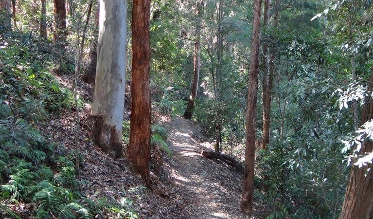
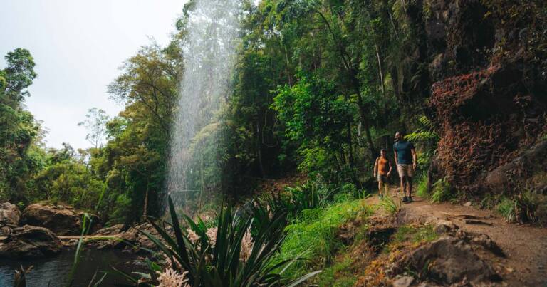
This walk offers a deep sense of immersion in the surrounding landscape. Towering trees, thick with epiphytes and mosses, form a dense green canopy overhead, while the path beneath your feet is softened by leaf litter and occasionally broken by tangled roots or weathered stone. Along the way, the rainforest opens at times to reveal sweeping escarpment views across Nightcap National Park and beyond—a gentle reminder of the vast, untamed country that stretches far past the track itself.
The route holds more than just natural beauty. In the 1800s and early 1900s, it served as a vital link between the towns of Lismore and Murwillumbah. Travellers and postal workers moved through these rugged hills on foot and horseback, tracing the same ridgelines and creek beds you’ll follow today. Echoes of that past can still be felt in the remoteness of the terrain and the quiet rhythm of the forest.
As you walk, keep an eye out for the smaller wonders of the trail. Rock orchids bloom along shaded ledges, offering a splash of colour against the greenery. If you move quietly, you might catch a glimpse of a long-nosed potoroo darting through the undergrowth, or spot a brush turkey scratching through the leaf litter. Birdsong is a constant companion, and with luck, you may hear or even see the elusive Albert’s lyrebird—a master mimic and one of the region’s most captivating residents.
The Historic Nightcap walking track is a rewarding journey through a landscape shaped by time, weather, and the footsteps of those who came before. Whether you're drawn by the solitude, the history, or the rich biodiversity, this trail offers an experience that lingers long after the walk is over.
Tips
- Contact the local NPWS office before planning an overnight or extended walk to get up-to-date information on track conditions, weather, and possible closures.
- Check the weather forecast before heading out, as the road to Historic Nightcap walking track can become boggy after rain.
- Bring a topographic map and compass, or a GPS, to navigate the trail with confidence.
- Prepare for the area's extreme and unpredictable weather by packing suitable gear and clothing.
- Since the track is in a remote location, ensure you have appropriate clothing, equipment, and let a friend or family member know your travel plans.
- This walk is best suited for experienced bushwalkers who are comfortable with self-reliant hiking.
- For safety, groups of 3-5 people are recommended, with at least one experienced bushwalker.
- A Personal Locator Beacon (PLB) is recommended, but should only be used in a life-threatening emergency.
- Camping is available at Rummery Park for those wishing to extend their hike overnight.
- Pack sunscreen and a hat to protect yourself from the sun.
- Consider bringing a gas or fuel stove, especially during the summer months and fire season.
Gallery
Got some great shots from this hike? Upload your photos here to inspire others and show off the beauty of the trail!
Click to view form >>
Submitting your photos doesn’t mean you lose ownership. You can be credited for your contributions, and you can request removal at any time.
Content use
Please don’t copy GPX files or content from this site to AllTrails or other platforms. Each trail has been personally mapped, documented, and refined to support Australia’s bushwalking and hiking community. While some details come from land managers, every listing reflects significant personal effort. This is a free, community-driven initiative—your respect helps keep it that way.
Walk map and GPX file
Max elevation: 837 m
Min elevation: 383 m
Total climbing: 717 m
Total descent: -1117 m
Getting there
Getting to the trailhead: Whian Whian State Conservation Area.
Getting to the Historic Nightcap walking track is straightforward, but the approach varies depending on where you’re coming from. If you’re starting from Nimbin, head down Sibley Street, passing the Nimbin Bowling Club, then turn right onto Gungas Street. After 1.5 kilometres, turn right again onto Tuntable Falls Road, following the signs for ‘Mount Nardi.’ Continue for another 4.2 kilometres, passing the Upper Tuntable Falls Road intersection, where the road becomes Newton Drive. Travel a further 4.8 kilometres to the park entrance, and then another kilometre to reach the Mount Nardi carpark.
From the eastern park entrance near Rosebank, follow Minyon Drive past the Minyon Falls picnic area, cross the causeway, and keep going until you reach the Peates Mountain Road intersection. Turn right onto Peates Mountain Road, and you’ll find the track about 100 metres to the north, roughly 4 kilometres from the intersection. If you’re coming from the southern park entrance on Nightcap Range Road via Dunoon, head north to the top of the range, then turn left onto Peates Mountain Road. The track will be approximately 100 metres north, around 5 kilometres from the turn-off. Parking is available at the Mount Nardi carpark, which is conveniently located near the trailhead.
Closest towns to this walk: Bangalow, Clunes, Dunoon, Federal, Kyogle, Lismore, Mullumbimby, Nimbin
About the region
Located just 30 kilometres north of Lismore in northern New South Wales—around 730 kilometres from Sydney—Whian Whian State Conservation Area is a rewarding destination for walks, bushwalks, and hikes. Bordering Nightcap National Park, it offers a variety of all trails through ancient rainforests, creeks, and ridgelines, with options for walking, mountain biking, and horse riding.
Trails wind through towering kauri, bunya and hoop pines, offering chances to spot native wildlife like goannas, kookaburras, and brushtail possums. The area also supports threatened species including the spotted-tailed quoll, koalas, and Albert’s lyrebird, whose calls often echo through the forest during cooler months.
For longer adventures, Rummery Park campground is a great base. Once a forestry camp, it now welcomes overnight bushwalkers tackling routes like the Historic Nightcap Track from Mount Nardi, 18 kilometres to the west. Day walkers will find plenty of trails suitable for a quick forest escape or longer hikes with scenic stops for swimming or a picnic.
Each season offers something special. In autumn and winter, the cooler weather suits longer bushwalks. Spring brings wildflowers and the Freedom Marathon. Summer is best spent swimming in Boggy Creek’s clear pools. With over 520 plant species and 10 broad ecosystems, the biodiversity here is striking.
This is also a place of deep cultural significance. The Widjabal people of the Bundjalung Nation have lived in and cared for this land for at least 4,000 years. Timber-getters arrived in the 1830s, and many of today’s walking tracks follow routes originally cleared for the red cedar trade.
Similar walks nearby
Looking for more walks in or near Whian Whian State Conservation Area? Try these trails with a similar difficulty grade.
Track grade
Grade 4 (Hard) - Challenging Walks for Experienced Walkers: Grade 4 on the AWTGS signifies challenging walking tracks. Bushwalking experience is recommended for these tracks, which may be long, rough, and very steep. Directional signage may be limited, requiring a good sense of navigation. These walks are suited for experienced walkers who are comfortable with steeper inclines, rougher terrain, and potentially longer distances.
Explore safe
Plan ahead and hike safely! Carry enough water, pack layers for changing conditions, and bring safety gear like a torch, PLB, and reliable communication device. Check official sources for trail updates, closures, and access requirements, and review local weather and bushfire advice. Most importantly, share your plans with someone before you go. Being prepared makes for a safer and more enjoyable hike! Stay Safe, Explore More, and Always #ExploreSafe.
Packing checklists
What you carry in your pack depends on factors like weather, terrain, and your adventure type. Not sure what to bring? My free planning, food, and packing checklists are a great starting point, covering day hikes, overnight trips, and multi-day adventures. Use them to customise your kit and always prioritise safety.
Let someone know
Before heading out, take a moment to fill out your trip intentions form. It’s a quick way to share your hike details with family or friends. If something goes wrong, they can notify emergency services, ensuring a faster response and peace of mind. Stay safe and enjoy your adventure
Suggest an edit
Spotted a change on this trail? Maybe there are new features, the route has shifted, or the trail is permanently closed. Whatever the update, I’d love your input. Your feedback helps fellow hikers stay informed and ensures that our trail info stays fresh and reliable.
Acknowledgement of Country
Trail Hiking Australia acknowledges the Traditional Owners of the lands on which we hike and pay respects to their Elders, past and present, and we acknowledge the First Nations people of other communities who may be here today.


9 Reviews on “Historic Nightcap Walking Track (18km)”
The road from rummery Park to peats Mt is closed to traffic so allow time to walk that section too