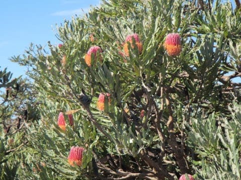
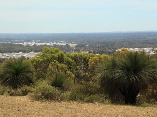
A short and easy walk in the Beeliar Regional Park to a vantage point giving 360 degree views to Cockburn Sound, and inland surrounding areas.
The Beeliar Regional Park consists of two chains of wetlands comprised of 26 lakes and numerous wetlands stretching 25 kimlometres along the coast and covering an area of approximately 3400 hectares. Mount Brown lies in the western chain close to the Indian Ocean. The wetlands were important camping, ceremonial areas and sources of food for Aboriginal people. The vegetation communities found in the park represent communities once widespread on the Swan Coastal Plain but now significantly decreased. The walk up Mount Brown is only 1 kilometre each way and there is a connecting path to the Lake Mount Brown walk trail from near the top of the hill.
Start Point: Cockburn Road, Henderson, 40km (30 minute drive) south of Perth
End Point: Cockburn Road, Henderson, 40km (30 minute drive) south of Perth
Region: Beeliar Regional Park, Perth
For more information, a location map and GPS file please visit Trails WA.
Got some great shots from this hike? Upload your photos here to inspire others and show off the beauty of the trail!
Submitting your photos doesn’t mean you lose ownership. You can be credited for your contributions, and you can request removal at any time.
Please don’t copy GPX files or content from this site to AllTrails or other platforms. Each trail has been personally mapped, documented, and refined to support Australia’s bushwalking and hiking community. While some details come from land managers, every listing reflects significant personal effort. This is a free, community-driven initiative—your respect helps keep it that way.
It looks like I don’t have a GPX file for this trail yet. If you have one to share, please email it to me! I’ll verify it against official maps before adding it to help other hikers have a safer, easier experience. Thanks for contributing to a better hiking resource.
Getting there
Getting to the trailhead: Beeliar Regional Park.
Closest towns to this walk: Atwell, Beeliar, Cockburn Central, Hamilton Hill, Jandakot, Success, Yangebup
About the region
Beeliar Regional Park is a range of coastal wetlands containing an array of nature appreciation possibilities within the suburban confines of Perth.
Similar walks nearby
Looking for more walks in or near Beeliar Regional Park? Try these trails with a similar difficulty grade.
Favourite

Favourite

Favourite

Favourite

Kings Park and Botanic Garden
Track grade
Grade 2 (Easy) - A Gentle Introduction to Inclines: Grade 2 on the
AWTGS represents easy walking tracks that offer a slightly more challenging experience compared to Grade 1. Similar to Grade 1, no prior bushwalking experience is required. The track surface is typically hardened or compacted and may have gentle hill sections or occasional steps. The total distance of a Grade 2 walk is typically no greater than 10 kilometers. These walks are still suitable for families with a bit more experience or those seeking a gentle introduction to some inclines.
Explore safe
Plan ahead and hike safely! Carry enough water, pack layers for changing conditions, and bring safety gear like a torch, PLB, and reliable communication device. Check official sources for trail updates, closures, and access requirements, and review local weather and bushfire advice. Most importantly, share your plans with someone before you go. Being prepared makes for a safer and more enjoyable hike! Stay Safe, Explore More, and Always #ExploreSafe.
Packing checklists
What you carry in your pack depends on factors like weather, terrain, and your adventure type. Not sure what to bring? My free planning, food, and packing checklists are a great starting point, covering day hikes, overnight trips, and multi-day adventures. Use them to customise your kit and always prioritise safety.
Let someone know
Before heading out, take a moment to fill out your trip intentions form. It’s a quick way to share your hike details with family or friends. If something goes wrong, they can notify emergency services, ensuring a faster response and peace of mind. Stay safe and enjoy your adventure
Suggest an edit
Spotted a change on this trail? Maybe there are new features, the route has shifted, or the trail is permanently closed. Whatever the update, I’d love your input. Your feedback helps fellow hikers stay informed and ensures that our trail info stays fresh and reliable.


