Hike at a Glance
Max elevation: 291m
Min elevation: 8m
Total Ascent: 953m
Hike overview
The Great Otway National Park is a spectacular area of native forest, and there are plenty of opportunities to get closer to nature with walking tracks and trails in the area, many leading to spectacular crashing waterfalls.
There are seven waterfalls within the bushland surrounding Lorne, with different accessibility levels - some are a quick ten minute stroll from the carpark, others are a more strenuous rainforest hike rewarded with the majestic roar of a waterfall.
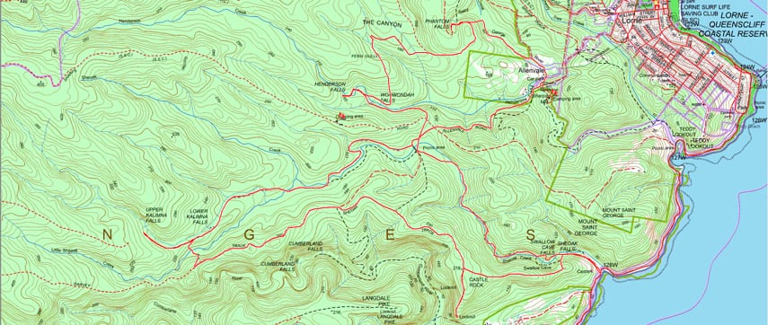
The Lorne Waterfalls - Canyon and Castle Rock hike starts and ends at the Sheoak Falls Carpark and can be undertaken in a clockwise or anti-clockwise direction. This hike takes in a number of The Otway's most spectacular waterfalls.
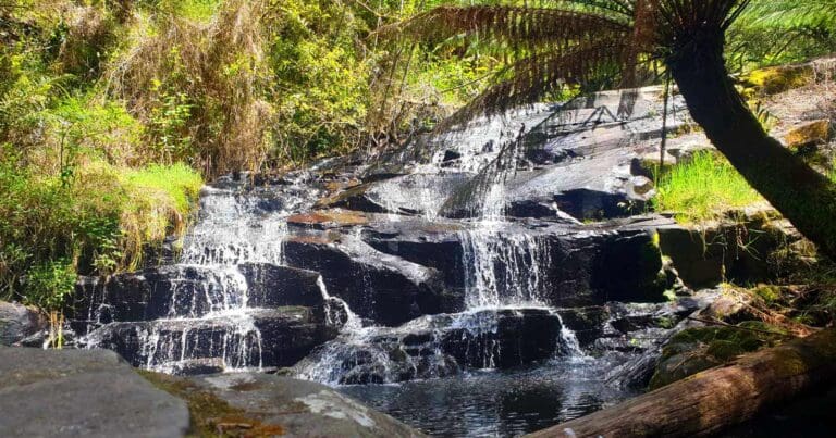
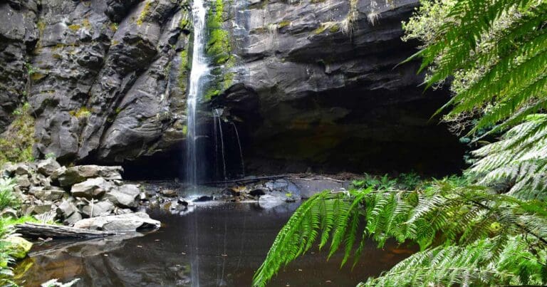
Kalimna falls (8 to 10 meters high) are fringed by tall rainforest trees and dense tree ferns. The Lower Falls are not large, but you can get behind them and look out through the falling water to the large pool surrounded by mossy logs and rocks. The Upper Falls are a series of cascades viewed from a platform. The walk follows the route of an old tramway and some of the old sleepers can still be seen.
Wonwondha Falls, Henderson Falls, the Canyon and the stunning Phantom Falls (about 15 meters high) are all en-route to the Sheoak Creek Picnic area, along Allenvale Rd. There are barbecue facilities, toilets, picnic tables, fireplaces and drinking water.
Camping
If you decide to do this as an overnight hike there are two options for Camping along the trail. See details and map below. Flags mark the camp site locations
- Sharps Track Camping Area. Located on the north west of the trail near Wonwondah Falls. Approximately 100 west along Sharps Road. This campsite is approximately 13km from the start so makes a good half way point.
- Allenvale Camp Site. Located on the north east of the trail near Sharps Mill, just off Allenvale Road. Approximately 18km from the start.
Content use
Please don’t copy GPX files or content from this site to AllTrails or other platforms. Each trail has been personally mapped, documented, and refined to support Australia’s bushwalking and hiking community. While some details come from land managers, every listing reflects significant personal effort. This is a free, community-driven initiative—your respect helps keep it that way.
Walk map and GPX file
Max elevation: 291 m
Min elevation: 8 m
Total climbing: 953 m
Total descent: -953 m
Getting there
Getting to the trailhead: Great Otway National Park.
From Melbourne by car
Follow the Princes Highway (M1) from Melbourne to Geelong, then take the Great Ocean Road (B100) through Torquay to Lorne. Or follow the Princes Highway (M1) from Melbourne to Geelong to Winchelsea (A1). Then take C151 via Deans Marsh to Lorne. The Sheoak Falls carpark is located 5.7km past the Lorne Visitors Information Centre, along the Great Ocean Road.
Public Transport to Lorne
V-line train/coach services depart daily from Melbourne to Geelong and along the Great Ocean Road to Lorne and Apollo Bay. V-line coach services connect along the Great Ocean Road from Apollo Bay to Port Campbell and Warrnambool on Friday all year (extra service during December -January). V-line enquiries – phone 136196. The Sheoak Falls carpark is located 5.7km past the Lorne Visitors Information Centre, along the Great Ocean Road.
Closest towns to this walk: Apollo Bay, Beech Forest, Colac, Forrest, Lavers Hill, Lorne, Skenes Creek, Wye River
About the region
Great Otway National Park stretches from Torquay, along the world-famous Great Ocean Road and up through the Otways hinterland. Discover windswept coastlines and breathtaking waterfalls in tall mountain forests, walk the iconic Great Ocean Walk, immerse yourself in the Otway Lightstation's history, or surf some of the best breaks in Australia. Enjoy the great outdoors and explore the wonders of the Great Otway National Park. Great Otway National Park is in southern Victoria, Australia. It covers rugged coastland, beaches and the mountains of the Otway Ranges. Waterfalls dot the park, including the 3 cascades of Triplet Falls. Boardwalks lead through temperate rainforest at Maits Rest. The 1848 Cape Otway Lightstation perches on cliffs overlooking Bass Strait. Great Ocean Walk leads through the park to the Twelve Apostles rock formations.
Similar walks nearby
Looking for more walks in or near Great Otway National Park? Try these trails with a similar difficulty grade.
Track grade
Grade 4 (Hard) - Challenging Walks for Experienced Walkers: Grade 4 on the AWTGS signifies challenging walking tracks. Bushwalking experience is recommended for these tracks, which may be long, rough, and very steep. Directional signage may be limited, requiring a good sense of navigation. These walks are suited for experienced walkers who are comfortable with steeper inclines, rougher terrain, and potentially longer distances.
Explore safe
Plan ahead and hike safely! Carry enough water, pack layers for changing conditions, and bring safety gear like a torch, PLB, and reliable communication device. Check official sources for trail updates, closures, and access requirements, and review local weather and bushfire advice. Most importantly, share your plans with someone before you go. Being prepared makes for a safer and more enjoyable hike! Stay Safe, Explore More, and Always #ExploreSafe.
Packing checklists
What you carry in your pack depends on factors like weather, terrain, and your adventure type. Not sure what to bring? My free planning, food, and packing checklists are a great starting point, covering day hikes, overnight trips, and multi-day adventures. Use them to customise your kit and always prioritise safety.
Let someone know
Before heading out, take a moment to fill out your trip intentions form. It’s a quick way to share your hike details with family or friends. If something goes wrong, they can notify emergency services, ensuring a faster response and peace of mind. Stay safe and enjoy your adventure
Suggest an edit
Spotted a change on this trail? Maybe there are new features, the route has shifted, or the trail is permanently closed. Whatever the update, I’d love your input. Your feedback helps fellow hikers stay informed and ensures that our trail info stays fresh and reliable.
Acknowledgement of Country
Trail Hiking Australia acknowledges the Traditional Owners of the lands on which we hike and pay respects to their Elders, past and present, and we acknowledge the First Nations people of other communities who may be here today.

/Lorne-Waterfalls-Canyon-&-Castle-Rock-Hike_11.jpg)
/Lorne-Waterfalls-Canyon-&-Castle-Rock-Hike_26.jpg)
/Lorne-Waterfalls-Canyon-&-Castle-Rock-Hike_14.jpg)
/Lorne-Waterfalls-Canyon-&-Castle-Rock-Hike_22.jpg)
/Lorne-Waterfalls-Canyon-&-Castle-Rock-Hike_13.jpg)
/Lorne-Waterfalls-Canyon-&-Castle-Rock-Hike_37.jpg)
/Lorne-Waterfalls-Canyon-&-Castle-Rock-Hike_15.jpg)
/Lorne-Waterfalls-Canyon-&-Castle-Rock-Hike_23.jpg)
/Lorne-Waterfalls-Canyon-&-Castle-Rock-Hike_40.jpg)
/Lorne-Waterfalls-Canyon-&-Castle-Rock-Hike_18.jpg)
/Lorne-Waterfalls-Canyon-&-Castle-Rock-Hike_33.jpg)
/Lorne-Waterfalls-Canyon-&-Castle-Rock-Hike_28.jpg)
/Lorne-Waterfalls-Canyon-&-Castle-Rock-Hike_41.jpg)
/Lorne-Waterfalls-Canyon-&-Castle-Rock-Hike_17.jpg)
/Lorne-Waterfalls-Canyon-&-Castle-Rock-Hike_24.jpg)


6 Reviews on “Lorne Waterfalls: Canyon & Castle Rock Hike (23.4km)”
Will Mac
This is a absolutely gorgeous hike! I completed it the day after completing the Great Ocean Walk.
Are there any places to stop and sleep there? I don’t know I could walk that far in one day.
Belinda Miller
Chris Wright secret’s out
Diane Donoghue ?
Diane Donoghue sue
Diane Donoghue sure
Helen Panayi this looks lovely.
Hello. This hike looks beautiful – serene. Are the tracks well marked? Is it pretty safe for solo hiking? I do 4-6hr hikes but i consider myself not a very experienced hiker. I’m a “what if” person though. I usually load your maps to an android app called gps essentials which shows my position on the track. Anyway advice please. Thanks.
HI Andrew, there have not been a lot of maps produced of this area that are sufficient for navigation. The best advice I can offer you is to download the GPX file and import it into mapping software on your PC. Google Earth is an ok option. You can read more about hoiw to do this here: http://www.urbanhikr.com/how-to-import-gpx-into-google-maps/
Hi Cass, I have loaded a map showing the camp site locations and have added a bit more info to the trail description to include the camp sites.