Hike at a Glance
Max elevation: 0m
Min elevation: 0m
Total Ascent: 0m
Hike overview
The Karlinyah Bidi guides you through the beautiful bays of the northern beaches. The trail connects to Gabbi Karniny Bidi, through the salt lakes, and Wardan Nara Bidi, at Narrow Neck. The warmth of the sun on this sections means you are bound to experience an abundance of wildlife soaking up the suns rays.
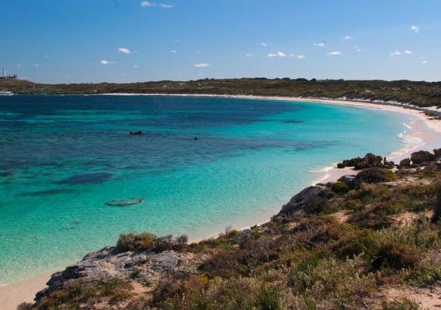
This one way trail can be started from either end. If coming from the Settlement or GeoRoadie Bay, jump on to the trail 300m after the turn off to Little Parakeet Bay. The green directional arrows will guide your way. Make the first incline for spectacular views of Lake Baghdad, Lake Vincent and Wadjemup Lighthouse; you can even have a little break and take in the beautiful view sitting on the 100% recycled plastic bench seat. Continue on towards the newly upgraded Little Armstrong Bay. This bay is renowned for its abundance of marine life and protected waters. It is a fabulous location to escape a southerly breeze, and is a romantic location to soak up a summer sunset (make sure you know your way back home though). Catherine Bay is accessible via the Karlinyah Bidi from Armstrong Point. There are beach access stairs allowing easy access to this beautiful beach. In summer this bay will be full of boats, but in winter you and the pied oyster catchers may be the only ones on the beach. City of York Bay is the site of one of Rottnest's 12 known shipwrecks. Take in the treacherous reef surrounding the bay and you will understand how this tragedy came to light. Make sure you note the magnificent anchor located at the base of the main jetty if you arrived by ferry! This was recovered from the shipwreck in 1959. There is a great picnic spot under the canopy of the trees at City of York, and a resident quokka always looking for titbits! Remember not to feed or touch our favourite little marsupial friends. There are toilets and bins available at City of York Bay. The section of trail between City of York Bay and Ricey Beach is some of the most rugged yet! Follow the markers and take care! If there is a storm brewing jump on to the road for this section and hop back on the trail at Ricey Beach. Please do not approach the osprey stack at City of York Bay. Disturbing ospreys during the breeding season can lead to them abandoning the nest. At Ricey Beach you will find another shaded picnic bench in the trees. This location is great to escape the summer sun, the winter breeze, or sandy sandwiches. Ricey Beach is common amoungst the fishing community. There are some great fishing holes, which make for some great swimming spots too. Continue on the trail heading west and you will wind your way past a couple of peaceful secluded bays. The views unfolding to the west, exposing Rocky Bay, are breathtaking. During the right weather patterns this section of the Island can be popular with surfers. If the waves are too big at Strickland Bay surf competitions have been known to be held at Stark Bay. There are bus, toilet and bin facilities at Stark Bay. The section of beach stretching the length of Stark Bay is one of the best on the Island. Kick off your shoes and walk in the shallows of the inviting turquoise waters. Time it right and you will stumble upon a raucous flock of terns basking in the sunlight on the water's edge. Can you spot all three species common to Rottnest? Caspian, Crested and Fairy tern. On arrival at Narrow Neck you can either cross over to the south side of the Island and join the Wardan Nara Bidi, hop on the bus and head to West End to see the New Zealand fur seals and West End Boardwalk, or maybe you just want to get the bus back to the Settlement and put your feet up. You can pay for tickets on the bus with cash, or collect a ticket in the settlement before you depart.
Tips
Start Point: Little Parakeet Bay, Rottnest Island
End Point: Narrow Neck, Rocky Bay
Region: Rottnest Island, Perth
For more information, a location map and GPS file please visit Trails WA.
Gallery
Got some great shots from this hike? Upload your photos here to inspire others and show off the beauty of the trail!
Click to view form >>
Submitting your photos doesn’t mean you lose ownership. You can be credited for your contributions, and you can request removal at any time.
Content use
Please don’t copy GPX files or content from this site to AllTrails or other platforms. Each trail has been personally mapped, documented, and refined to support Australia’s bushwalking and hiking community. While some details come from land managers, every listing reflects significant personal effort. This is a free, community-driven initiative—your respect helps keep it that way.
Walk map and GPX file
It looks like I don’t have a GPX file for this trail yet. If you have one to share, please email it to me! I’ll verify it against official maps before adding it to help other hikers have a safer, easier experience. Thanks for contributing to a better hiking resource.
Getting there
Getting to the trailhead: Rottnest Island.
Closest towns to this walk: Claremont, Coogee, Cottesloe, Fremantle, Mosman Park, North Coogee, Perth, Rockingham, Scarborough
Similar walks nearby
Looking for more walks in or near Rottnest Island? Try these trails with a similar difficulty grade.
Track grade
Grade 4 (Hard) - Challenging Walks for Experienced Walkers: Grade 4 on the AWTGS signifies challenging walking tracks. Bushwalking experience is recommended for these tracks, which may be long, rough, and very steep. Directional signage may be limited, requiring a good sense of navigation. These walks are suited for experienced walkers who are comfortable with steeper inclines, rougher terrain, and potentially longer distances.
Explore safe
Plan ahead and hike safely! Carry enough water, pack layers for changing conditions, and bring safety gear like a torch, PLB, and reliable communication device. Check official sources for trail updates, closures, and access requirements, and review local weather and bushfire advice. Most importantly, share your plans with someone before you go. Being prepared makes for a safer and more enjoyable hike! Stay Safe, Explore More, and Always #ExploreSafe.
Packing checklists
What you carry in your pack depends on factors like weather, terrain, and your adventure type. Not sure what to bring? My free planning, food, and packing checklists are a great starting point, covering day hikes, overnight trips, and multi-day adventures. Use them to customise your kit and always prioritise safety.
Let someone know
Before heading out, take a moment to fill out your trip intentions form. It’s a quick way to share your hike details with family or friends. If something goes wrong, they can notify emergency services, ensuring a faster response and peace of mind. Stay safe and enjoy your adventure
Suggest an edit
Spotted a change on this trail? Maybe there are new features, the route has shifted, or the trail is permanently closed. Whatever the update, I’d love your input. Your feedback helps fellow hikers stay informed and ensures that our trail info stays fresh and reliable.
Acknowledgement of Country
Trail Hiking Australia acknowledges the Traditional Owners of the lands on which we hike and pay respects to their Elders, past and present, and we acknowledge the First Nations people of other communities who may be here today.


