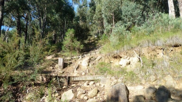
The Glosgow Track (a disused fire trail) commences where Glasgow Road intersects with Sheffield Road in Kilsyth at the foot of Mount Dandenong. Park on the street (see notes below) and walk through a gate to enter the trail. The fire trail heads straight up the side of Mount Dandenong. On the ascent the trail will cross numerous tracks that wind their way around the side of the mountain. Don't be tempted to take them. Simply head straight up the side of the mount.
As you cross each intersecting track use these as an opportunity to rest and catch your breath. There are a few other spots along the way where you can stop and have a rest, and this is where the views begin. Through the trees you start to see the town of Montrose below, and houses and factories off into the distance. On a clear day you can see right through to the CBD.
On reaching the top of the trail turn left and walk a short distance to to appreciate the views from the Kyeema Memorial Marker.
Return via the same route.
If you are keen you can repeat this trail as many times as your legs will bear.
The trail is uneven and rocky so take your time and watch your footing.
Please don’t copy GPX files or content from this site to AllTrails or other platforms. Each trail has been personally mapped, documented, and refined to support Australia’s bushwalking and hiking community. While some details come from land managers, every listing reflects significant personal effort. This is a free, community-driven initiative—your respect helps keep it that way.
Total distance: 2100 m
Max elevation: 580 m
Min elevation: 246 m
Total climbing: 341 m
Total descent: -341 m
Getting there
Getting to the trailhead: Mount Dandenong.
Drive to Kilsyth South and along Liverpool Road. Turn onto Glasgow Road and continue past Sheffield Road to the end of Glasgow Road. There is a small, semi-official area to park your car here. Alternatively, just a bit further down, where Glasgow Road intersects with Sheffield Road. Please be respectful of the local residents though, and park only in an appropriate and safe spot.
Closest towns to this walk: Belgrave, Emerald, Kallista, Kalorama, Monbulk, Montrose, Olinda, Sassafras, Tecoma, Upwey
About the region
Mount Dandenong is nestled between the tourist towns of Olinda and Kalorama in Melbourne's bushy and scenic Dandenong Ranges. The community of Mount Dandenong itself does not have a defined commercial centre, but it does include a number of boutique restaurants and stylish accommodation establishments which are tucked away in secluded spots along forest roads.
Much of Mount Dandenong is occupied by the Dandenong Ranges National Park, which offers a vast network of walking tracks through native Australian bush in a scenic and mountainous environment. Due to the area being the closest major mountain range to Melbourne, it is home to many of the city's TV and radio transmission towers, which soar into the sky out of the surrounding forests.
Similar walks nearby
Looking for more walks in or near Mount Dandenong? Try these trails with a similar difficulty grade.
Favourite

Favourite

Favourite

Dandenong Ranges National Park
Favourite

Dandenong Ranges National Park
Track grade
Grade 3 (Moderate) - Walks for Most Fitness Levels: Grade 3 on the
AWTGS represents moderate walking tracks. These are ideal for walkers with some fitness who are comfortable with some hills and uneven terrain. While suitable for most ages, some bushwalking experience is recommended to ensure a safe and enjoyable experience. Tracks may have short, steep hill sections, a rough surface, and many steps. The total distance of a Grade 3 walk can be up to 20 kilometers.
Explore safe
Plan ahead and hike safely! Carry enough water, pack layers for changing conditions, and bring safety gear like a torch, PLB, and reliable communication device. Check official sources for trail updates, closures, and access requirements, and review local weather and bushfire advice. Most importantly, share your plans with someone before you go. Being prepared makes for a safer and more enjoyable hike! Stay Safe, Explore More, and Always #ExploreSafe.
Packing checklists
What you carry in your pack depends on factors like weather, terrain, and your adventure type. Not sure what to bring? My free planning, food, and packing checklists are a great starting point, covering day hikes, overnight trips, and multi-day adventures. Use them to customise your kit and always prioritise safety.
Let someone know
Before heading out, take a moment to fill out your trip intentions form. It’s a quick way to share your hike details with family or friends. If something goes wrong, they can notify emergency services, ensuring a faster response and peace of mind. Stay safe and enjoy your adventure
Suggest an edit
Spotted a change on this trail? Maybe there are new features, the route has shifted, or the trail is permanently closed. Whatever the update, I’d love your input. Your feedback helps fellow hikers stay informed and ensures that our trail info stays fresh and reliable.
/Glasgow-Track_1.jpg)


4 Reviews on “Glasgow Track (2.1km)”
Vaughan Bowman Tick!