Hike at a Glance
Max elevation: 431m
Min elevation: 6m
Total Ascent: 942m
Hike overview
Unveiling Multiple Waterfalls: The Erskine Falls Circuit Walk
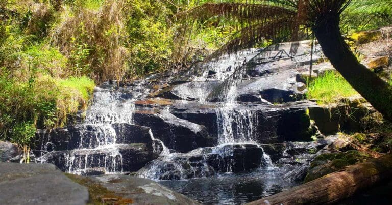
Discover a hidden cascade paradise on the Erskine Falls Circuit Walk, a captivating journey through the heart of Great Otway National Park. This extended hike goes beyond the iconic Erskine Falls, treating you to a variety of stunning waterfalls.
The Erskine Falls Circuit Walk demands dedication due to its distance, but the rewards are unmatched. Lush fern gullies and cascading waters create an unforgettable adventure.
Begin your adventure at the Allenvale Mill carpark. Follow the clear trail markers across the road, leading you towards Phantom Falls. The initial path winds across a bridge and through an orchard before following the scenic Saint George River. Keep an eye out for the turnoff to Canyon Walk on your left, but stay on the main path until you reach the descent to Phantom Falls on your right. After admiring its beauty, continue downstream and cross the bridge to tackle the next leg.
The trail weaves through Cora Lynn Creek multiple times before revealing the cascading wonder of Cora Lynn. Retrace your steps, and after roughly a kilometer, you'll encounter a turnoff to the campground on your right. Stay on the main trail, and shortly after, a junction to the Lemonade Creek trail will appear on your left. Take this detour, and after approximately 750 meters, you'll reach the main road.
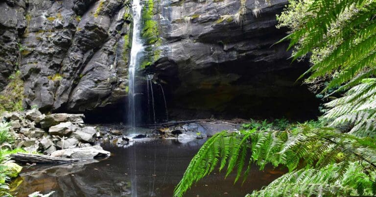
Cross the road and follow the vehicle track for roughly 250 meters. Here, you'll find the turnoff to Erskine Falls on your left. Enjoy a leisurely walk for a couple of kilometers until you reach the carpark for the falls. Descend the designated path to witness the majestic Erskine Falls in all its glory.
Ascend from the awe-inspiring Erskine Falls and follow the path downstream. The initial terrain might be slightly rugged, but the rewards are substantial. You'll encounter the cascading wonders of Straw Falls and Splitter Falls along the way. Keep following the path downstream until you reach the caravan park. Walk through it to reach the main road. Turn right, and at the roundabout, take Otway Street uphill. Once you reach the roundabout at the top, take Allenvale Road to return to the carpark, completing your Erskine Falls Circuit Walk adventure.
Tips
- The creek and river crossings can be very slippery, so take care.
- You could start this hike in the township.
- Remember your camera.
Content use
Please don’t copy GPX files or content from this site to AllTrails or other platforms. Each trail has been personally mapped, documented, and refined to support Australia’s bushwalking and hiking community. While some details come from land managers, every listing reflects significant personal effort. This is a free, community-driven initiative—your respect helps keep it that way.
Walk map and GPX file
Max elevation: 431 m
Min elevation: 6 m
Total climbing: 942 m
Total descent: -941 m
Getting there
Getting to the trailhead: Great Otway National Park.
Follow the Princes Highway (M1) from Melbourne to Geelong, then take the Great Ocean Road (B100) through Torquay to Lorne. Or follow the Princes Highway (M1) from Melbourne to Geelong to Winchelsea (A1). Then take C151 via Deans Marsh to Lorne. At the roundabout head uphill on Otway Street. When you reach the roundabout at the top take Allenvale Road back to the carpark.
Closest towns to this walk: Apollo Bay, Beech Forest, Colac, Forrest, Lavers Hill, Lorne, Skenes Creek, Wye River
About the region
Unveil the Majesty of Great Otway National Park
Stretch along the iconic Great Ocean Road, Great Otway National Park in southern Victoria, Australia, boasts a tapestry of landscapes. Traverse windswept coastlines, encounter cascading waterfalls amidst towering mountain forests, or delve into the temperate rainforests on boardwalks at Maits Rest. Hike sections of the Great Ocean Walk, a multi-day adventure that winds through the park towards the awe-inspiring Twelve Apostles rock formations.
History buffs can immerse themselves in the 1848 Cape Otway Lightstation, perched dramatically on cliffs overlooking Bass Strait. Nature lovers will find solace by the cascading Triplet Falls or exploring the diverse range of wildlife the park protects, including koalas, echidnas, and colorful parrots.
Similar walks nearby
Looking for more walks in or near Great Otway National Park? Try these trails with a similar difficulty grade.
Track grade
Grade 4 (Hard) - Challenging Walks for Experienced Walkers: Grade 4 on the AWTGS signifies challenging walking tracks. Bushwalking experience is recommended for these tracks, which may be long, rough, and very steep. Directional signage may be limited, requiring a good sense of navigation. These walks are suited for experienced walkers who are comfortable with steeper inclines, rougher terrain, and potentially longer distances.
Explore safe
Plan ahead and hike safely! Carry enough water, pack layers for changing conditions, and bring safety gear like a torch, PLB, and reliable communication device. Check official sources for trail updates, closures, and access requirements, and review local weather and bushfire advice. Most importantly, share your plans with someone before you go. Being prepared makes for a safer and more enjoyable hike! Stay Safe, Explore More, and Always #ExploreSafe.
Packing checklists
What you carry in your pack depends on factors like weather, terrain, and your adventure type. Not sure what to bring? My free planning, food, and packing checklists are a great starting point, covering day hikes, overnight trips, and multi-day adventures. Use them to customise your kit and always prioritise safety.
Let someone know
Before heading out, take a moment to fill out your trip intentions form. It’s a quick way to share your hike details with family or friends. If something goes wrong, they can notify emergency services, ensuring a faster response and peace of mind. Stay safe and enjoy your adventure
Suggest an edit
Spotted a change on this trail? Maybe there are new features, the route has shifted, or the trail is permanently closed. Whatever the update, I’d love your input. Your feedback helps fellow hikers stay informed and ensures that our trail info stays fresh and reliable.
Acknowledgement of Country
Trail Hiking Australia acknowledges the Traditional Owners of the lands on which we hike and pay respects to their Elders, past and present, and we acknowledge the First Nations people of other communities who may be here today.
/Erskine-Falls-Circuit-Walk_14.jpg)
/Erskine-Falls-Circuit-Walk_25.jpg)
/Erskine-Falls-Circuit-Walk_9.jpg)
/Erskine-Falls-Circuit-Walk_19.jpg)
/Erskine-Falls-Circuit-Walk_4.jpg)
/Erskine-Falls-Circuit-Walk_20.jpg)
/Erskine-Falls-Circuit-Walk_28.jpg)
/Erskine-Falls-Circuit-Walk_22.jpg)
/Erskine-Falls-Circuit-Walk_13.jpg)
/Erskine-Falls-Circuit-Walk_18.jpg)
/Erskine-Falls-Circuit-Walk_21.jpg)
/Erskine-Falls-Circuit-Walk_17.jpg)
/Erskine-Falls-Circuit-Walk_10.jpg)
/Erskine-Falls-Circuit-Walk_27.jpg)
/Erskine-Falls-Circuit-Walk_26.jpg)


3 Reviews on “Erskine Falls Circuit Walk (23km)”
This hike is a long but incredibly rewarding day out. The waterfalls and cascades along the way really enhance the experience, and the natural surroundings are nothing short of stunning – from the misty fairy-like atmosphere to the towering ferns. We spotted plenty of mushrooms and beautiful orchids, adding to the charm of the trail. It was a bit of an adventurous and challenging hike, especially after the rain, which left the rocks slippery and tricky to navigate. It definitely made things more challenging, but the beauty of the hike more than made up for it.
Tim Dare, we should run this.
Maddison Ruggiero Adeline Dickson Jessie Roder
Josh O’Hare
Kerryn.Nicole..
Looks like a good day trek. Same distance as our second day on Kumano Kodo. Fair drive tho. Junies Ben
Mark Bolger that’s a good one to do!
James Goonan
Kate Moore
Hey just wondering is there anywhere along the track to spend a night and do this over two days