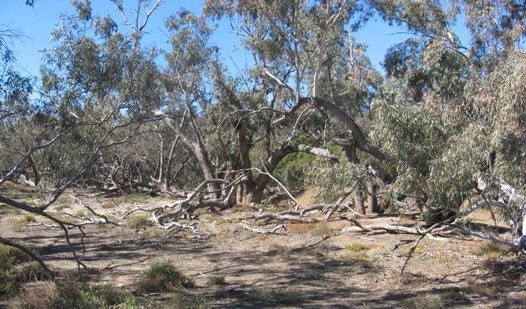
Thanks to the Jolly Swagman and his billabong, coolabah trees are iconic in Australian folklore. Culgoa Connellys track has loads of them - in fact, it threads for 4km through open coolabah woodlands, with birds circling overhead and emus rushing through scrub along the track. After rainy season, the ground blooms with native wildflowers, too.
Reached from Culgoa River campground, Culgoa Connellys track is suitable for everybody, from families and grey nomads to experienced bushwalkers. Bring plenty of water, sturdy shoes, and that all-important sense of adventure, and this easy walk delivers plenty of rewards. While it's Grade 5 for not having directional signage, you'll still find this an easy walk for all ages.
If you're river camping, consider bringing a torch as a great deal of wildlife is most active at night. So, follow the track in the evening for a completely different experience to a chorus of frogs and cicadas. You might like to look up for a bit of amateur astronomy while you're at it.
You can even extend the stroll by following the adjoining Yawura Yarun (Sandhill track), which offers a return walk to the campground as well.
The small townships of Weilmoringle, on the south-west side of Culgoa, and Goodooga, on the east side of Culgoa, offer no fuel, so please ensure you have enough before departure.
Remember to take your binoculars if you want to birdwatch
Visit NSW National Parks and Wildlife Service for more information on this trail.
The longitude and latitude of the start and end points are approximately only and should not be used for navigation purposes. Please contact me if you know the correct coordinates.
Got some great shots from this hike? Upload your photos here to inspire others and show off the beauty of the trail!
Submitting your photos doesn’t mean you lose ownership. You can be credited for your contributions, and you can request removal at any time.
Please don’t copy GPX files or content from this site to AllTrails or other platforms. Each trail has been personally mapped, documented, and refined to support Australia’s bushwalking and hiking community. While some details come from land managers, every listing reflects significant personal effort. This is a free, community-driven initiative—your respect helps keep it that way.
It looks like I don’t have a GPX file for this trail yet. If you have one to share, please email it to me! I’ll verify it against official maps before adding it to help other hikers have a safer, easier experience. Thanks for contributing to a better hiking resource.
Getting there
Getting to the trailhead: Culgoa National Park.
Culgoa Connellys track starts from Culgoa River campground in the Burban Grange precinct of Culgoa National Park. To get there:Take the unsealed road north-east of Bourke for 180km, or the unsealed, dry weather road north of Brewarrina for 120km.The campground is 14km from the southern entrance of the park Road quality Check the weather before you set out as the road to Culgoa National Park can become boggy when it rains and the roads are susceptible to flooding. Parking Parking is available at Culgoa River campground.
Closest towns to this walk: Bourke, Brewarrina, Cobar, Cunnamulla, Dirranbandi, Enngonia, Louth, Nyngan, Walgett, Wanaaring
About the region
Culgoa National Park in the Outback NSW region
Culgoa National Park is always open, but may have to close at times due to poor weather or fire danger.
Similar walks nearby
Looking for more walks in or near Culgoa National Park? Try these trails with a similar difficulty grade.
Favourite

Favourite

Favourite

Favourite

Mount Kaputar National Park
Track grade
Grade 5 (Difficult) - Walks for the Most Experienced: Grade 5 represents the most challenging walking tracks on the
AWTGS. These are only recommended for very experienced and fit walkers with specialised skills, including navigation and emergency first aid. Tracks are likely to be very rough, very steep, and unmarked. Walks may be more than 20 kilometers. These challenging walks demand a high level of fitness and experience to navigate difficult terrain, significant elevation changes, and potentially unformed paths.
Explore safe
Plan ahead and hike safely! Carry enough water, pack layers for changing conditions, and bring safety gear like a torch, PLB, and reliable communication device. Check official sources for trail updates, closures, and access requirements, and review local weather and bushfire advice. Most importantly, share your plans with someone before you go. Being prepared makes for a safer and more enjoyable hike! Stay Safe, Explore More, and Always #ExploreSafe.
Packing checklists
What you carry in your pack depends on factors like weather, terrain, and your adventure type. Not sure what to bring? My free planning, food, and packing checklists are a great starting point, covering day hikes, overnight trips, and multi-day adventures. Use them to customise your kit and always prioritise safety.
Let someone know
Before heading out, take a moment to fill out your trip intentions form. It’s a quick way to share your hike details with family or friends. If something goes wrong, they can notify emergency services, ensuring a faster response and peace of mind. Stay safe and enjoy your adventure
Suggest an edit
Spotted a change on this trail? Maybe there are new features, the route has shifted, or the trail is permanently closed. Whatever the update, I’d love your input. Your feedback helps fellow hikers stay informed and ensures that our trail info stays fresh and reliable.


