Hike at a Glance
Max elevation: 100m
Min elevation: 72m
Total Ascent: 43m
Hike overview
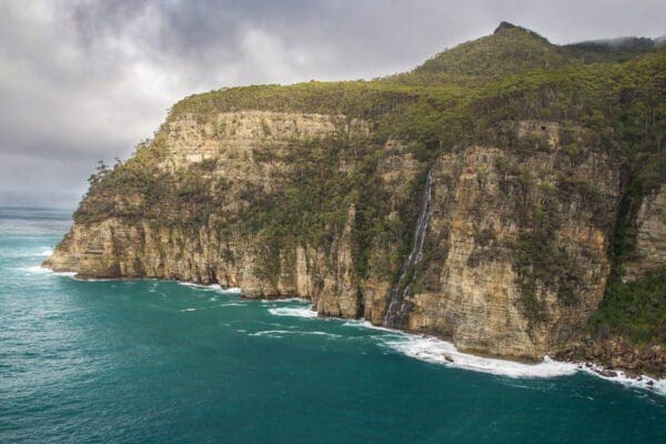
Offering remarkable coastal views of Freycinet National Park, the Cape Tourville walk is an accessible and enjoyable way for everyone to experience the area's natural beauty. The 720m, grade 1 hike loops around the automated lighthouse at Cape Tourville and typically takes around 30 minutes to complete.
The track is wide and features even surfaces with gently graded slopes, making it suitable for all levels of fitness. Much of the walk is on a raised boardwalk that, at points, brings you close to the cliff edge, providing stunning views of the Hazards, Wineglass Bay, and the offshore rocks known as The Nuggets.
The area is also rich in wildlife, with sightings of sea birds, sea-eagles, whales, seals, and dolphins being common. Bringing binoculars and a camera is recommended to fully appreciate the sights. The lighthouse at Cape Tourville was constructed in 1971 to replace the inaccessible Cape Forestier Lighthouse which was decommissioned the same year. The lighthouse was constructed as an automatic light and was never manned.
Tips
- Supervise children closely, as there are hazardous cliffs along the track. Ensure they stay within designated barriers for their safety.
- Park entry fees are required.
- Facilities including toilets, picnic areas, and electric barbecues are available 7.5km away at Ranger Creek and Honeymoon Bay.
- The track is wide with even surfaces and gently graded slopes, making it suitable for wheelchair users with assistance and walkers with strollers.
- Pets, firearms, and bicycles are not permitted in the park.
Track grade
Grade 1 (All-abilities) - Perfect for Families and Beginners: Grade 1 on the AWTGS represents the easiest walking tracks, perfect for families with young children or those new to bushwalking. No prior experience is required. These gentle walks feature a flat, even surface with no steps or steep sections. They are suitable for wheelchair users with assistance due to the even terrain. The total distance of a Grade 1 walk is typically no greater than 5 kilometers, making them a comfortable and manageable option for all ages and fitness levels.
Walk map and GPX file
Max elevation: 100 m
Min elevation: 72 m
Total climbing: 43 m
Total descent: -43 m
Content use
Please don’t copy GPX files or content from this site to AllTrails or other platforms. Each trail has been personally mapped, documented, and refined to support Australia’s bushwalking and hiking community. While some details come from land managers, every listing reflects significant personal effort. This is a free, community-driven initiative—your respect helps keep it that way.
Getting there
Getting to the trailhead: Freycinet National Park.
Freycinet National Park is located approximately 2.5 to 3 hours’ drive from either Launceston or Hobart. To reach the main park entrance and Freycinet Visitor Centre, take the Tasman Highway (A3) and turn onto Coles Bay Road (C302), situated 12km south of Bicheno. Continue on Coles Bay Road for 28km, driving through the Coles Bay township on a sealed road to arrive at the park entrance. The Peninsula Circuit walk begins from the walking tracks car park, which is about 4 kilometres further into the park from the Visitor Centre. Additionally, the Friendly Beaches section of the park is accessible via a gravel road about 9km after leaving the Tasman Highway. Public transport and tours also provide access to the park. To ensure the safety of native wildlife, it is advisable to avoid driving in the park at night and to remain vigilant for animals on the road.
Need a rental car to get you to the hike? Find one here.
Let someone know
Heading out? Fill in a trip intentions form so someone knows your plans. If things go wrong, they can raise the alarm fast, giving you peace of mind on the trail.
About the region
Freycinet National Park, located on Tasmania’s east coast, is a renowned coastal destination featuring a diverse and stunning landscape. The park, which occupies most of the Freycinet Peninsula, is famous for its dramatic pink granite peaks, secluded bays, pristine white sandy beaches, and rich wildlife. It offers a range of activities, from walking trails that lead to scenic bays and beaches to opportunities for swimming, snorkelling, and kayaking in its inviting waters.
The park’s main area covers the southern tip of the Freycinet Peninsula and extends along its east coast, encompassing the Friendly Beaches and stretching almost to the coastal town of Bicheno. Freycinet, along with Mount Field, holds the distinction of being one of Tasmania’s oldest national parks.
Wineglass Bay, the park’s most iconic feature, is a perfect crescent of white sand nestled beneath the Hazards mountains. This beach is one of Tasmania’s most celebrated natural attractions, drawing visitors from around the world. The Hazards, a striking line of granite peaks, form a dramatic barrier across the park, with the Wineglass Bay Lookout offering breathtaking views from one of the passes.
The Friendly Beaches, lining the peninsula’s east coast, present a stunning contrast of white sand and blue sea, while Cape Tourville, topped with a lighthouse and ringed by a boardwalk, offers glimpses into Wineglass Bay and opportunities to spot marine life, including whales.
Freycinet National Park’s appeal lies not only in the beauty of Wineglass Bay but also in the variety of its coastal landscapes. The park’s terrain ranges from rocky coves and surging surf to sheltered bays and serene beaches, all set against the backdrop of the Hazards’ granite peaks. Despite its popularity, the park still offers moments of solitude and a wide range of experiences.
The park, jutting out into the sea, is home to a rich array of plants and animals, protected within the rugged and beautiful Freycinet Peninsula. The scenic beauty and diverse activities available make it a popular destination for visitors, especially during the summer months. Whether you choose to walk to the pass overlooking Wineglass Bay, undertake the three-day trek across the Freycinet Peninsula, kayak to secluded beaches, or enjoy more leisurely pursuits like beach strolls, swimming, fishing, birdwatching, or wildlife spotting, Freycinet offers something for everyone.
Similar walks nearby
Looking for more walks in or near Freycinet National Park? Try these trails with a similar difficulty grade.
Explore safe
Plan ahead and hike safely! Carry enough water, pack layers for changing conditions, and bring safety gear like a torch, PLB, and reliable communication device. Check official sources for trail updates, closures, and access requirements, and review local weather and bushfire advice. Most importantly, share your plans with someone before you go. Being prepared makes for a safer and more enjoyable hike! Stay Safe, Explore More, and Always #ExploreSafe.
Packing checklists
What you carry in your pack depends on factors like weather, terrain, and your adventure type. Not sure what to bring? My free planning, food, and packing checklists are a great starting point, covering day hikes, overnight trips, and multi-day adventures. Use them to customise your kit and always prioritise safety.
Suggest an edit
Notice something different about this trail? Whether it’s a new feature, a route change, or a closure, share your update so we can keep our info accurate and helpful for fellow hikers.
Click to suggest edits >>
Acknowledgement of Country
Trail Hiking Australia acknowledges the Traditional Owners of the lands on which we hike and pay respects to their Elders, past and present, and we acknowledge the First Nations people of other communities who may be here today.
/Cape-Tourville-Walk_8.jpg)
/Cape-Tourville-Walk_4.jpg)
/Cape-Tourville-Walk_5.jpg)
/Cape-Tourville-Walk_2.jpg)
/Cape-Tourville-Walk_7.jpg)
/Cape-Tourville-Walk_6.jpg)
/Cape-Tourville-Walk_9.jpg)
/Cape-Tourville-Walk_1.jpg)
/Cape-Tourville-Walk_3.jpg)


