Hike at a Glance
Max elevation: 180m
Min elevation: 12m
Total Ascent: 550m
Hike overview
You can get a great view of Cape Hauy in the spectacular Tasman National Park as you travel to the Tasman Peninsula. To get this view, make a short detour, from the Arthur Highway (A9), to the Pirates Bay lookout just before Eaglehawk Neck. The walk to Cape Hauy leaves from Fortescue Bay 15km further south.
Highlights
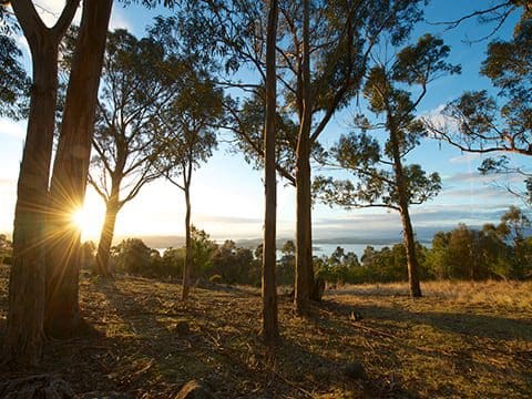
The Cape Hauy Track leads from Fortescue Bay, just near the boat ramp. The walk passes through a variety of heath and woodland before coming to the magnificent views of steep cliffs and rock formations.
The spectacular dolerite columns and cliffs at Cape Hauy are popular areas for climbing and abseiling. Sea stacks, the "Candlestick" and "Totem Pole" at Cape Hauy are used by climbers and are not, you may be pleased to know, a part of this short walk!
Tips
Park entry fees apply.
Camping, boat ramp, drinking water, picnic and toilet facilities available at Fortescue Bay.
Supervise children, unpatrolled beach, unprotected track edges.
No pets, firearms or bicycles.
Gallery
Got some great shots from this hike? Upload your photos here to inspire others and show off the beauty of the trail!
Click to view form >>
Submitting your photos doesn’t mean you lose ownership. You can be credited for your contributions, and you can request removal at any time.
Content use
Please don’t copy GPX files or content from this site to AllTrails or other platforms. Each trail has been personally mapped, documented, and refined to support Australia’s bushwalking and hiking community. While some details come from land managers, every listing reflects significant personal effort. This is a free, community-driven initiative—your respect helps keep it that way.
Walk map and GPX file
Max elevation: 180 m
Min elevation: 12 m
Total climbing: 550 m
Total descent: -550 m
For more information about this hiking trail please visit Parks and Wildlife Service Tasmania
Getting there
Getting to the trailhead: Tasman National Park.
Arthur Highway (A9) to junction with Fortescue Bay road (C344) which is 4km south of Taranna and 4km north of Port Arthur. Turn into C344 and drive 12km to Fortescue Bay. (This road is unsealed but is suitable for 2WD vehicles and mountain bikes).
Closest towns to this walk: Dunalley, Eaglehawk Neck, Nubeena, Port Arthur, Sorell, Taranna
About the region
Tasman National Park is a wild, yet accessible park of tall forests and a truly spectacular coastline. Waters from the Southern Ocean collide with the towering sea cliffs of the Tasman Peninsula, creating spectacular rock formations, including caves and arches. The coastal vegetation grows precariously close to the edges of the cliffs, creating a blanket of green that contrasts with the surging surf below. Australia's highest sea cliffs have walkers on the award-winning, multi-day Three Capes Track in awe. Day walkers can also discover a slice of this beauty high atop the cliffs on shorter coastal walks at Cape Hauy, Cape Raoul and the world-famous big wave mecca, Shipsterns Bluff.
Similar walks nearby
Looking for more walks in or near Tasman National Park? Try these trails with a similar difficulty grade.
Track grade
Grade 4 (Hard) - Challenging Walks for Experienced Walkers: Grade 4 on the AWTGS signifies challenging walking tracks. Bushwalking experience is recommended for these tracks, which may be long, rough, and very steep. Directional signage may be limited, requiring a good sense of navigation. These walks are suited for experienced walkers who are comfortable with steeper inclines, rougher terrain, and potentially longer distances.
Explore safe
Plan ahead and hike safely! Carry enough water, pack layers for changing conditions, and bring safety gear like a torch, PLB, and reliable communication device. Check official sources for trail updates, closures, and access requirements, and review local weather and bushfire advice. Most importantly, share your plans with someone before you go. Being prepared makes for a safer and more enjoyable hike! Stay Safe, Explore More, and Always #ExploreSafe.
Packing checklists
What you carry in your pack depends on factors like weather, terrain, and your adventure type. Not sure what to bring? My free planning, food, and packing checklists are a great starting point, covering day hikes, overnight trips, and multi-day adventures. Use them to customise your kit and always prioritise safety.
Let someone know
Before heading out, take a moment to fill out your trip intentions form. It’s a quick way to share your hike details with family or friends. If something goes wrong, they can notify emergency services, ensuring a faster response and peace of mind. Stay safe and enjoy your adventure
Suggest an edit
Spotted a change on this trail? Maybe there are new features, the route has shifted, or the trail is permanently closed. Whatever the update, I’d love your input. Your feedback helps fellow hikers stay informed and ensures that our trail info stays fresh and reliable.
Acknowledgement of Country
Trail Hiking Australia acknowledges the Traditional Owners of the lands on which we hike and pay respects to their Elders, past and present, and we acknowledge the First Nations people of other communities who may be here today.


