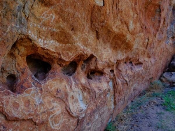
A walk along this trail in the early morning showcases a beautiful landscape of colour changes and is an opportunity to discover some iconic Pilbara wildflowers, such as Sturt's desert pea, mulla mulla's and the holly leafed grevillea.. Enjoy the stunning view of the Chichester Ranges from the lookout at the top of Mount Herbert.
The Camel Trail starts at pretty Python Pool, a permanent water hole (perfect for a swim) surrounded by sheer red rock walls. The trail follows part of the old camel road, winding up the rugged sandstone escarpment of the Chichester Ranges, through rolling spinifex covered hills, large termite mounds and passing McKenzie Spring before heading to the base of Mount Herbert. With fewer visitors and less facilities than near by Karijini National Park, the Chichester Ranges are remote and spectacular. There are many special features of this trail including the historical aspect. It was used to deliver stores to isolated stations and return wool clip to ports like Cossack. McKenzie Spring was a watering hole along the route. Located in spinifex country, with plenty of snappy gums, reptiles and Birdlife to view, it has a spectacular panoramic landscape, and beautiful swimming opportunities in Python Pool. If you decide to complete the one way walk, start at Mount Herbert and have a vehicle meet you at Python Pool. If completing the return walk, begin at Python Pool.
Start Point: Python Pool Car Park, Millstream-Chichester National Park, 2 hours from Karratha which is 1500km (19 hours) north of Perth
End Point: Python Pool Car Park, Millstream-Chichester National Park, 2 hours from Karratha which is 1500km (19 hours) north of Perth
Region: Chichester Ranges, North West
For more information, a location map and GPS file please visit Trails WA.
Grade 3 (Moderate) - Walks for Most Fitness Levels: Grade 3 on the
AWTGS represents moderate walking tracks. These are ideal for walkers with some fitness who are comfortable with some hills and uneven terrain. While suitable for most ages, some bushwalking experience is recommended to ensure a safe and enjoyable experience. Tracks may have short, steep hill sections, a rough surface, and many steps. The total distance of a Grade 3 walk can be up to 20 kilometers.
Do you have a GPX file for this hike? Feel free to email it to me so I can add it to this hikes info.
Click to add your file >>
Content use
Please don’t copy GPX files or content from this site to AllTrails or other platforms. Each trail has been personally mapped, documented, and refined to support Australia’s bushwalking and hiking community. While some details come from land managers, every listing reflects significant personal effort. This is a free, community-driven initiative—your respect helps keep it that way.
Gallery
Got any photos from this hike? Your photos can help others plan. Share shots from along the trail so fellow hikers know what to expect.
Click to add your photos >>
Let someone know
Heading out? Fill in a trip intentions form so someone knows your plans. If things go wrong, they can raise the alarm fast, giving you peace of mind on the trail.
About the region
The Chichester Range is a range in the Pilbara region of Western Australia. The range rises abruptly from the coastal plain and is composed of rolling hills, escarpments, jagged peaks, gorges and winding tree-lined watercourses.
Similar walks nearby
Looking for more walks in or near Chichester Ranges? Try these trails with a similar difficulty grade.
Favourite

Favourite

Mount Augustus National Park
Favourite

Mount Augustus National Park
Favourite

Mount Augustus National Park
Explore safe
Plan ahead and hike safely! Carry enough water, pack layers for changing conditions, and bring safety gear like a torch, PLB, and reliable communication device. Check official sources for trail updates, closures, and access requirements, and review local weather and bushfire advice. Most importantly, share your plans with someone before you go. Being prepared makes for a safer and more enjoyable hike! Stay Safe, Explore More, and Always #ExploreSafe.
Packing checklists
What you carry in your pack depends on factors like weather, terrain, and your adventure type. Not sure what to bring? My free planning, food, and packing checklists are a great starting point, covering day hikes, overnight trips, and multi-day adventures. Use them to customise your kit and always prioritise safety.
Suggest an edit
Notice something different about this trail? Whether it’s a new feature, a route change, or a closure, share your update so we can keep our info accurate and helpful for fellow hikers.
Click to suggest edits >>


