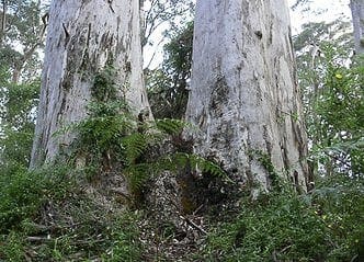
Just seven kilometres from Walpole yet deep in the heart of outstandingly beautiful tingle and karri forest, the Giant Tingle Tree is the site of a huge fire-hollowed red tingle tree.
Opposite Knoll Drive, Hilltop Road winds through a very special red tingle and Karri forest. Two kilometres along this one-way road will bring you to a spectacular lookout over the Frankland River, Nornalup Inlet and Southern Ocean. Three kilometres after the lookout will bring you to the Car Park of the Giant Tingle Tree. From here starts an 800m circular walk which leads down to the Giant Tingle Tree and the boaRoad walk that protects it. At 24 metres, this is the largest, living, girthed eucalypt known in the world. Access is via a wooden Boardwalk around the base of this Queen of Trees. This is an opportunity to explore this wilderness, learning as you go. The signposts have great information about the flora and fauna of this native forest of the south coast. This Hollowbutt sign explains how the heartwood is burned from the trees and how the outer layer sustains these giant trees. Amazing! Expore the forest along the Giant Tree Loop Walk and enjoy a picnic amongst the beautiul tingle and karri forrest. This is a popular stop whist traveling along the Hill Top Scenic Drive east of Walpole which can be accessed from the South Coast Highway. The road into the Giant Tingle Tree site is gravel and accessible by two-wheel drive vehicles. Not suitable if towing a caravan.
Start Point: Opposite Knoll Drive of Hilltop Road, 416km (4.5 hours) south of Perth
End Point: Opposite Knoll Drive of Hilltop Road, 416km (4.5 hours) south of Perth
Region: Walpole, South West
For more information, a location map and GPS file please visit Trails WA.
Got some great shots from this hike? Upload your photos here to inspire others and show off the beauty of the trail!
Submitting your photos doesn’t mean you lose ownership. You can be credited for your contributions, and you can request removal at any time.
Please don’t copy GPX files or content from this site to AllTrails or other platforms. Each trail has been personally mapped, documented, and refined to support Australia’s bushwalking and hiking community. While some details come from land managers, every listing reflects significant personal effort. This is a free, community-driven initiative—your respect helps keep it that way.
It looks like I don’t have a GPX file for this trail yet. If you have one to share, please email it to me! I’ll verify it against official maps before adding it to help other hikers have a safer, easier experience. Thanks for contributing to a better hiking resource.
Getting there
Getting to the trailhead: Tingle Tree Reserve.
Closest towns to this walk: Bow Bridge, Denmark, Nornalup, Peaceful Bay, Walpole
Similar walks nearby
Looking for more walks in or near Tingle Tree Reserve? Try these trails with a similar difficulty grade.
Favourite

Favourite

Favourite

Favourite

Track grade
Grade 2 (Easy) - A Gentle Introduction to Inclines: Grade 2 on the
AWTGS represents easy walking tracks that offer a slightly more challenging experience compared to Grade 1. Similar to Grade 1, no prior bushwalking experience is required. The track surface is typically hardened or compacted and may have gentle hill sections or occasional steps. The total distance of a Grade 2 walk is typically no greater than 10 kilometers. These walks are still suitable for families with a bit more experience or those seeking a gentle introduction to some inclines.
Explore safe
Plan ahead and hike safely! Carry enough water, pack layers for changing conditions, and bring safety gear like a torch, PLB, and reliable communication device. Check official sources for trail updates, closures, and access requirements, and review local weather and bushfire advice. Most importantly, share your plans with someone before you go. Being prepared makes for a safer and more enjoyable hike! Stay Safe, Explore More, and Always #ExploreSafe.
Packing checklists
What you carry in your pack depends on factors like weather, terrain, and your adventure type. Not sure what to bring? My free planning, food, and packing checklists are a great starting point, covering day hikes, overnight trips, and multi-day adventures. Use them to customise your kit and always prioritise safety.
Let someone know
Before heading out, take a moment to fill out your trip intentions form. It’s a quick way to share your hike details with family or friends. If something goes wrong, they can notify emergency services, ensuring a faster response and peace of mind. Stay safe and enjoy your adventure
Suggest an edit
Spotted a change on this trail? Maybe there are new features, the route has shifted, or the trail is permanently closed. Whatever the update, I’d love your input. Your feedback helps fellow hikers stay informed and ensures that our trail info stays fresh and reliable.


