Hike at a Glance
Max elevation: 966m
Min elevation: 793m
Total Ascent: 385m
Hike overview
Take a scenic 1.5km walk in the Blue Mountains National Park vie Echo Point lookout to the iconic Three Sisters rock formation. This moderate (grade 2) walk offers stunning views of the Jamison Valley and surrounding mountains.
The Three Sisters Walk takes you past the scenic overlooks of Price of Wales lookout, Queen Elizabeth lookout to Echo Point before taking you on a longer journey to the Three Sisters via Spooners, Oreades, Lady Game and Honeymoon Bridge lookouts.
From the front of the Echo Point Visitor Center and mobility car parking area, this walk heads gently downhill towards Price of Wales lookout before arriving at the formal Echo Point lookout for stunning views.
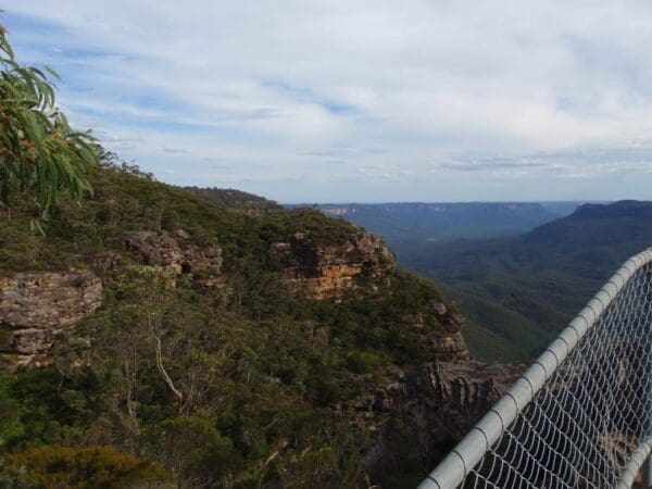
A photographer's paradise, Echo Point is the most popular lookout in the Blue Mountains, attracting over two million visitors annually. Framed by sturdy fences for safety, the platform offers breathtaking panoramas of the Three Sisters and majestic Mount Solitary across the Jamison Valley. Informative signs enhance the experience, while mounted binoculars and nearby seating allow you to relax and soak in the grandeur of the landscape.
From Echo Point, head north a short distance to pick up the Three Sisters walking track. This well-marked path leads you to Spooners Lookout, offering the first glimpse of the Jamison Valley's grandeur. Here, soak in panoramic views encompassing the Three Sisters and majestic Mount Solitary. The lookout features a large seating area, sturdy fencing for safety, and is designed to provide comfortable enjoyment for visitors using wheelchairs.
Continue along the Three Sisters track, taking in the ever-changing views from each subsequent lookout. Honeymoon Lookout offers a final, breathtaking perspective before your return journey. Honeymoon Bridge is currently closed for safety reasons. To return to the trailhead, retrace your steps back to the Echo Point Visitor Center.
Tips
- The Three Sisters Aboriginal Place is recognised as a place of special cultural significance to Aboriginal people
- The Visitor Information Centre at Echo Point is a good place for local information and to pick up maps
- Weather in the Blue Mountains can be very different to Sydney. Be prepared for colder temperatures as conditions can change quickly.
- This walk is accessible, with assistance, from Echo Point to Oreades lookout. Access to Honeymoon Bridge involves sections of steep stairs. Please take care.
- During busy summer, weekend, and holiday periods, there may be a waiting line to descend the Giant Stairway to Honeymoon Bridge.
Track grade
Grade 2 (Easy) - A Gentle Introduction to Inclines: Grade 2 on the AWTGS represents easy walking tracks that offer a slightly more challenging experience compared to Grade 1. Similar to Grade 1, no prior bushwalking experience is required. The track surface is typically hardened or compacted and may have gentle hill sections or occasional steps. The total distance of a Grade 2 walk is typically no greater than 10 kilometers. These walks are still suitable for families with a bit more experience or those seeking a gentle introduction to some inclines.
Walk map and GPX file
Max elevation: 966 m
Min elevation: 793 m
Total climbing: 385 m
Total descent: -398 m
Content use
Please don’t copy GPX files or content from this site to AllTrails or other platforms. Each trail has been personally mapped, documented, and refined to support Australia’s bushwalking and hiking community. While some details come from land managers, every listing reflects significant personal effort. This is a free, community-driven initiative—your respect helps keep it that way.
Gallery
Got any photos from this hike? Your photos can help others plan. Share shots from along the trail so fellow hikers know what to expect.
Click to add your photos >>
Getting there
Getting to the trailhead: Blue Mountains National Park.
Getting to the Three Sisters Walk:
The walk starts conveniently at Echo Point in Katoomba, within the Blue Mountains National Park.
- By Car: Take the Great Western Highway towards Katoomba. Keep an eye out for signs directing you to Echo Point and the Three Sisters as you get closer. Once in Katoomba, follow these signs to designated car parks or street parking around Echo Point.
- Parking: Paid parking is available in car parks and on streets near Echo Point, with some designated disabled spots. Be aware of council parking fees and time limits, especially on weekends when parking can be busy. You might need to walk a short distance if spots close by are full.
Consider arriving early on weekends or during peak season to secure closer parking.
Need a rental car to get you to the hike? Find one here.
About the region
Katoomba area is the heart of Blue Mountains National Park, is a paradise for nature lovers. Hike alongside world-class views and waterfalls like Wentworth Falls. Witness the iconic Three Sisters at Echo Point, or challenge yourself on the multi-day Grand Cliff Top Walk.
From gentle strolls to exciting clifftop walks like Prince Henry Cliff Walk, Katoomba caters to all. Explore the cool rainforest on the Round Walk or take a ride on Scenic World. For a historical touch, descend the Giant Stairway.
Head to Wentworth Falls for breathtaking lookouts and cascading waterfalls. Enjoy a picnic amidst nature's serenade, then explore hidden trails or relax in the Valley of the Waters.
Thrill-seekers can cycle Narrow Neck, try abseiling, or conquer the legendary Six Foot Track. Mountain bikers can explore Kings Tableland, while campers can find remote adventures.
Find a place to stay
Wondering where to stay near this hike? Find accommodation close to the trailhead — hotels, cabins and campgrounds nearby. Click the button to view the interactive map.
Closest towns to this walk: Blackheath, Bullaburra, Hazelbrook, Katoomba, Lawson, Leura, Lithgow, Mount Victoria, Springwood, Wentworth Falls, Woodford
Let someone know
Heading out? Fill in a trip intentions form so someone knows your plans. If things go wrong, they can raise the alarm fast, giving you peace of mind on the trail.
Similar walks nearby
Looking for more walks in or near Blue Mountains National Park? Try these trails with a similar difficulty grade.
Suggest an edit
Notice something different about this trail? Whether it’s a new feature, a route change, or a closure, share your update so we can keep our info accurate and helpful for fellow hikers.
Click to suggest edits >>
Explore safe
Plan ahead and hike safely! Carry enough water, pack layers for changing conditions, and bring safety gear like a torch, PLB, and reliable communication device. Check official sources for trail updates, closures, and access requirements, and review local weather and bushfire advice. Most importantly, share your plans with someone before you go. Being prepared makes for a safer and more enjoyable hike! Stay Safe, Explore More, and Always #ExploreSafe.
Packing checklists
What you carry in your pack depends on factors like weather, terrain, and your adventure type. Not sure what to bring? My free planning, food, and packing checklists are a great starting point, covering day hikes, overnight trips, and multi-day adventures. Use them to customise your kit and always prioritise safety.
Acknowledgement of Country
Trail Hiking Australia acknowledges the Traditional Owners of the lands on which we hike and pay respects to their Elders, past and present, and we acknowledge the First Nations people of other communities who may be here today.


