Hike at a Glance
Max elevation: 825m
Min elevation: 541m
Total Ascent: 306m
Hike overview
The Paradise Falls to McMillan's Lookout track offers a challenging 9km return hike for those seeking more than just a glimpse of the cascading falls in Victoria's Alpine National Park. This grade 3 trail takes approximately 3-4 hours to complete and leads from the Paradise Falls car park to McMillan's Track Lookout on the Wobonga Plateau.
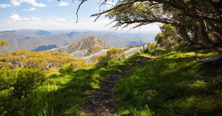
The initial section involves a steady 2.9km climb along the well-maintained Paradise Falls Track. At a designated junction, you'll take a right turn westward and continue for another 1.6km. This final leg culminates at McMillan's Track Lookout, where you'll be rewarded with stunning panoramic views. Take in the expansive landscape encompassing the Upper King River, Lake William Hovel, and the rolling hills that gradually rise towards the majestic peaks of Mount Stirling and Mount Buller.
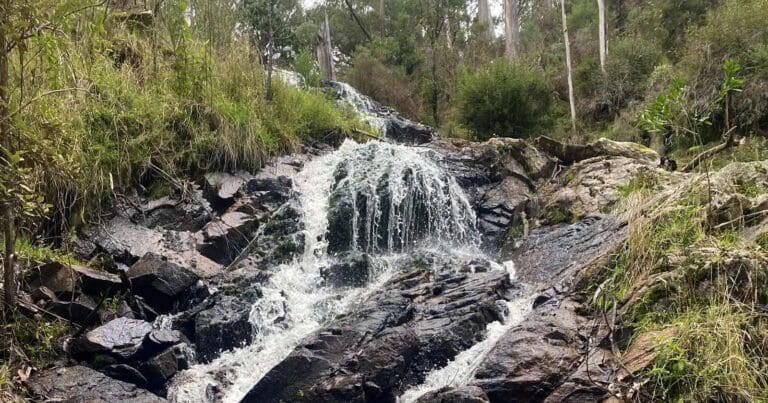
For those seeking a shorter option, the 1km return walk to Paradise Falls itself is a worthwhile detour. The well-constructed, stepped track is suitable for most fitness levels, and the 500-metre walk leads to a viewing platform overlooking the cascading water. For the most spectacular display, plan your visit during spring, early summer, or after significant rainfall.
Gallery
Got some great shots from this hike? Upload your photos here to inspire others and show off the beauty of the trail!
Click to view form >>
Submitting your photos doesn’t mean you lose ownership. You can be credited for your contributions, and you can request removal at any time.
Content use
Please don’t copy GPX files or content from this site to AllTrails or other platforms. Each trail has been personally mapped, documented, and refined to support Australia’s bushwalking and hiking community. While some details come from land managers, every listing reflects significant personal effort. This is a free, community-driven initiative—your respect helps keep it that way.
Walk map and GPX file
Max elevation: 825 m
Min elevation: 541 m
Total climbing: 306 m
Total descent: -306 m
Getting there
Getting to the trailhead: Alpine National Park.
Reaching the Paradise Falls carpark in Alpine National Park is straightforward. Head to the charming town of Whitfield in Victoria’s King Valley. From there, a scenic 20-minute drive on well-maintained gravel roads leads you directly to the carpark at the end of Paradise Falls Road. The final leg offers glimpses of picturesque countryside, so keep an eye out for those views. Upon arrival, you’ll find convenient parking and picnic tables, perfect for enjoying a packed lunch or grabbing a bite from nearby Whitfield before exploring the cascading falls and the surrounding beauty.
Closest towns to this walk: Benalla, Bright, Dinner Plain, Falls Creek, Harrietville, Hotham Heights, Mansfield, Mitta Mitta, Mount Beauty, Mount Hotham, Myrtleford, Omeo, Porepunkah, Tawonga South, Wangaratta
About the region
The Alpine National Park holds deep cultural significance for the Taungurung and Gunaikurnai Peoples, the traditional custodians of this land.
Victoria's Alpine National Park, the state's largest, offers a breathtaking escape year-round. Nestled amongst Victoria's highest mountains, the park boasts diverse landscapes teeming with flora and fauna adapted to its climatic extremes.
During the warmer months, the park transforms into a haven for outdoor enthusiasts. Hike through vibrant wildflower displays, explore on horseback, or challenge yourself on world-class mountain bike trails. For a truly immersive experience, embark on the Falls to Hotham Alpine Crossing, traversing towering ridges, lush valleys, and unforgettable alpine scenery. History buffs can delve into the High Country's rich heritage along the Wonnangatta Four-wheel Drive track, winding through rugged bushland and majestic mountains.
For the adventurous, exciting opportunities abound. Conquer Victoria's second-highest peak, Mount Feathertop, along the dramatic Razorback track, or tackle the challenging ascent of Mount Bogong, the state's highest point. Explore the Bogong High Plains, where historic huts stand as testaments to the region's past, or get your adrenaline pumping with white-water rafting down the Mitta Mitta River.
Come winter, the park transforms into a skier's paradise. From well-groomed downhill slopes to challenging cross-country trails and untouched backcountry terrain, Alpine National Park caters to all levels of skiers and snowboarders.
With its diverse activities, stunning landscapes, and rich history, Alpine National Park offers an unforgettable experience for all visitors. Remember to research specific tracks and activities before your visit to ensure a safe and enjoyable time.
Similar walks nearby
Looking for more walks in or near Alpine National Park? Try these trails with a similar difficulty grade.
Track grade
Grade 3 (Moderate) - Walks for Most Fitness Levels: Grade 3 on the AWTGS represents moderate walking tracks. These are ideal for walkers with some fitness who are comfortable with some hills and uneven terrain. While suitable for most ages, some bushwalking experience is recommended to ensure a safe and enjoyable experience. Tracks may have short, steep hill sections, a rough surface, and many steps. The total distance of a Grade 3 walk can be up to 20 kilometers.
Explore safe
Plan ahead and hike safely! Carry enough water, pack layers for changing conditions, and bring safety gear like a torch, PLB, and reliable communication device. Check official sources for trail updates, closures, and access requirements, and review local weather and bushfire advice. Most importantly, share your plans with someone before you go. Being prepared makes for a safer and more enjoyable hike! Stay Safe, Explore More, and Always #ExploreSafe.
Packing checklists
What you carry in your pack depends on factors like weather, terrain, and your adventure type. Not sure what to bring? My free planning, food, and packing checklists are a great starting point, covering day hikes, overnight trips, and multi-day adventures. Use them to customise your kit and always prioritise safety.
Let someone know
Before heading out, take a moment to fill out your trip intentions form. It’s a quick way to share your hike details with family or friends. If something goes wrong, they can notify emergency services, ensuring a faster response and peace of mind. Stay safe and enjoy your adventure
Suggest an edit
Spotted a change on this trail? Maybe there are new features, the route has shifted, or the trail is permanently closed. Whatever the update, I’d love your input. Your feedback helps fellow hikers stay informed and ensures that our trail info stays fresh and reliable.
Acknowledgement of Country
Trail Hiking Australia acknowledges the Traditional Owners of the lands on which we hike and pay respects to their Elders, past and present, and we acknowledge the First Nations people of other communities who may be here today.


