Hike at a Glance
Max elevation: 1694m
Min elevation: 869m
Total Ascent: 1533m
Hike overview
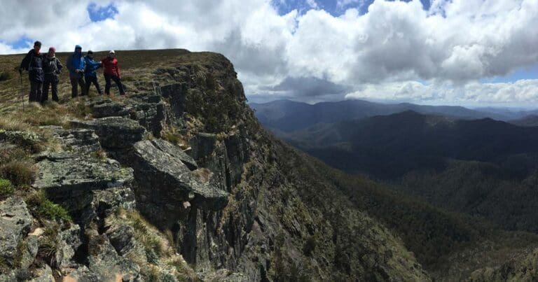
The Mount Clear Traverse is a 26-kilometre, grade 4 hike in Victoria's Alpine National Park, typically completed over two days. This challenging trek takes you through some of the region's most striking high country, including The Nobs, High Cone, and Mount Clear. It’s a full pack carry, meaning you'll need to bring along all your gear, food, and water for the journey.
The highlight of the hike is the summit of Mount Clear, a 1695-metre peak that stands out from many surrounding mountains. Its bald summit and commanding presence make it visible from various points in the area, offering an unbeatable vantage point of the alpine landscape. Along the way, you’ll also visit other notable peaks like The Nobs, at 1495 metres, with its twin summits, High Cone, which reaches 1488 metres and features a prominent point, and Square Top, at 1587 metres, known for its long, flat summit. Each of these peaks is straightforward to climb, requiring a steady ascent from the valley below.
Stage 1 (13.5km)
The first stage of the hike begins at the junction of Brocks Road and Clear Creek Road. From here, you’ll follow Clear Creek for about 2 kilometres before reaching the junction with Nobs Track and Mount Clear Spur Road. Turning right, you’ll continue along Nobs Track for roughly 4.7 kilometres, keeping an eye out for the Australian Alps Walking Track (AAWT) on your left. Following this track, you’ll ascend to the summit of The Nobs. The trail then veers east and continues for about 3 kilometres to the summit of High Cone. Just beyond the peak, the Grimme Creek Track junction appears, but you should stay on the AAWT as it descends from High Cone, crosses a broad saddle, and climbs up to an unnamed knoll. From here, the track skirts the north-western flanks of Square Top before reaching the summit of Mount Clear, about 1.5 kilometres away. This spot is a great place to camp for the night. It’s important to note, though, that there are no reliable water sources along the entire route, so you'll need to carry all your water or plan ahead to source it from elsewhere.
Stage 2 (12.5km)
On the second stage, you’ll head north from the summit of Mount Clear, again following the AAWT. After a little under 2 kilometres, you’ll reach the junction with the Mount Clear Track and Mount Clear Spur Road. Turn left here, heading west. From this point, the route gradually descends for the remainder of the hike. After approximately 9 kilometres, you’ll reach the junction with Clear Creek Road. Turn right and follow this road north-west for the final stretch back to the trailhead at Brocks Road, covering about 12.5 kilometres.
As mentioned earlier, there are no reliable water sources along the trail. Planning is essential, either by carrying enough water or researching potential collection points. For camping, the summit of Mount Clear makes a great overnight stop, or you might prefer the saddle to the north-west, which is near a possible water source. However, I can’t guarantee its reliability, as finding water here took a bit of searching.
This traverse is a rewarding and rugged adventure for those well-prepared, offering breathtaking views and a chance to immerse yourself in the heart of the Victorian Alps.
Tips
- There are no reliable water sources along the trail, so it's crucial to plan ahead. Make sure to carry enough water for the entire hike, or research potential water collection points along the route.
- The summit of Mount Clear is an ideal spot for an overnight camp, offering stunning views and a convenient location for the second day of the hike.
- Alternatively, you may consider camping at the saddle to the north-west of Mount Clear, which is close to a possible water source. However, this source is not guaranteed, as it took some effort to find, so be prepared for that uncertainty.
Content use
Please don’t copy GPX files or content from this site to AllTrails or other platforms. Each trail has been personally mapped, documented, and refined to support Australia’s bushwalking and hiking community. While some details come from land managers, every listing reflects significant personal effort. This is a free, community-driven initiative—your respect helps keep it that way.
Walk map and GPX file
Max elevation: 1693 m
Min elevation: 844 m
Total climbing: 1535 m
Total descent: -1535 m
Getting there
Getting to the trailhead: Alpine National Park.
To reach the trailhead, start from Mansfield and follow the Mount Buller Road for 20.5 kilometres, turning right at the Howqua Track turnoff, just 2 kilometres past the small town of Merrijig. Continue along the dirt Howqua Track for 16.5 kilometres until you reach the popular Sheepyard Flat, where you can camp on Friday night. From Sheepyard Flat, take Brocks Road, which is a rough dirt track suitable for 2WD vehicles.
After 19.5 kilometres, you’ll reach Eight Mile Gap; turn right here and descend into the Jamieson River Valley. Once in the valley, continue for approximately 3 kilometres to the Clear Creek Road turnoff on the right. Follow this side-road for 2.5 kilometres until you reach a 4WD track that joins the road on the right, 14 kilometres from Eight Mile Gap. You can leave your vehicles here, or drive a little further to park near the bridge over Clear Creek. This is also a good spot to fill any water containers before heading out on the hike.
Closest towns to this walk: Benalla, Bright, Dinner Plain, Falls Creek, Harrietville, Hotham Heights, Mansfield, Mitta Mitta, Mount Beauty, Mount Hotham, Myrtleford, Omeo, Porepunkah, Tawonga South, Wangaratta
About the region
The Alpine National Park is a national park in the Central Highlands and Alpine regions of Victoria, Australia. The 646,000-hectare national park is located northeast of Melbourne. It is the largest National Park in Victoria, and covers much of the higher areas of the Great Dividing Range in Victoria, including Victoria's highest point, Mount Bogong at 1,986 metres and the associated subalpine woodland and grassland of the Bogong High Plains. The park's north-eastern boundary is along the border with New South Wales, where it abuts the Kosciuszko National Park.
Similar walks nearby
Looking for more walks in or near Alpine National Park? Try these trails with a similar difficulty grade.
Track grade
Grade 4 (Hard) - Challenging Walks for Experienced Walkers: Grade 4 on the AWTGS signifies challenging walking tracks. Bushwalking experience is recommended for these tracks, which may be long, rough, and very steep. Directional signage may be limited, requiring a good sense of navigation. These walks are suited for experienced walkers who are comfortable with steeper inclines, rougher terrain, and potentially longer distances.
Explore safe
Plan ahead and hike safely! Carry enough water, pack layers for changing conditions, and bring safety gear like a torch, PLB, and reliable communication device. Check official sources for trail updates, closures, and access requirements, and review local weather and bushfire advice. Most importantly, share your plans with someone before you go. Being prepared makes for a safer and more enjoyable hike! Stay Safe, Explore More, and Always #ExploreSafe.
Packing checklists
What you carry in your pack depends on factors like weather, terrain, and your adventure type. Not sure what to bring? My free planning, food, and packing checklists are a great starting point, covering day hikes, overnight trips, and multi-day adventures. Use them to customise your kit and always prioritise safety.
Let someone know
Before heading out, take a moment to fill out your trip intentions form. It’s a quick way to share your hike details with family or friends. If something goes wrong, they can notify emergency services, ensuring a faster response and peace of mind. Stay safe and enjoy your adventure
Suggest an edit
Spotted a change on this trail? Maybe there are new features, the route has shifted, or the trail is permanently closed. Whatever the update, I’d love your input. Your feedback helps fellow hikers stay informed and ensures that our trail info stays fresh and reliable.
Acknowledgement of Country
Trail Hiking Australia acknowledges the Traditional Owners of the lands on which we hike and pay respects to their Elders, past and present, and we acknowledge the First Nations people of other communities who may be here today.
/Mount-Clear-Traverse-Hike_23.jpg)
/Mount-Clear-Traverse-Hike_25.jpg)
/Mount-Clear-Traverse-Hike_6.jpg)
/Mount-Clear-Traverse-Hike_17.jpg)
/Mount-Clear-Traverse-Hike_5.jpg)
/Mount-Clear-Traverse-Hike_24.jpg)
/Mount-Clear-Traverse-Hike_2.jpg)
/Mount-Clear-Traverse-Hike_40.jpg)
/Mount-Clear-Traverse-Hike_19.jpg)
/Mount-Clear-Traverse-Hike_20.jpg)
/Mount-Clear-Traverse-Hike_35.jpg)
/Mount-Clear-Traverse-Hike_31.jpg)
/Mount-Clear-Traverse-Hike_1.jpg)
/Mount-Clear-Traverse-Hike_34.jpg)
/Mount-Clear-Traverse-Hike_27.jpg)


8 Reviews on “Mount Clear Traverse Hike (26km)”
Sharing a review received from Tyrone B. Took advantage of the fine weather and decided to give this walk a go.
Headed off 4:30am from Melbourne wanting to get an early start taking in account the tedious drive from Merrijig to Clear creek trailhead.
Was met with some deer hunters as I was about to walk up the road, assured me I wouldn’t be shot I walked up the steep Nobs 4wd Track meeting up with the AAWT , was quite stuffed already hadn’t even started the real walking yet , made my way over The Nobs , then onto Highcone was windy up high not sure if I was hot or cold as the wind was cold and a blaring warm Spring sun. from Highcone thru to Mt Clear the GPS became my best friend, the track would appear and then disappear and would be left scrub bashing over and under fallen trees etc..
Was 3pm by the time I made it to the saddle between Square Top And Mt Clear and was pretty well buggered and tempted to setup camp and relax , but decided I wanted to get to the saddle on the other side of Mt Clear so I had an easy walk the next day back to the car , made camp by 5ish and was happy to be snug in bed after woofing down dinner.
Was a tough walk and I enjoyed very much with spectacular country views.
Alex Haigh let’s book this one in!
Kyle Schonie
Romana Hoffman
Stephen Carter Andrew Linehan
Completed this traverse on NYD 2022. The track from the Nob through to Square Top is completely overgrown and indistinguishable. It needs to be considered off track walking so make sure you are prepared for that type of navigation and allow plenty of time as it’s extremely slow going. While these track notes suggest water is available at the camp site we couldn’t find it even after an hour of searching. We were nearly out of water so made the call to continue on and walk out back to the car / creek. Took us 14 hrs all up.