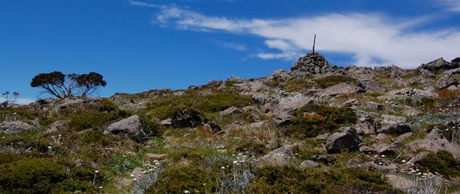
The Hotham to Dinner Plain Trail is a multi-purpose trail meanders through Snow Gum woodland and open snow plains, making it a very pleasant walk or cycle. Starting at either the Hotham General Store or Dinner Plain Village the trail is never far from the Great Alpine Road through the Alpine National Park.
Linking Dinner Plain to Hotham resort, the trail features panoramic views of the High Country. There are numerous areas to rest and picnic along the way. Starting from Dinner Plain Hut, follow Fitzy's Cirque west to the trail head at the boundary of the Alpine National Park. Return by the same route.
A side walk - 2km return - to Paw Paw Plain is a must for the fine views of the remote Dargo River Valley and Mount Tabletop.
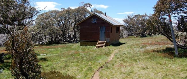
The trail provides an 1.8km easy walk to JB Hut, a cattlemen's post with remnants of yards built in the 19th century for catching wild horses. JB Plain was named after Jim Brown, who in the 1850s, brought cattle into the alpine region with partner, Jack Wells.
The present JB Hut was a forestry hut from the Swifts Creek forestry region and most likely came from a bush sawmill. It was moved to JB Plain in a joint effort between Cobungra Station and the Bairnsdale Scout Group in the 1970s. It was used as an outstation by Cobungra Station during mustering season well into the 1980s.
Got some great shots from this hike? Upload your photos here to inspire others and show off the beauty of the trail!
Submitting your photos doesn’t mean you lose ownership. You can be credited for your contributions, and you can request removal at any time.
Please don’t copy GPX files or content from this site to AllTrails or other platforms. Each trail has been personally mapped, documented, and refined to support Australia’s bushwalking and hiking community. While some details come from land managers, every listing reflects significant personal effort. This is a free, community-driven initiative—your respect helps keep it that way.
Total distance: 11188 m
Max elevation: 1716 m
Min elevation: 1584 m
Total climbing: 236 m
Total descent: -368 m
Getting there
Getting to the trailhead: Alpine National Park.
Option 1. Take the Hume Hwy to Wangaratta then the Great Alpine Road direct to Hotham, or the Snow Road via Milawa & Oxley to Myrtleford, Bright, Harrietville & Hotham. Travel time around 4.25 hours with a distance of 380km..
Option 2. Take the Monash Freeway (which turns into the Princes Hwy) to Bairnsdale, then Omeo, then the Great Alpine Road to Hotham past the Hotham Airport and Dinner Plain. Travel time around 5.5 hours with a distance of 460km.
Check out the Winter Access Guide for straightforward advice on driving in the snow, resort entry processes, parking and more.
Closest towns to this walk: Benalla, Bright, Dinner Plain, Falls Creek, Harrietville, Hotham Heights, Mansfield, Mitta Mitta, Mount Beauty, Mount Hotham, Myrtleford, Omeo, Porepunkah, Tawonga South, Wangaratta
About the region
The Alpine National Park is a vast national park encompassing 646,000 hectares in the Central Highlands and Alpine regions of Victoria, Australia. Situated northeast of Melbourne, it reigns as the largest national park in Victoria, safeguarding a significant portion of the Great Dividing Range's highest elevations. Mount Bogong, Victoria's highest peak at 1,986 meters, stands majestically within the park's boundaries, along with the surrounding subalpine woodlands and grasslands of the Bogong High Plains. The park's northeastern edge aligns with the New South Wales border, where it seamlessly transitions into the Kosciuszko National Park.
Similar walks nearby
Looking for more walks in or near Alpine National Park? Try these trails with a similar difficulty grade.
Favourite

Favourite

Favourite

Favourite

Track grade
Grade 3 (Moderate) - Walks for Most Fitness Levels: Grade 3 on the
AWTGS represents moderate walking tracks. These are ideal for walkers with some fitness who are comfortable with some hills and uneven terrain. While suitable for most ages, some bushwalking experience is recommended to ensure a safe and enjoyable experience. Tracks may have short, steep hill sections, a rough surface, and many steps. The total distance of a Grade 3 walk can be up to 20 kilometers.
Explore safe
Plan ahead and hike safely! Carry enough water, pack layers for changing conditions, and bring safety gear like a torch, PLB, and reliable communication device. Check official sources for trail updates, closures, and access requirements, and review local weather and bushfire advice. Most importantly, share your plans with someone before you go. Being prepared makes for a safer and more enjoyable hike! Stay Safe, Explore More, and Always #ExploreSafe.
Packing checklists
What you carry in your pack depends on factors like weather, terrain, and your adventure type. Not sure what to bring? My free planning, food, and packing checklists are a great starting point, covering day hikes, overnight trips, and multi-day adventures. Use them to customise your kit and always prioritise safety.
Let someone know
Before heading out, take a moment to fill out your trip intentions form. It’s a quick way to share your hike details with family or friends. If something goes wrong, they can notify emergency services, ensuring a faster response and peace of mind. Stay safe and enjoy your adventure
Suggest an edit
Spotted a change on this trail? Maybe there are new features, the route has shifted, or the trail is permanently closed. Whatever the update, I’d love your input. Your feedback helps fellow hikers stay informed and ensures that our trail info stays fresh and reliable.


