Hike at a Glance
Max elevation: 519m
Min elevation: 453m
Total Ascent: 99m
Hike overview
The Booloumba Falls Walk in Conondale National Park is a 3-kilometre return track that winds through towering eucalypt forest, leading to a series of cascades, waterfalls, and rock pools. Set within the rugged Conondale Range, this grade 3 hike typically takes around 1.5 hours to complete, offering a rewarding journey through one of Queensland’s most stunning natural landscapes.
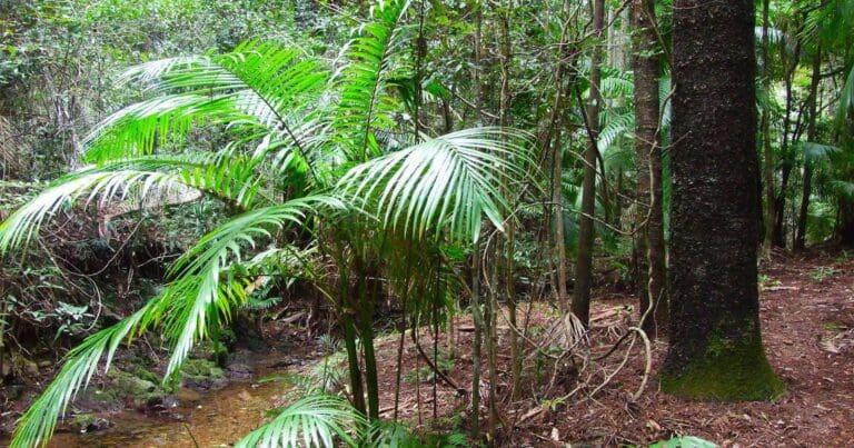
The trail meanders through open forest before descending towards the clear waters of Booloumba Creek. Sunlight filters through the canopy, illuminating ferns and moss-covered rocks along the way. The sound of flowing water grows louder as you approach the falls, where the creek tumbles over smooth rock ledges into inviting pools below. At the junction of Peters Creek and Booloumba Creek, The Breadknife, an imposing blade-like rock formation, rises from the water—a striking geological feature shaped over millennia by the relentless flow of these ancient waterways.
Conondale National Park is a place of remarkable biodiversity, and this walk offers glimpses of the park’s thriving ecosystem. Keep an eye out for goannas basking on warm rocks, vibrant kingfishers darting through the trees, and the occasional flash of a Richmond birdwing butterfly. The calls of whipbirds and the rustling of unseen creatures in the undergrowth add to the sense of immersion in this wild and remote landscape.
Beyond the falls, the Conondale Range stretches in all directions, with deep gorges, rainforest-clad slopes, and boulder-strewn creeks shaping the terrain. This park protects some of Queensland’s most pristine environments, where ancient rainforests give way to tall eucalypt forests, and crystal-clear streams carve their way through rocky gullies. Every step on the trail reveals a new perspective on this diverse and ever-changing landscape.
Booloumba Falls is an ideal spot to pause and take in the surroundings. Whether you choose to dip your feet in the cool water, explore the rock pools, or simply sit and appreciate the solitude, it’s a place that invites you to slow down and connect with nature. The return walk retraces the same path, allowing for a second look at the intricate details that make this part of the national park so special.
Gallery
Got some great shots from this hike? Upload your photos here to inspire others and show off the beauty of the trail!
Click to view form >>
Submitting your photos doesn’t mean you lose ownership. You can be credited for your contributions, and you can request removal at any time.
Content use
Please don’t copy GPX files or content from this site to AllTrails or other platforms. Each trail has been personally mapped, documented, and refined to support Australia’s bushwalking and hiking community. While some details come from land managers, every listing reflects significant personal effort. This is a free, community-driven initiative—your respect helps keep it that way.
Walk map and GPX file
Max elevation: 519 m
Min elevation: 453 m
Total climbing: 99 m
Total descent: -99 m
Getting there
Getting to the trailhead: Conondale National Park.
To reach the Booloumba Falls car park in Conondale National Park from Brisbane, head north on the Bruce Highway and take the Kenilworth exit. Follow Eumundi-Kenilworth Road for about 28 kilometres, passing through the township of Kenilworth. Continue toward Maleny for another 7 kilometres before turning right onto Booloumba Creek Road, just after Little Yabba Creek Park. From here, the road becomes unsealed, and you’ll need to follow it for another 5 kilometres to reach the park entrance.
A high-clearance four-wheel-drive vehicle is essential for access, as the road includes several natural creek crossings. Conditions can vary depending on recent rainfall, and heavy downpours can make the crossings impassable. Always check current park alerts and weather forecasts before setting out, and if you encounter flooded creeks, it’s safest to turn back and wait it out.
If you’re coming from Maleny, take the Maleny-Kenilworth Road west for about 30 kilometres, passing through the small town of Conondale. The turn-off to Booloumba Creek Road is roughly 13 kilometres past Conondale. Follow the same unsealed track to the park entrance, keeping in mind that road conditions can change with the weather.
For those seeking a more accessible alternative, the Charlie Moreland camping area in Imbil State Forest offers a similar bush setting and is suitable for two-wheel-drive vehicles. It can be reached via Kenilworth or Conondale, providing a good backup option if conditions at Booloumba Creek are too challenging.
Closest towns to this walk: Conondale, Curramore, Flaxton, Kenilworth, Maleny, Mapleton, Montville, Nambour, Witta
About the region
About 130 kilometres north of Brisbane, Conondale National Park stretches across 35,648 hectares in the Sunshine Coast Hinterland, protecting a diverse landscape of subtropical rainforest, woodlands, and sclerophyll forests. It is home to Queensland’s tallest tree and features pockets of regenerating forest, remnants of past logging operations. Bordering the park, former plantation areas hint at the region’s history of timber harvesting. Now managed under the Nature Conservation Act 1992, the park serves as a refuge for rare and threatened species while offering a rugged and unspoiled wilderness for those who seek to explore its remote trails and waterways.
The Conondale region has seen significant environmental change since the 1860s, with land clearing for agriculture, mining, and logging shaping much of the terrain. Despite these impacts, the park remains a sanctuary for a variety of species, including the plumed frogmouth, giant barred frog, Conondale crayfish, spotted-tailed quoll, Gympie nut, and Richmond birdwing butterfly. Conservation efforts focus on mitigating threats to their survival, ensuring these species continue to inhabit the area. Of particular historical interest is the southern gastric-brooding frog, which was once recorded in the park before mysteriously disappearing in 1981. Presumed extinct, its loss remains one of the more intriguing mysteries in Australian wildlife conservation.
The park’s rugged topography is defined by deep gorges, steep valleys, and peaks that rise above 700 metres, with Mount Langley standing as the highest at 868 metres. Numerous waterfalls, cascades, and boulder-strewn creeks weave through the landscape, providing vital water sources for local wildlife. Booloumba Creek Falls is among the park’s most striking natural features, offering a glimpse into the power and beauty of the waterways that have carved through the range over time. The Conondale Range forms a natural divide between the Brisbane and Mary River catchments, with the park’s southernmost tributaries feeding into Booloumba and Yabba creeks. These waterways play an important role in sustaining the critically endangered Mary River cod, a species that has seen significant decline in recent decades.
With an annual rainfall of around 1,500 millimetres, Conondale National Park experiences distinct seasonal variations. Heavy summer downpours between December and March bring lush growth and increased creek flows, while winters tend to be cool and dry, with occasional frosts settling across the higher elevations. The park’s vegetation is equally diverse, ranging from dense notophyll vine forests and subtropical rainforest to stands of Bangalow palms, wet and dry sclerophyll forests, and expansive woodlands. Rainforest is most commonly found at higher altitudes and along the waterways, creating a shifting mosaic of habitats that support an incredible variety of plant and animal life.
This rich natural landscape tells a story of resilience, change, and ongoing conservation efforts. Whether exploring its remote trails, pausing by a secluded waterfall, or simply taking in the dense, layered greenery of its forests, Conondale National Park offers a glimpse into a wild and ancient world that continues to evolve with each passing season.
Similar walks nearby
Looking for more walks in or near Conondale National Park? Try these trails with a similar difficulty grade.
Track grade
Grade 3 (Moderate) - Walks for Most Fitness Levels: Grade 3 on the AWTGS represents moderate walking tracks. These are ideal for walkers with some fitness who are comfortable with some hills and uneven terrain. While suitable for most ages, some bushwalking experience is recommended to ensure a safe and enjoyable experience. Tracks may have short, steep hill sections, a rough surface, and many steps. The total distance of a Grade 3 walk can be up to 20 kilometers.
Explore safe
Plan ahead and hike safely! Carry enough water, pack layers for changing conditions, and bring safety gear like a torch, PLB, and reliable communication device. Check official sources for trail updates, closures, and access requirements, and review local weather and bushfire advice. Most importantly, share your plans with someone before you go. Being prepared makes for a safer and more enjoyable hike! Stay Safe, Explore More, and Always #ExploreSafe.
Packing checklists
What you carry in your pack depends on factors like weather, terrain, and your adventure type. Not sure what to bring? My free planning, food, and packing checklists are a great starting point, covering day hikes, overnight trips, and multi-day adventures. Use them to customise your kit and always prioritise safety.
Let someone know
Before heading out, take a moment to fill out your trip intentions form. It’s a quick way to share your hike details with family or friends. If something goes wrong, they can notify emergency services, ensuring a faster response and peace of mind. Stay safe and enjoy your adventure
Suggest an edit
Spotted a change on this trail? Maybe there are new features, the route has shifted, or the trail is permanently closed. Whatever the update, I’d love your input. Your feedback helps fellow hikers stay informed and ensures that our trail info stays fresh and reliable.
Acknowledgement of Country
Trail Hiking Australia acknowledges the Traditional Owners of the lands on which we hike and pay respects to their Elders, past and present, and we acknowledge the First Nations people of other communities who may be here today.


