Hike at a Glance
Max elevation: 0m
Min elevation: 0m
Total Ascent: 0m
Important info
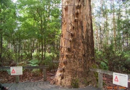
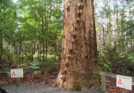
Note that climbing the tree can be dangerous, please note the warnings displayed at the base.
Hike overview
To give a flavour of the Bibbulmun Track we describe a 6 km section near Pemberton in south west Western Australia, of which about half is on railway formation. The return walk is 12 km. The walk features the Gloucester Fire Tree and a series of waterfalls. There is also a tourist railway nearby.
The Bibbulmun Track is Australia's major long distance walking track. It runs from Kalamunda, near Perth to Albany, a distance of 956 km. Like the Munda Biddi long distance cycling trail, sections of the Bibbulmun follow old tramway formations. (Tramways are lightly built railways, mainly used for industrial use such as for logging or mining.) However, in the case of the Bibbulmun, many of the tramway sections are quite short.
This walk starts 3 km south of Pemberton at the Gloucester Fire Tree in Gloucester National Park. The Gloucester Tree is a 60 metre karri tree with pegs hammered into its trunk to form a spiral ladder to a platform at the top. It was originally among eight trees in the area pegged to allow fire spotters to climb and scan the surrounding area for bushfires. Today it is popular with tourists who can climb to the top. Car parking and picnic facilities are available here.
From the tree, follow the Bibbulmun Track markers south east to Burma Road. After crossing East Brook, the track turns right and joins the route of a tramway which ran beside the brook, recognisable by its well-formed shape. After about 3 km, the Bibbulmun turns to the left. If you continue along the tramway a short way you can view a railway bridge, where the existing railway runs over the top, and the tramway formation passes underneath.
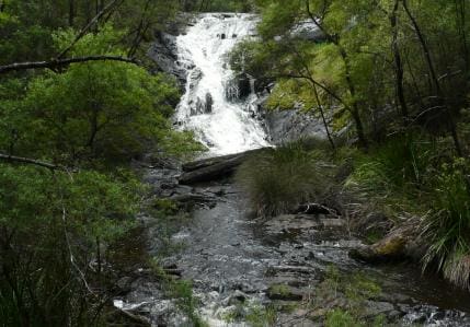
Continuing along the Bibbulmun, you will come to a turnoff to the Cascades. The Cascades are a series of small waterfalls. A loop trail allows you to walk right around them and connects with the Cascades car park and picnic area.
Return by the same route. Alternatively, catch the tourist train from Pemberton one way to the Cascades and walk back along the Bibbulmun (9 km walk). For a longer walk, continue on the train to Gloucester Road (12 km walk).
The Bibbulmun picks up tramway formations in the area twice more as it heads south. At the Warren River, it crosses the river on a long timber trestle bridge. You can reach this bridge by car using dirt roads as shown on the map.
For more information on the Bibbulmun track, see the Bibbulmun Track guide books (see link below).
Details of rail trail manager: Bibbulmun Track: http://www.bibbulmuntrack.org.au/
Gloucester National Park http://www.dec.wa.gov.au/component/option,com_hotproperty/task,view/id,88/Itemid,755/
Pemberton Tramway (Tourist Railway) http://www.pemtram.com.au/Pemberton Tramway Company.htm
Tips
Gloucester Tree to Cascades in Regional Western Australia
South of Pemberton, 340 km from Perth
Compacted earth
Photo credit: Rail Trails Australia. For more information and a location map please visit RailTrails Australia.
Track grade
Grade 3 (Moderate) - Walks for Most Fitness Levels: Grade 3 on the AWTGS represents moderate walking tracks. These are ideal for walkers with some fitness who are comfortable with some hills and uneven terrain. While suitable for most ages, some bushwalking experience is recommended to ensure a safe and enjoyable experience. Tracks may have short, steep hill sections, a rough surface, and many steps. The total distance of a Grade 3 walk can be up to 20 kilometers.
Walk map and GPX file
Do you have a GPX file for this hike? Feel free to email it to me so I can add it to this hikes info.
Click to add your file >>
Content use
Please don’t copy GPX files or content from this site to AllTrails or other platforms. Each trail has been personally mapped, documented, and refined to support Australia’s bushwalking and hiking community. While some details come from land managers, every listing reflects significant personal effort. This is a free, community-driven initiative—your respect helps keep it that way.
Gallery
Got any photos from this hike? Your photos can help others plan. Share shots from along the trail so fellow hikers know what to expect.
Click to add your photos >>
Getting there
Getting to the trailhead: Regional Western Australia.
Need a rental car to get you to the hike? Find one here.
About the region
A Wander out Yonder in WA will make you feel like you've truly reset, reconnected and had a real holiday. WA is full of adventures waiting to be discovered. Travel further, stay for longer and explore the wonders only WA can offer. Share the water with wild dolphins, or see the gorges of Kalbarri from a new perspective in WA there's more in store than you could ever see.
Find a place to stay
Wondering where to stay near this hike? Find accommodation close to the trailhead — hotels, cabins and campgrounds nearby. Click the button to view the interactive map.
Closest towns to this walk: Albany, Broome, Bunbury, Carnarvon, Denmark, Esperance, Geraldton, Kalgoolie, Kalgoorlie, Karratha, Kununurra, Leonora, Manjimup, Merredin, Mount Barker, Narrogin, Newman, Port Hedland
Let someone know
Heading out? Fill in a trip intentions form so someone knows your plans. If things go wrong, they can raise the alarm fast, giving you peace of mind on the trail.
Similar walks nearby
Looking for more walks in or near Regional Western Australia? Try these trails with a similar difficulty grade.
Suggest an edit
Notice something different about this trail? Whether it’s a new feature, a route change, or a closure, share your update so we can keep our info accurate and helpful for fellow hikers.
Click to suggest edits >>
Explore safe
Plan ahead and hike safely! Carry enough water, pack layers for changing conditions, and bring safety gear like a torch, PLB, and reliable communication device. Check official sources for trail updates, closures, and access requirements, and review local weather and bushfire advice. Most importantly, share your plans with someone before you go. Being prepared makes for a safer and more enjoyable hike! Stay Safe, Explore More, and Always #ExploreSafe.
Packing checklists
What you carry in your pack depends on factors like weather, terrain, and your adventure type. Not sure what to bring? My free planning, food, and packing checklists are a great starting point, covering day hikes, overnight trips, and multi-day adventures. Use them to customise your kit and always prioritise safety.
Acknowledgement of Country
Trail Hiking Australia acknowledges the Traditional Owners of the lands on which we hike and pay respects to their Elders, past and present, and we acknowledge the First Nations people of other communities who may be here today.


