Hike at a Glance
Max elevation: 322m
Min elevation: 242m
Total Ascent: 104m
Hike overview
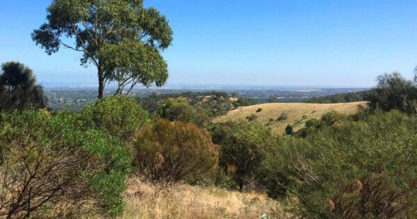
Experience the panoramic views of Para Wirra Conservation Park with the Devils Nose Hike, a moderately challenging (grade 4) 5-kilometer journey. This out-and-back trail, estimated to take approximately 2 hours to complete, commences at the Para Wirra Drive Carpark.
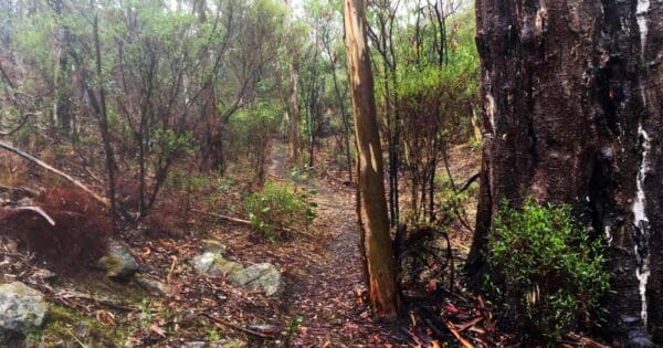
The initial section eases you in with a gentle fire track, gradually transitioning into a dedicated walking trail. Be prepared for some rocky sections along this path as you ascend towards the namesake lookout point – Devils Nose. Upon reaching your destination, be rewarded with breathtaking views that stretch along the ridge, offering a glimpse into the surrounding bushland. To conclude your adventure, simply retrace your steps and return to the starting point.
Track grade
Grade 4 (Hard) - Challenging Walks for Experienced Walkers: Grade 4 on the AWTGS signifies challenging walking tracks. Bushwalking experience is recommended for these tracks, which may be long, rough, and very steep. Directional signage may be limited, requiring a good sense of navigation. These walks are suited for experienced walkers who are comfortable with steeper inclines, rougher terrain, and potentially longer distances.
Walk map and GPX file
Max elevation: 322 m
Min elevation: 242 m
Total climbing: 104 m
Total descent: -104 m
Content use
Please don’t copy GPX files or content from this site to AllTrails or other platforms. Each trail has been personally mapped, documented, and refined to support Australia’s bushwalking and hiking community. While some details come from land managers, every listing reflects significant personal effort. This is a free, community-driven initiative—your respect helps keep it that way.
Gallery
Got any photos from this hike? Your photos can help others plan. Share shots from along the trail so fellow hikers know what to expect.
Click to add your photos >>
Getting there
Getting to the trailhead: Para Wirra Conservation Park.
Para Wirra Conservation Park is conveniently located 41 kilometers north of Adelaide. The park boasts multiple entry points, with the main entrance accessible through the Western Gate off Humbug Scrub Road. Campers arriving after park hours can use the Eastern Gate, also located off Humbug Scrub Road. However, this gate requires a unique combination lock code provided during campground reservation and remains locked to general visitors. Please note that the Western Gate operates on sunrise to sunset hours, with the exception of Christmas Day.
Need a rental car to get you to the hike? Find one here.
Find a place to stay
Wondering where to stay near this hike? Find accommodation close to the trailhead — hotels, cabins and campgrounds nearby. Click the button to view the interactive map.
Closest towns to this walk: Birdwood, Elizabeth, Gawler, Golden Grove, Gumeracha, Inglewood, Kersbrook, Lobethal, Lynton, Millbrook, Modbury, Mount Pleasant, Mt Pleasant, One Tree Hill, Para Wirra, Salisbury, Tea Tree Gully, Williamstown
Let someone know
Heading out? Fill in a trip intentions form so someone knows your plans. If things go wrong, they can raise the alarm fast, giving you peace of mind on the trail.
About the region
Nestled in the foothills of the rugged Mount Lofty Ranges, Para Wirra Conservation Park holds significance for three Aboriginal nations: the Kaurna, Peramangk, and Ngadjuri. The park's name itself reflects this heritage, with "Para" (or Kaurna "Pari") translating to "river, creek, or gully" and "Wirra" meaning "forest." This aptly describes the park's landscape, where the ranges meet the Barossa Valley and mallee plains, creating a natural gathering point for these indigenous groups.
National Parks are actively collaborating with these nations to develop and share cultural interpretations of the park. Visitors can immerse themselves in the natural beauty of Para Wirra, with opportunities for hiking, picnicking, and observing native wildlife. Over 100 bird species call the park home, including emus that may even visit the picnic grounds. Kangaroos graze at dawn and dusk, while reptiles like bearded dragons and sleepy lizards soak up the sun on warm days. Keen observers might even spot the shy short-beaked echidna, evidenced by its characteristic diggings throughout the park.
Para Wirra caters perfectly to families and groups. Accessible facilities are nestled within the natural bush setting, with a lake serving as a popular attraction. Barbecue areas and picnic tables offer scenic views over the water, where the surrounding bushland creates a mirror-like reflection on calm days.
Similar walks nearby
Looking for more walks in or near Para Wirra Conservation Park? Try these trails with a similar difficulty grade.
Explore safe
Plan ahead and hike safely! Carry enough water, pack layers for changing conditions, and bring safety gear like a torch, PLB, and reliable communication device. Check official sources for trail updates, closures, and access requirements, and review local weather and bushfire advice. Most importantly, share your plans with someone before you go. Being prepared makes for a safer and more enjoyable hike! Stay Safe, Explore More, and Always #ExploreSafe.
Packing checklists
What you carry in your pack depends on factors like weather, terrain, and your adventure type. Not sure what to bring? My free planning, food, and packing checklists are a great starting point, covering day hikes, overnight trips, and multi-day adventures. Use them to customise your kit and always prioritise safety.
Suggest an edit
Notice something different about this trail? Whether it’s a new feature, a route change, or a closure, share your update so we can keep our info accurate and helpful for fellow hikers.
Click to suggest edits >>
Acknowledgement of Country
Trail Hiking Australia acknowledges the Traditional Owners of the lands on which we hike and pay respects to their Elders, past and present, and we acknowledge the First Nations people of other communities who may be here today.


