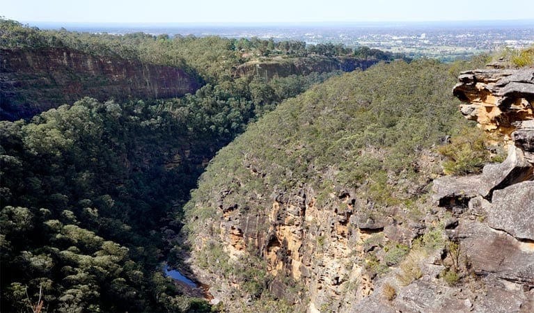
Take in delightful views on the Caleys lookout track in Bents Basin State Conservation Area, not far from Penrith. Named after English explorer and botanist, George Caley, the lookout track follows a shady path from the Bents Basin Road picnic area up into the forested escarpment. Children might find it a bit steep, although you're assisted by stone, wooden and metal steps along the way.
At the end of the walk is Caleys lookout in the neighbouring Gulguer Nature Reserve. There are picnic tables at the fenced lookout, so you can bring along a picnic lunch to tuck into while you enjoy expansive views over the tall eucalypts above Bents Basin.
You can also look across to Bents Basin campground, taking in the view of pretty patchwork farmland and rugged bushland of western Sydney. There are picnic tables at the lookout, so you can bring along a picnic lunch to tuck into while you're admiring the view.
Remember to wear suitable walking shoes, as this track is quite steep
Please note that park gates lock automatically after hours
Visit NSW National Parks and Wildlife Service for more information on this trail.
The longitude and latitude of the start and end points are approximately only and should not be used for navigation purposes. Please contact me if you know the correct coordinates.
Got some great shots from this hike? Upload your photos here to inspire others and show off the beauty of the trail!
Submitting your photos doesn’t mean you lose ownership. You can be credited for your contributions, and you can request removal at any time.
Please don’t copy GPX files or content from this site to AllTrails or other platforms. Each trail has been personally mapped, documented, and refined to support Australia’s bushwalking and hiking community. While some details come from land managers, every listing reflects significant personal effort. This is a free, community-driven initiative—your respect helps keep it that way.
It looks like I don’t have a GPX file for this trail yet. If you have one to share, please email it to me! I’ll verify it against official maps before adding it to help other hikers have a safer, easier experience. Thanks for contributing to a better hiking resource.
Getting there
Getting to the trailhead: Bents Basin State Conservation Area.
Caleys lookout track starts at Bents Basin Road picnic area in the northern precinct of Bents Basin State Conservation Area. To get there:From Wallacia, follow Silverdale Road westTurn left onto Bents Basin Road and continue to the endAt Bents Basin Road picnic area the trackhead is located to the west of the carpark.Bents Basin Road picnic area is also accessible by foot from southern precinct of the park by taking the footpath across the short bridge next to the water. Parking Parking is available at Bents Basin Road picnic area
Closest towns to this walk: Badgerys Creek, Luddenham, Silverdale, Wallacia, Wellington
About the region
Bents Basin State Conservation Area in the Sydney and surrounds region
The park gates open at 9am all year round and close at 4.30pm (May to Sept) and 7pm (Oct to Apr).
Similar walks nearby
Looking for more walks in or near Bents Basin State Conservation Area? Try these trails with a similar difficulty grade.
Favourite

Blue Mountains National Park
Favourite

Blue Mountains National Park
Favourite

Blue Mountains National Park
Favourite

Blue Mountains National Park
Track grade
Grade 4 (Hard) -
Challenging Walks for Experienced Walkers: Grade 4 on the
AWTGS signifies challenging walking tracks. Bushwalking experience is recommended for these tracks, which may be long, rough, and very steep. Directional signage may be limited, requiring a good sense of navigation. These walks are suited for experienced walkers who are comfortable with steeper inclines, rougher terrain, and potentially longer distances.
Explore safe
Plan ahead and hike safely! Carry enough water, pack layers for changing conditions, and bring safety gear like a torch, PLB, and reliable communication device. Check official sources for trail updates, closures, and access requirements, and review local weather and bushfire advice. Most importantly, share your plans with someone before you go. Being prepared makes for a safer and more enjoyable hike! Stay Safe, Explore More, and Always #ExploreSafe.
Packing checklists
What you carry in your pack depends on factors like weather, terrain, and your adventure type. Not sure what to bring? My free planning, food, and packing checklists are a great starting point, covering day hikes, overnight trips, and multi-day adventures. Use them to customise your kit and always prioritise safety.
Let someone know
Before heading out, take a moment to fill out your trip intentions form. It’s a quick way to share your hike details with family or friends. If something goes wrong, they can notify emergency services, ensuring a faster response and peace of mind. Stay safe and enjoy your adventure
Suggest an edit
Spotted a change on this trail? Maybe there are new features, the route has shifted, or the trail is permanently closed. Whatever the update, I’d love your input. Your feedback helps fellow hikers stay informed and ensures that our trail info stays fresh and reliable.


