Hike at a Glance
Max elevation: 576m
Min elevation: 449m
Total Ascent: 536m
Hike overview
Byers Back Track is a 12.5-kilometre walk through a striking section of Lerderderg State Park in Victoria, stretching between the historic town of Blackwood and the popular picnic and camping area at O’Brien’s Crossing. It typically takes around three hours to complete in one direction, though the time may vary depending on track conditions and pace. While some hikers choose to tackle the route as a return trip, retracing their steps, others opt for a car shuffle or continue along Tunnel Point Track to form a circuit known locally as the Blackwood Hike Circuit.
The trail mostly follows the course of old water races, remnants of the area’s gold rush past. These narrow channels were once carved into the hillsides to direct water from nearby dams and rivers down to alluvial gold workings. Because the races were built to carry water by gravity, they tend to follow the natural contours of the land, creating long stretches of relatively flat terrain that wind their way across the slopes. This makes for a comfortable walking gradient, though it doesn’t mean the track is without its challenges.
Underfoot, the path can be rough and uneven, especially where erosion, tree roots, fallen branches, or loose rocks break up the surface. There are a few sections where the track skirts steep drop-offs or crosses narrow footbridges and stairways. After rain, these areas can become slippery, so care is needed. Still, for those with moderate bushwalking experience, it’s a track that offers a good balance between accessibility and interest, with just enough roughness to keep things engaging.
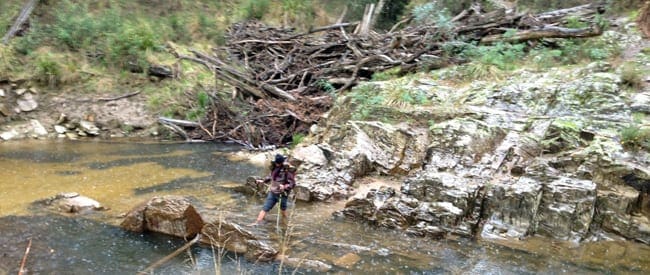
The surrounding landscape shifts subtly as you walk. Much of the trail is framed by tall eucalypts, the dry, open forest providing dappled light and the scent of gum leaves. In steeper parts of the gorge, the vegetation becomes denser and more varied, revealing glimpses of the Lerderderg River far below. These elevated sections offer a real sense of the scale and beauty of the terrain. Along the way, you’ll also pass old mine shafts and diggings—reminders of the intense prospecting that once transformed this landscape.
Byers Back Track is one of those walks that invites you to slow down, pay attention, and notice the layers of history and ecology etched into the bush. Whether you’re looking for a peaceful day walk or a more immersive journey through Lerderderg’s rugged heart, this track provides both practical access and a strong sense of place.
Content use
Please don’t copy GPX files or content from this site to AllTrails or other platforms. Each trail has been personally mapped, documented, and refined to support Australia’s bushwalking and hiking community. While some details come from land managers, every listing reflects significant personal effort. This is a free, community-driven initiative—your respect helps keep it that way.
Walk map and GPX file
Max elevation: 576 m
Min elevation: 449 m
Total climbing: 536 m
Total descent: -474 m
Getting there
Getting to the trailhead: Lerderderg State Park.
O’Briens Crossing is in the centre of the northern section of the park, along O’Briens Road. The crossing is located approximately 4km from the Greendale-Blackwood Road, with the turnoff approximately a 5km drive north of Greendale. The track into the crossing is quite good with sufficient access for 2WD’s and caravans.
Closest towns to this walk: Bacchus Marsh, Ballan, Blackwood, Bullengarook, Coimadai, Darley, Daylesford, Gisborne, Kyneton, Macarthur, Macedon, Maddingley, Melton, Myrniong, Sunbury, Trentham, Woodend
Access conditions
- 4WD Access
- Public Transport
- Gravel Road
- Speed Bumps
- Accessible Toilet
- Public Toilets
- Untreated Water
- Picnic Shelter
About the region
Rising in the Great Dividing Range, the Lerderderg River has cut a 300 metre deep gorge through sandstone and slate, almost bisecting the park. The park has a wide variety of vegetation and wildlife and some interesting relics of gold mining. Lerderderg State Park encompasses scenic and geological gorge formations surrounding the Lerderderg River as well as the volcanic cone of Mount Blackwood. The adjacent and separate block called the Pyrete Range forms part of the park. The Lerderderg is known for its remote setting and the 300m deep Lerderderg River gorge is a dominant feature. Private land abuts the park to the south and the Wombat State forest abuts to the north and west.
Lerderderg State Park (incorporating the former Pyrete State Forest) is a 14,250-hectare park located between Bacchus Marsh and Blackwood, an hour's drive from Melbourne, Australia. There are several maintained tracks for walking through the park and camping is allowed.
The park is named for the Lerderderg River which has cut the 300 metre deep Lerderderg Gorge through sandstone and slate, almost bisecting the park. Parks Victoria maintains six designated walks: three short walks of 3.5 km or less; Blackwood-O'Briens Crossing and return (22 km); O'Briens Crossing-Cowan Track loop (14 km); and the overnight walk O'Briens Crossing to Mackenzies Flat (20 km).
In addition, one leg of the Great Dividing Trail, the Lerderderg Track, passes through the park, entering from Blackwood in the park's northwest, and exiting south towards Bacchus Marsh. Bicycles are prohibited from one section of this track, due to a conservation area.
Similar walks nearby
Looking for more walks in or near Lerderderg State Park? Try these trails with a similar difficulty grade.
Track grade
Grade 3 (Moderate) - Walks for Most Fitness Levels: Grade 3 on the AWTGS represents moderate walking tracks. These are ideal for walkers with some fitness who are comfortable with some hills and uneven terrain. While suitable for most ages, some bushwalking experience is recommended to ensure a safe and enjoyable experience. Tracks may have short, steep hill sections, a rough surface, and many steps. The total distance of a Grade 3 walk can be up to 20 kilometers.
Explore safe
Plan ahead and hike safely! Carry enough water, pack layers for changing conditions, and bring safety gear like a torch, PLB, and reliable communication device. Check official sources for trail updates, closures, and access requirements, and review local weather and bushfire advice. Most importantly, share your plans with someone before you go. Being prepared makes for a safer and more enjoyable hike! Stay Safe, Explore More, and Always #ExploreSafe.
Packing checklists
What you carry in your pack depends on factors like weather, terrain, and your adventure type. Not sure what to bring? My free planning, food, and packing checklists are a great starting point, covering day hikes, overnight trips, and multi-day adventures. Use them to customise your kit and always prioritise safety.
Let someone know
Before heading out, take a moment to fill out your trip intentions form. It’s a quick way to share your hike details with family or friends. If something goes wrong, they can notify emergency services, ensuring a faster response and peace of mind. Stay safe and enjoy your adventure
Suggest an edit
Spotted a change on this trail? Maybe there are new features, the route has shifted, or the trail is permanently closed. Whatever the update, I’d love your input. Your feedback helps fellow hikers stay informed and ensures that our trail info stays fresh and reliable.
Acknowledgement of Country
Trail Hiking Australia acknowledges the Traditional Owners of the lands on which we hike and pay respects to their Elders, past and present, and we acknowledge the First Nations people of other communities who may be here today.
/Byers-Back-Track%20%20(10).jpg)
/Byers-Back-Track%20%20(13).jpg)
/Byers-Back-Track%20%20(17).jpg)
/Byers-Back-Track%20%20(16).jpg)
/Byers-Back-Track_4.jpg)
/Byers-Back-Track_14.jpg)
/Byers-Back-Track_5.jpg)
/Byers-Back-Track_9.jpg)
/Byers-Back-Track%20%20(19).jpg)
/Byers-Back-Track%20%20(6).jpg)
/Byers-Back-Track%20%20(25).jpg)
/Byers-Back-Track%20%20(31).jpg)
/Byers-Back-Track_1.jpg)
/Byers-Back-Track%20%20(29).jpg)
/Byers-Back-Track%20%20(11).jpg)


