Hike at a Glance
Max elevation: 267m
Min elevation: 162m
Total Ascent: 313m
Hike overview
The Beards Gully and Deadman’s Loop is a challenging 9.5-kilometre hike through the Brisbane Ranges National Park, located south-west of the historic Steiglitz. This grade 4 walk follows the course of Sutherland Creek, offering glimpses into the region’s gold mining history. The hike typically takes around four hours to complete.
Be prepared for rugged terrain, including steep ascents and descents. The presence of old mine shafts poses a significant risk, requiring caution throughout the walk.
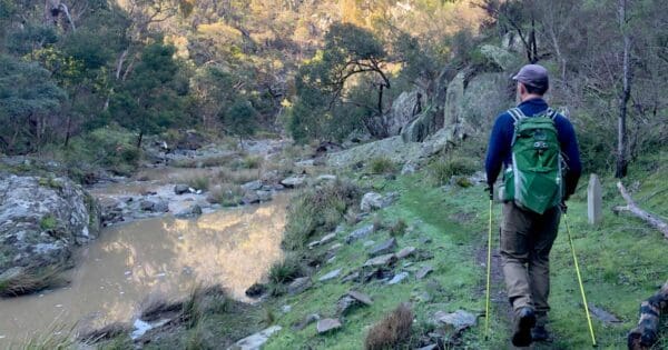
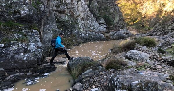
Commence the hike at the Steiglitz Court House and follow Sailors Track to Sutherland Creek, turning north upon reaching the creek. Evidence of early gold mining activities can be observed along the way. Exercise extreme caution, as hidden mine shafts and uncovered holes are often concealed within the long grass near the creek’s edge. Navigate the creek bed by rock hopping where possible.
As you progress upstream, quartz deposits may be visible in the creek bed. Approximately two hours into the hike, look for distinctive rock formations on the creek’s left side, north of Miners Track.
Track grade
Grade 4 (Hard) - Challenging Walks for Experienced Walkers: Grade 4 on the AWTGS signifies challenging walking tracks. Bushwalking experience is recommended for these tracks, which may be long, rough, and very steep. Directional signage may be limited, requiring a good sense of navigation. These walks are suited for experienced walkers who are comfortable with steeper inclines, rougher terrain, and potentially longer distances.
Walk map and GPX file
Max elevation: 267 m
Min elevation: 162 m
Total climbing: 313 m
Total descent: -336 m
Content use
Please don’t copy GPX files or content from this site to AllTrails or other platforms. Each trail has been personally mapped, documented, and refined to support Australia’s bushwalking and hiking community. While some details come from land managers, every listing reflects significant personal effort. This is a free, community-driven initiative—your respect helps keep it that way.
Getting there
Getting to the trailhead: Brisbane Ranges National Park.
To reach the trailhead for the Beards Gully and Deadman’s Loop, follow the directions to Steiglitz Court House. Once in Steiglitz, locate Sailors Track and follow it until you reach Sutherland Creek. The trailhead for the Beards Gully and Deadman’s Loop begins where Sailors Track meets Sutherland Creek.
Need a rental car to get you to the hike? Find one here.
Find a place to stay
Wondering where to stay near this hike? Find accommodation close to the trailhead — hotels, cabins and campgrounds nearby. Click the button to view the interactive map.
Closest towns to this walk: Bacchus Marsh, Ballan, Ballarat, Geelong, Gisborne, Gordon, Lara, Little River, Melton, Meredith, Mernda, Werribee
Let someone know
Heading out? Fill in a trip intentions form so someone knows your plans. If things go wrong, they can raise the alarm fast, giving you peace of mind on the trail.
About the region
Steiglitz Historic Park
Steiglitz Historic Park offers a glimpse into Victoria's gold rush era, situated within the Brisbane Ranges National Park, just over an hour's drive from Melbourne. Once a bustling gold mining town with a population exceeding 1000, Steiglitz now stands as a ghost town, preserving its history from the 1860s to the 1890s. At its peak, the town boasted four hotels, a newspaper, various shops, and even an undertaker, serving a community of over 1500 residents.
Today, the town and its surrounding area are protected within the Steiglitz Historic Park. Visitors can enjoy leisurely walks, picnics, or even try their hand at gold panning. A visit to the Steiglitz Court House is essential, showcasing photographs, maps, and relics from the gold rush era. The court house is open to the public on Sundays and public holidays, with additional visits available by arrangement.
Originally named Steiglitz Forest, the area derived its name from the von Stieglitz family, early pastoralists who settled nearby before returning to Ireland. Gold was discovered in 1854, leading to a rapid growth of the town. By the 1860s, the mining industry was dominated by companies, employing a workforce that included a significant number of Chinese miners.
The Steiglitz Court House, constructed in 1875 as gold production declined, stands as the most prominent remaining building. The town's population dwindled further, and by the 1940s, many buildings were removed. The Steiglitz Historic Park was established in 1976, with the court house restored as an information centre.
Visitors to Steiglitz can explore the ghost town, following interpretive signs to learn about its history. Several walking trails offer opportunities for picnics and to appreciate the surrounding natural environment. It is important to respect private property and dwellings within the area.
Brisbane Ranges National Park
Brisbane Ranges National Park, located west of Geelong and southwest of Bacchus Marsh, approximately an hour's drive from Melbourne, is Victoria's richest wildflower habitat and boasts the highest density of koalas in the state. This 7,700-hectare park is a haven for nature enthusiasts, offering a diverse range of walks, bushwalks, and hikes suitable for all fitness levels, from leisurely strolls to multi-day treks.
The park's unique geology, characterised by low mountain ranges intersected by rocky gullies, has preserved a remarkable array of plant and animal life. With over 619 native plant species, including the rare Brisbane Ranges Grevillea, the park is a botanist's paradise. Wildlife enthusiasts will delight in spotting koalas, kangaroos, wallabies, and a variety of birdlife, including over 170 recorded species.
Beyond hiking, the park offers opportunities for picnicking, scenic drives, and camping. It is also significant as part of the Aboriginal cultural landscape, being the traditional lands of the Wadawurrung People.
Want to find the best trails in Brisbane Ranges National Park for an adventurous hike, casual walk, or a family trip? Trail Hiking Australia has the best trails for walking, hiking, running and more.
Similar walks nearby
Looking for more walks in or near Brisbane Ranges National Park? Try these trails with a similar difficulty grade.
Explore safe
Plan ahead and hike safely! Carry enough water, pack layers for changing conditions, and bring safety gear like a torch, PLB, and reliable communication device. Check official sources for trail updates, closures, and access requirements, and review local weather and bushfire advice. Most importantly, share your plans with someone before you go. Being prepared makes for a safer and more enjoyable hike! Stay Safe, Explore More, and Always #ExploreSafe.
Packing checklists
What you carry in your pack depends on factors like weather, terrain, and your adventure type. Not sure what to bring? My free planning, food, and packing checklists are a great starting point, covering day hikes, overnight trips, and multi-day adventures. Use them to customise your kit and always prioritise safety.
Suggest an edit
Notice something different about this trail? Whether it’s a new feature, a route change, or a closure, share your update so we can keep our info accurate and helpful for fellow hikers.
Click to suggest edits >>
Acknowledgement of Country
Trail Hiking Australia acknowledges the Traditional Owners of the lands on which we hike and pay respects to their Elders, past and present, and we acknowledge the First Nations people of other communities who may be here today.
/Beards-Gully-Deadmans-Loop%20(26).jpg)
/Beards-Gully-Deadmans-Loop%20(12).jpg)
/Beards-Gully-Deadmans-Loop%20(1).jpg)
/Beards-Gully-Deadmans-Loop%20(41).jpg)
/Beards-Gully-Deadmans-Loop%20(5).jpg)
/Beards-Gully-Deadmans-Loop%20(19).jpg)
/Beards-Gully-Deadmans-Loop%20(28).jpg)
/Beards-Gully-Deadmans-Loop%20(40).jpg)
/Beards-Gully-Deadmans-Loop%20(25).jpg)
/Beards-Gully-Deadmans-Loop%20(20).jpg)
/Beards-Gully-Deadmans-Loop%20(3).jpg)
/Beards-Gully-Deadmans-Loop%20(18).jpg)
/Beards-Gully-Deadmans-Loop%20(43).jpg)
/Beards-Gully-Deadmans-Loop%20(16).jpg)
/Beards-Gully-Deadmans-Loop%20(35).jpg)


5 Reviews on “Beards Gully & Deadman's Loop Hike (9.5km)”
Muriel Pepper Steven Parker Mani Andreetta ?
Lynda Maddison I have done this one before. Was fun exploring so happy to do it again.
Lynda Maddison I think I might have done this one too. 🤔
Muriel Pepper Steven Parker I don’t think I’ve done it and it sounds fun so let’s put it in the list 😁
Lynda Maddison Like. Let’s do it.
Lynda Maddison if I remember correctly part of this walk is in a dry riverbed which is very overgrown. Best time to do it would be winter when the danger doodles are asleep.
Fun hike this one. Nice bit of exploration along the creek.
Darren Edwards must be good after all the 🌧