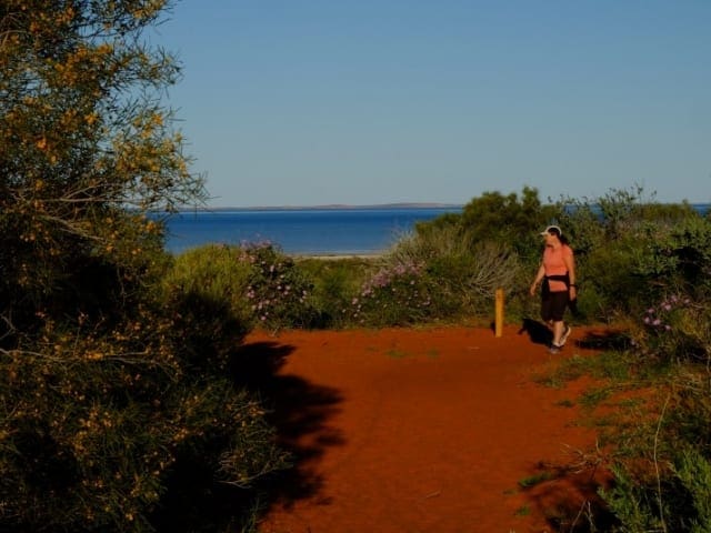
Located between Skipjack Point and Cape Peron in Francois Peron National Park this 3.6km return walk offers excellent views of the area's abundant marine life from the cliff top. Striking red sand cliffs provide great photographic opportunities.
The drive to the northern tip of Francois Peron National Park goes through sections of very soft sand and requires a 4WD. Cape Peron with its vivid red dunes, white beaches combined with blues seas and blue skies make a great end point. To really appreciate the raw natural beauty of this special place, there is a short walk through dunes to a couple of lookouts. In spring, wildflowers paint the dunes in colour and the air is full of Birdsong. If the wind is not whipping up whitecaps, you have a great chance of seeing a passing parade of marine life. The whole terrestrial and maritime combination makes a breathtaking sight, well worth the effort of getting there.
Start Point: Cape Peron, 50km from Denham which is 826km (9 hours) north of Perth
End Point: Cape Peron, 50km from Denham which is 826km (9 hours) north of Perth
Region: Cape Peron, Coral Coast
For more information, a location map and GPS file please visit Trails WA.
Got some great shots from this hike? Upload your photos here to inspire others and show off the beauty of the trail!
Submitting your photos doesn’t mean you lose ownership. You can be credited for your contributions, and you can request removal at any time.
Please don’t copy GPX files or content from this site to AllTrails or other platforms. Each trail has been personally mapped, documented, and refined to support Australia’s bushwalking and hiking community. While some details come from land managers, every listing reflects significant personal effort. This is a free, community-driven initiative—your respect helps keep it that way.
It looks like I don’t have a GPX file for this trail yet. If you have one to share, please email it to me! I’ll verify it against official maps before adding it to help other hikers have a safer, easier experience. Thanks for contributing to a better hiking resource.
Getting there
Getting to the trailhead: Francois Peron National Park.
Closest towns to this walk: Carnarvon, Denham, Gascoyne Junction, Geraldton, Green Head, Monkey Mia, Shark Bay
About the region
Cape Peron has rugged limestone cliffs with sandy beaches and offshore reefs, while its northern shore is more sheltered. It is popular for sightseeing, fishing, walking, diving, swimming and picnicking. Enjoy the coastal beauty of Cape Peron on a walk along its shores or take the plunge to explore some of the underwater features of the Shoalwater Islands Marine Park. The waters surrounding Cape Peron are dotted with numerous reefs, caves and swimthroughs.
Similar walks nearby
Looking for more walks in or near Francois Peron National Park? Try these trails with a similar difficulty grade.
Favourite

Favourite

Regional Western Australia
Favourite

Favourite

Track grade
Grade 2 (Easy) - A Gentle Introduction to Inclines: Grade 2 on the
AWTGS represents easy walking tracks that offer a slightly more challenging experience compared to Grade 1. Similar to Grade 1, no prior bushwalking experience is required. The track surface is typically hardened or compacted and may have gentle hill sections or occasional steps. The total distance of a Grade 2 walk is typically no greater than 10 kilometers. These walks are still suitable for families with a bit more experience or those seeking a gentle introduction to some inclines.
Explore safe
Plan ahead and hike safely! Carry enough water, pack layers for changing conditions, and bring safety gear like a torch, PLB, and reliable communication device. Check official sources for trail updates, closures, and access requirements, and review local weather and bushfire advice. Most importantly, share your plans with someone before you go. Being prepared makes for a safer and more enjoyable hike! Stay Safe, Explore More, and Always #ExploreSafe.
Packing checklists
What you carry in your pack depends on factors like weather, terrain, and your adventure type. Not sure what to bring? My free planning, food, and packing checklists are a great starting point, covering day hikes, overnight trips, and multi-day adventures. Use them to customise your kit and always prioritise safety.
Let someone know
Before heading out, take a moment to fill out your trip intentions form. It’s a quick way to share your hike details with family or friends. If something goes wrong, they can notify emergency services, ensuring a faster response and peace of mind. Stay safe and enjoy your adventure
Suggest an edit
Spotted a change on this trail? Maybe there are new features, the route has shifted, or the trail is permanently closed. Whatever the update, I’d love your input. Your feedback helps fellow hikers stay informed and ensures that our trail info stays fresh and reliable.


