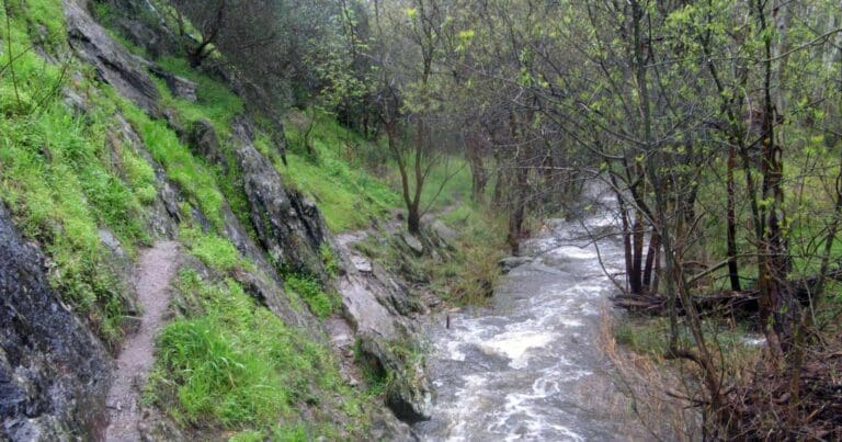
Challenge yourself with the Upper Sturt Gorge River Circuit, a 7.6-kilometre loop trail located within Sturt Gorge Recreation Park, South Australia. This moderately challenging (grade 4) hike takes roughly 3.5 hours to complete and is recommended for experienced walkers due to its adventurous nature.
The circuit follows the upper section of the River Trail, offering an exciting exploration that involves multiple river crossings and sections of rock scrambling. Be aware that following heavy rainfall, the river level may rise, potentially submerging the stepping stones used for the eight river crossings.
For those seeking a starting point, Gate 12 on Broadmeadow Drive (opposite house number 106) provides convenient access to the loop trail.
For more information on this hiking trail, please visit Walking SA
Got some great shots from this hike? Upload your photos here to inspire others and show off the beauty of the trail!
Submitting your photos doesn’t mean you lose ownership. You can be credited for your contributions, and you can request removal at any time.
Please don’t copy GPX files or content from this site to AllTrails or other platforms. Each trail has been personally mapped, documented, and refined to support Australia’s bushwalking and hiking community. While some details come from land managers, every listing reflects significant personal effort. This is a free, community-driven initiative—your respect helps keep it that way.
Total distance: 7635 m
Max elevation: 192 m
Min elevation: 94 m
Total climbing: 276 m
Total descent: -276 m
Getting there
Getting to the trailhead: Sturt Gorge Recreation Park.
Easily accessible by car, Sturt Gorge Recreation Park lies approximately 13 kilometres south of Adelaide. While vehicle access is restricted within the park itself, numerous pedestrian entry points provide convenient access. These entry points are scattered around the park’s perimeter, offering various starting points for your exploration. For instance, you can enter from Broadmeadow Drive, Black Road, or Bonneyview Road in Flagstaff Hill; The Boulevard in Bellevue Heights; or Craigburn Road in Craigburn Farm. Plan your route based on the area you’d like to explore first, and lace up your walking shoes to discover the wonders of Sturt Gorge Recreation Park.
Closest towns to this walk: Aberfoyle Park, Bedford Park, Belair, Blackwood, Coromandel Valley, Eden Hills, Flagstaff Hill, Happy Valley, Marion, Sturt
About the region
Explore the ancient wonders and natural beauty of Sturt Gorge Recreation Park. Internationally recognized for its geological significance, the park boasts the nationally threatened greybox grassy woodland vegetation, once widespread across southern Australia. A geological marvel, the park is also home to sturt tillite, a rock formation believed to be 800 million years old, formed from glacial material left behind by a prehistoric ocean.
The recent addition of Craigburn Farm has significantly expanded the park's area. Transformed into a major revegetation site, it now offers a haven for mountain bikers and hikers. Explore a network of well-maintained trails, encountering the park's oldest rock formations amidst flourishing grasslands and open woodlands.
Cycling enthusiasts can choose between designated mountain bike trails or explore the park's public access roads. Hikers can traverse the park's scenic slopes and shrublands, keeping an eye out for the diverse native fauna that frequent the waterholes lining the Sturt River.
For an optimal experience, consider visiting during autumn or spring. While summer offers warm weather, it can also be hot and dry. However, if you visit after a period of heavy rain, you might be rewarded with a vibrant display of wildflowers and the delightful sounds of frogs in the flowing creeks.
Similar walks nearby
Looking for more walks in or near Sturt Gorge Recreation Park? Try these trails with a similar difficulty grade.
Favourite

Sturt Gorge Recreation Park
Favourite

Sturt Gorge Recreation Park
Favourite

Shepherds Hill Recreation Park
Favourite

Track grade
Grade 4 (Hard) -
Challenging Walks for Experienced Walkers: Grade 4 on the
AWTGS signifies challenging walking tracks. Bushwalking experience is recommended for these tracks, which may be long, rough, and very steep. Directional signage may be limited, requiring a good sense of navigation. These walks are suited for experienced walkers who are comfortable with steeper inclines, rougher terrain, and potentially longer distances.
Explore safe
Plan ahead and hike safely! Carry enough water, pack layers for changing conditions, and bring safety gear like a torch, PLB, and reliable communication device. Check official sources for trail updates, closures, and access requirements, and review local weather and bushfire advice. Most importantly, share your plans with someone before you go. Being prepared makes for a safer and more enjoyable hike! Stay Safe, Explore More, and Always #ExploreSafe.
Packing checklists
What you carry in your pack depends on factors like weather, terrain, and your adventure type. Not sure what to bring? My free planning, food, and packing checklists are a great starting point, covering day hikes, overnight trips, and multi-day adventures. Use them to customise your kit and always prioritise safety.
Let someone know
Before heading out, take a moment to fill out your trip intentions form. It’s a quick way to share your hike details with family or friends. If something goes wrong, they can notify emergency services, ensuring a faster response and peace of mind. Stay safe and enjoy your adventure
Suggest an edit
Spotted a change on this trail? Maybe there are new features, the route has shifted, or the trail is permanently closed. Whatever the update, I’d love your input. Your feedback helps fellow hikers stay informed and ensures that our trail info stays fresh and reliable.


