Hike at a Glance
Max elevation: 723m
Min elevation: 350m
Total Ascent: 1123m
Important info
Update 31/08/2022: West track off the Tarra Valley Rainforest loop walk is closed due to storm damage. Walkers can still access the Cyathea Falls from the east track. Please return the same way and do not attempted to walk the loop.
Hike overview
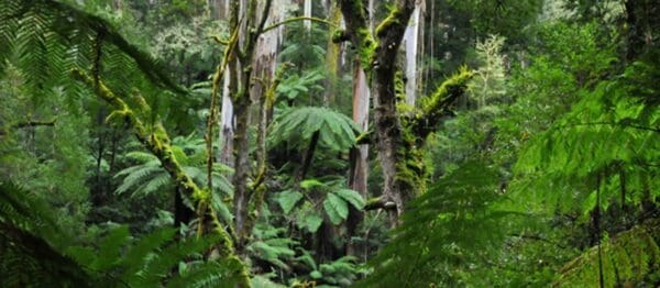
The Tarra Valley loop is is a wondrous hike through the magnificent Tarra Valley, home to some of the best primeval rainforest in Victoria.
This trail features an array of waterfalls, including Cyathea Falls and Tarra Falls, and many endangered Slender Tree-ferns (Cyathea cunninghamii), as well as ancient specimens of Myrtle Beech (Nothofagus cunninghamii).
There's a great picnic area in the Tarra Valley - perfect for a quiet lunch with your friends and family.
During the walk you'll have great views of the Ninety Mile Beach and surrounds, as well as the chance to observe the recovering native forest, decimated by the 2009 Black Saturday bushfires.
This section of the GST connects with the Tarra Valley settlement offering accommodation such as caravan parks or three-star bed and breakfast.
Track grade
Grade 3 (Moderate) - Walks for Most Fitness Levels: Grade 3 on the AWTGS represents moderate walking tracks. These are ideal for walkers with some fitness who are comfortable with some hills and uneven terrain. While suitable for most ages, some bushwalking experience is recommended to ensure a safe and enjoyable experience. Tracks may have short, steep hill sections, a rough surface, and many steps. The total distance of a Grade 3 walk can be up to 20 kilometers.
Walk map and GPX file
Max elevation: 723 m
Min elevation: 350 m
Total climbing: 1123 m
Total descent: -1124 m
Content use
Please don’t copy GPX files or content from this site to AllTrails or other platforms. Each trail has been personally mapped, documented, and refined to support Australia’s bushwalking and hiking community. While some details come from land managers, every listing reflects significant personal effort. This is a free, community-driven initiative—your respect helps keep it that way.
Gallery
Got any photos from this hike? Your photos can help others plan. Share shots from along the trail so fellow hikers know what to expect.
Click to add your photos >>
Getting there
Getting to the trailhead: Tarra Bulga National Park.
Tarra Bulga National Park is situated approximately 200 kilometres east of Melbourne. The park is reached from the Princes Highway at Traralgon by following Traralgon Creek Road to Balook. Alternatively the park can be reached from Yarram via the Tarra Valley Road or Bulga Park Road. Roads throughout the area are narrow and winding but offer marvelous scenery with panoramic views from several points, including Mount Tassie.
Need a rental car to get you to the hike? Find one here.
Find a place to stay
Wondering where to stay near this hike? Find accommodation close to the trailhead — hotels, cabins and campgrounds nearby. Click the button to view the interactive map.
Closest towns to this walk: Boolarra, Churchill, Gormandale, Mirboo North, Moe, Tanjil South, Thorpdale, Toora, Trafalgar, Traralgon, Traralgon South, Welshpool, Yarram, Yinnar
Let someone know
Heading out? Fill in a trip intentions form so someone knows your plans. If things go wrong, they can raise the alarm fast, giving you peace of mind on the trail.
About the region
With its lush gullies, giant mountain ash trees and tree ferns, Tarra Bulga National Park is one of only four major areas of cool temperate rainforest in the state. The rainforest is a haven for plants and wildlife. Discover a wide variety of birds including the pilotbird, yellow tailed black cockatoo, eastern whipbird, and currawongs. Visit in the evening when the forest comes to life as possums, owls and bats emerge to feed. If you're lucky, you may see a lyrebird scratching the forest floor looking for food or catch a glimpse of some of the other inhabitants like wombats, swamp wallabies, gliders and platypuses.
Similar walks nearby
Looking for more walks in or near Tarra Bulga National Park? Try these trails with a similar difficulty grade.
Explore safe
Plan ahead and hike safely! Carry enough water, pack layers for changing conditions, and bring safety gear like a torch, PLB, and reliable communication device. Check official sources for trail updates, closures, and access requirements, and review local weather and bushfire advice. Most importantly, share your plans with someone before you go. Being prepared makes for a safer and more enjoyable hike! Stay Safe, Explore More, and Always #ExploreSafe.
Packing checklists
What you carry in your pack depends on factors like weather, terrain, and your adventure type. Not sure what to bring? My free planning, food, and packing checklists are a great starting point, covering day hikes, overnight trips, and multi-day adventures. Use them to customise your kit and always prioritise safety.
Suggest an edit
Notice something different about this trail? Whether it’s a new feature, a route change, or a closure, share your update so we can keep our info accurate and helpful for fellow hikers.
Click to suggest edits >>
Acknowledgement of Country
Trail Hiking Australia acknowledges the Traditional Owners of the lands on which we hike and pay respects to their Elders, past and present, and we acknowledge the First Nations people of other communities who may be here today.


3 Reviews on “Tarra Valley Loop Hike (21.1km)”
Completed 4.10.22 in 9hrs (not 6). Several passable fallen trees and some mud lower than ankle deep. Recommend spraying lower legs with DEET or similar for leeches.
Currently (apparently from 11th March, 2022- and we just tried to walk it on the 23rd April 2022) the Tarra Valley Link Track and the Diaper Track section of the walk is closed due to fallen trees. If walking anticlockwise it is possible to walk from the information centre to the Tarra Valley Car Park however it is a long slog back along the road to the visitor centre